Blog Article
July 4th Weather: Heat Wave and Midwest Storms Ahead
A dangerous heat wave expands east for July 4th weekend while severe storms keep hitting the Upper Midwest. What it means for cookouts, races, and festivals.
A Hot Dog, a Heat Wave, and a Long Weekend: What July 4th Weather Is Setting Up
Alright folks, let's talk about the weekend everybody's already planning around. Nathan's Hot Dog Eating Contest in Brooklyn. The Peachtree Road Race in Atlanta. Summerfest down in Milwaukee. Parades, cookouts, fireworks, the whole American summer playbook. And the news headlines are already telling you the punchline: it's going to be a hot one.
Here's the thing. Two weather stories are running at the same time right now, and both of them land right on top of where folks want to be this weekend. One is heat. The other is a storm machine over the Upper Midwest that just will not quit. Let me walk you through both, because they're going to shape a lot of conversations between now and the Fourth.
The heat is the real headline
The trending searches don't lie. "Record-Breaking Heat Wave Expected to Hit New York City Ahead of July 4 Weekend." An Extreme Heat Warning getting talked about for the entire state of Connecticut Wednesday through Saturday. This is the big one.
The forecast guidance for Wednesday shows heat indices running 105 to 115 degrees across the Midwest and Mississippi Valley, and that heat is expanding into the Mid-Atlantic and Ohio Valley. Heat index is the number that matters here. It's what the air actually feels like once you fold in the humidity, because when it's muggy, your sweat can't evaporate and cool you down the way it's supposed to.
Now think about the events. Joey Chestnut and the rest of the field are going to be standing on a stage in Brooklyn on the Fourth, eating in the sun. The Peachtree Road Race sends sixty-thousand-plus runners through Atlanta that same morning, where the late-June normal high is already 87 degrees. Add a heat dome on top of that, and you've got conditions that organizers take seriously. They've cut start times and added water before. Watch for that.
If you're heading to any outdoor event this weekend, the rules are boring but they work. Drink water before you're thirsty. Find shade on a schedule, not just when you feel cooked. Check on the older folks and the little ones, because they heat up faster and tell you about it slower.
Meanwhile, the Midwest storm machine keeps cranking
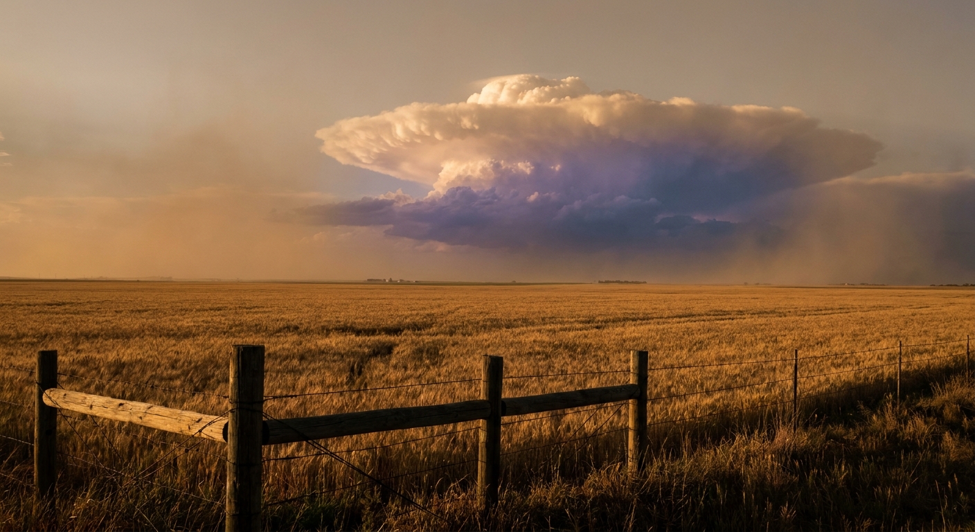
Remember that system we talked about this morning? The one that put a measured 131 mph wind gust in Hyde County, South Dakota? That same broad pattern is still in business, and it's marching the threat east.
The Storm Prediction Center has an Enhanced Risk (that's level 3 of 5) for Wednesday across southern Minnesota into northern and central Wisconsin and northern Lower Michigan. We're talking Green Bay, Traverse City, Escanaba. The SPC discussion spells out damaging wind gusts, some up to 80 mph, with large hail and a couple tornadoes possible. The Weather Prediction Center also has a Slight Risk for excessive rainfall over the Upper Midwest, with Wisconsin in the crosshairs for flash flooding.
Here's why this keeps happening. There's a strong ridge of high pressure parked over the country building that heat dome we just talked about. Storms ride the northern edge of that ridge like cars on a highway, one round after another, in what meteorologists call northwest flow. Each round leaves a boundary behind, and the next round fires right along it. That's the engine behind the back-to-back severe days the Upper Midwest has been living through.
And the timing matters culturally. Summerfest Weekend 3 kicks off in Milwaukee on Thursday, July 2. Wisconsin is exactly where the rain and storm threat sits Wednesday into Thursday. If you're headed to the festival grounds, keep your weather app handy and know where you'd go if they pause the music.
What about the actual Fourth?
Good news and a caveat. The extended guidance keeps a stagnant pattern through the holiday, which means the West stays pleasant and the central and eastern parts of the country stay warm, humid, and prone to those pop-up afternoon and evening storms. Nothing in the data points to a single organized severe outbreak nailed down for July 4 yet, but scattered storms are a real possibility for the Midwest, Northeast, and Southeast.
For most folks that means the fireworks question isn't if a storm is coming, it's whether an afternoon cell drifts over your town right at showtime. Have a backup plan and check the local forecast the morning of.
The takeaway
The story of this long weekend is heat first, storms second. The heat is the broad, dangerous, everybody-feels-it threat from the Plains to the East Coast. The storms are the sharper, more localized risk riding the top of that same ridge over the Upper Midwest. If your weekend involves standing outside, and for most of America it does, the smartest thing you can pack is water and a plan. Eat your hot dogs, run your race, light your sparklers. Just respect the heat while you do it.