Blog Article
U.S. Weather Forecast: Extreme Temp Divide, Snow & Ice Threats
Tracking a massive U.S. temperature divide, quick-hitting Midwest snow today, and a new wintry mix and icing threat for the Ohio Valley next week.
A Massive Temperature Divide, Fast-Moving Snow, and Our Next Icing Threat
Alright folks, let's talk about this wild weather pattern. As we talked about last week, that Nor'easter was an absolute monster. Parts of Rhode Island saw over 37 inches of snow, and we had hurricane-force gusts knocking out power all over Massachusetts. I hope everyone up there is finally getting dug out and staying warm.
But here is the thing. The atmosphere just does not want to calm down. We are swinging from one extreme to another, and this weekend is bringing a massive temperature divide across the country. Plus, we are already tracking our next big wintry mess for next week.
Let's get right into it.
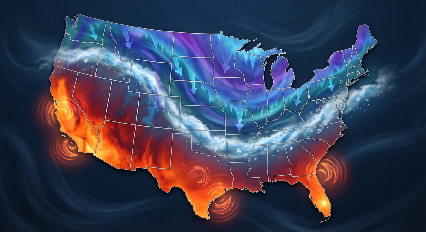
The Great American Temperature Divide
Get this. We are looking at a national temperature spread of nearly 170 degrees from top to bottom. Up in Arctic Alaska, they are dealing with life-threatening wind chills of 70 degrees below zero. Meanwhile, down in the Southwest and Southern Plains, folks are cranking the AC.
A warm ridge of high pressure is locked in over the Southwest. If you are heading out to the Diamondbacks Spring Training game in Peoria today, you need to hydrate. Temperatures are soaring into the middle and upper 90s. Even the California valleys are pushing into the upper 80s to near 90 degrees. It feels like the middle of summer out there.
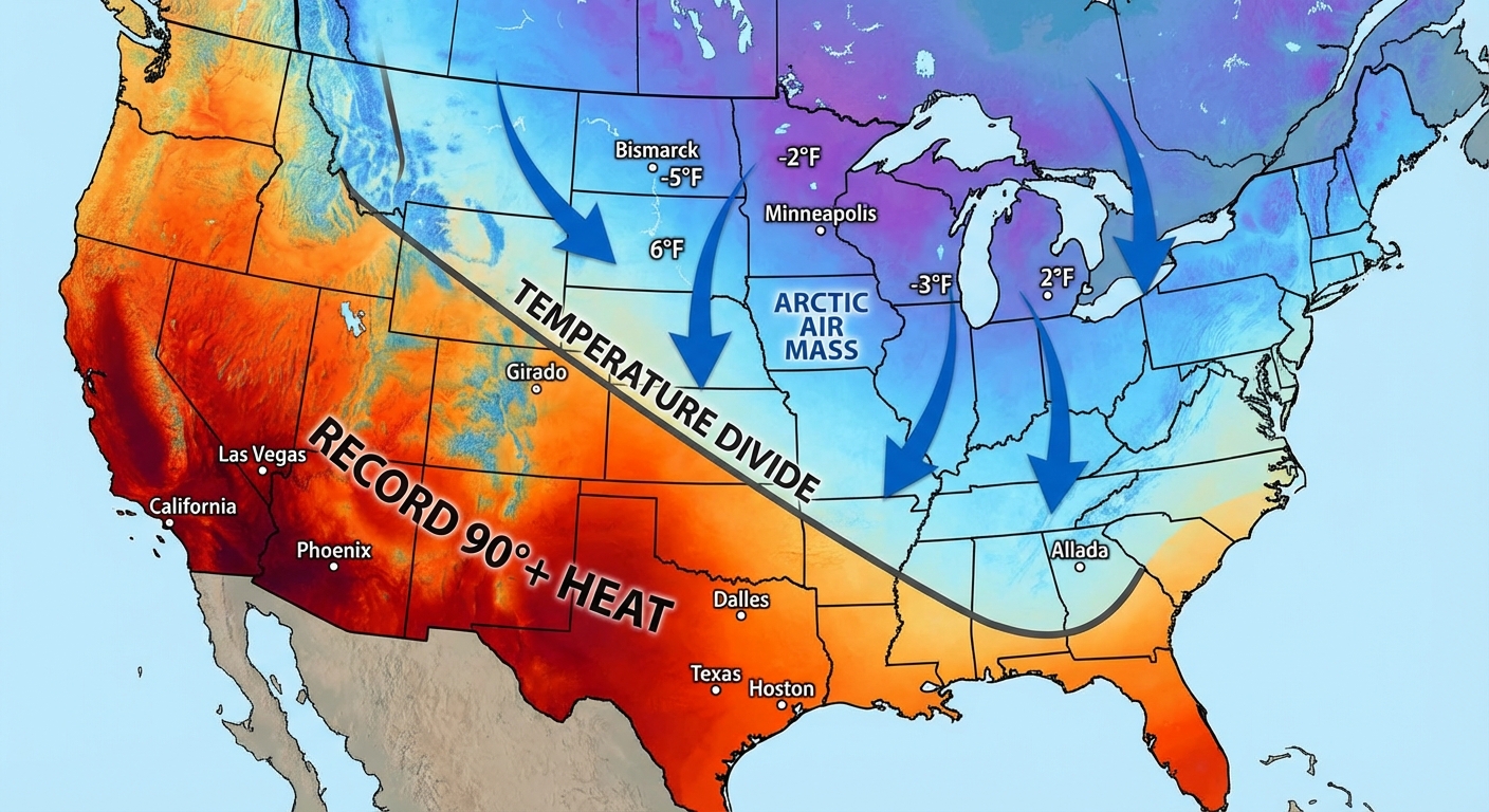
But on the flip side, an outbreak of Arctic air is surging across the northern tier states. We have a strong cold front pushing south, and it is bringing temperatures 15 to 20 degrees below normal for a huge chunk of the country.
Quick-Hitting Snow and Florida Storms Today
Because of that Arctic front, we have a narrow but intense band of snow tracking from the Dakotas right through the Great Lakes today.
Now, this is a fast-moving system. It is not going to sit and dump feet of snow on you. But the air is so cold that this is going to be a very fluffy, dry snow. That means it will accumulate quickly. We are expecting a solid 2 to 5 inches across southern Minnesota and Wisconsin, and we could see snowfall rates of 1 inch per hour late this morning.
If you are heading out to the Michigan Brewers Guild Winter Beer Festival in Comstock Park today, or the Chicago Beer Fest, you better bundle up. It is going to be a true jacket and beanie kind of day.
Down south, we have a completely different story. A Marginal Risk for severe storms is clipped right over the Florida Peninsula today. If you are going to the FuelFest in West Palm Beach or just hanging out around Miami and Fort Lauderdale, keep an eye on the radar. We could see some isolated strong storms with gusty winds and maybe some hail this afternoon and evening.
Next Week's Messy Setup
Alright y'all, let's look ahead to next week. We have a split upper flow pattern setting up, and it is going to get active.
By Tuesday, a system is going to eject out of the Southwest and run right into that cold Arctic air parked over the northern half of the country. When you mix Gulf moisture with freezing surface temperatures, you get a mess.
Right now, the Weather Prediction Center is highlighting a 30 to 50 percent probability of measurable ice from eastern Nebraska and Kansas, right through the Mid-Mississippi and Ohio Valleys. We are talking about a wintry mix of snow, sleet, and freezing rain. If you live in this corridor, you need to start thinking about your Tuesday and Wednesday morning commutes. Even a tiny glaze of ice can turn the roads into a skating rink.
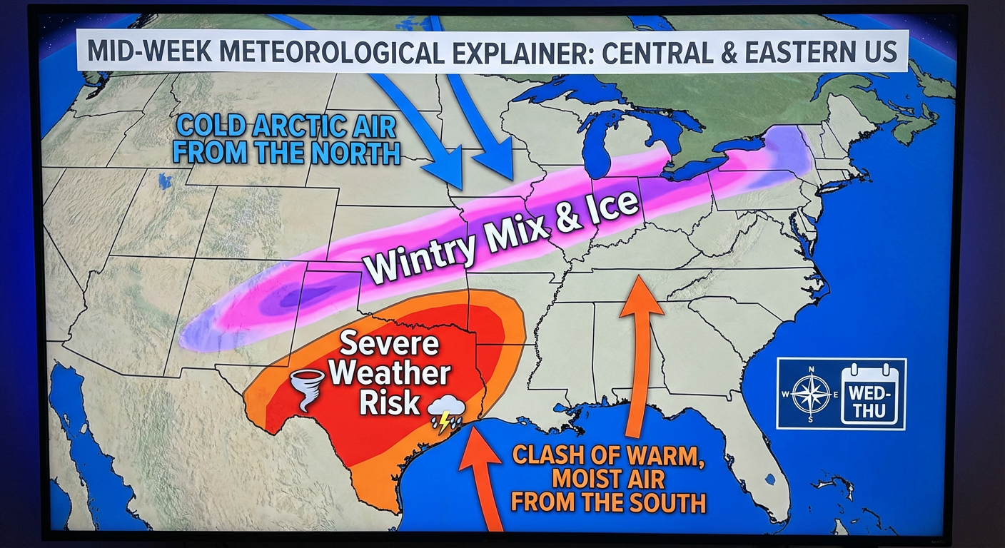
At the exact same time, the southern side of this system is going to tap into some serious instability. By Wednesday, we have a 15 percent risk area for severe thunderstorms covering the Dallas and Fort Worth metroplex. We could be looking at supercells capable of producing damaging winds and large hail.
Key Things We Are Watching
- The Ohio Valley Ice Threat: Tuesday into Wednesday is looking slick. We will be dialing in the exact freezing line over the next couple of days.
- Texas Severe Storms: Wednesday afternoon and evening look bumpy for the Southern Plains.
- Critical Fire Weather: We still have elevated fire risks in the central High Plains today. Dry winds dropping out of the mountains are keeping humidity super low.
- Space Weather: Just a quick heads up for my aurora chasers and tech geeks. We have a G1 Minor Geomagnetic Storm forecast due to a solar eruption from a few days ago.
Bottom Line
The transition from February to March is living up to its reputation. We are seeing winter's last gasp fighting against early spring heat.
If you are in the Upper Midwest today, take it slow on the roads. That fluffy snow will make things slick in a hurry. If you are in the Southwest, enjoy the early pool weather but stay cool. And if you live anywhere from the Central Plains through the Ohio Valley, use this weekend to prepare for a potentially icy commute by Tuesday.
Stay weather aware, check your local forecasts, and I will be back with another update as we get closer to that mid-week storm. Have a great weekend y'all.