Blog Article
A Memorable Storm Is Coming
A major winter storm will impact the Southern and Eastern U.S. from Friday through the weekend. Heavy snow is likely from Oklahoma to the Mid-Atlantic, with dangerous ice from Texas to the Carolinas. Prepare now for power outages and hazardous travel.
Yesterday I said this could be the big one. Today, my confidence is even higher.
Model guidance continues to come into better agreement on what is shaping up to be a significant, potentially historic winter storm affecting a huge swath of the Southern and Eastern United States from Friday through the weekend. The National Weather Service has now issued formal messaging highlighting the threat. This is shaping up to be the kind of event that could leave people without power for days and strand travelers on highways.
Here's everything we know as of this morning, and what still remains uncertain.
The Scale of This Event
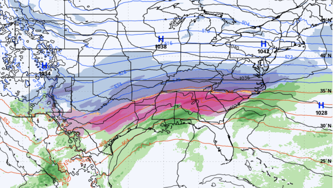
This storm is big. Continental-scale big.
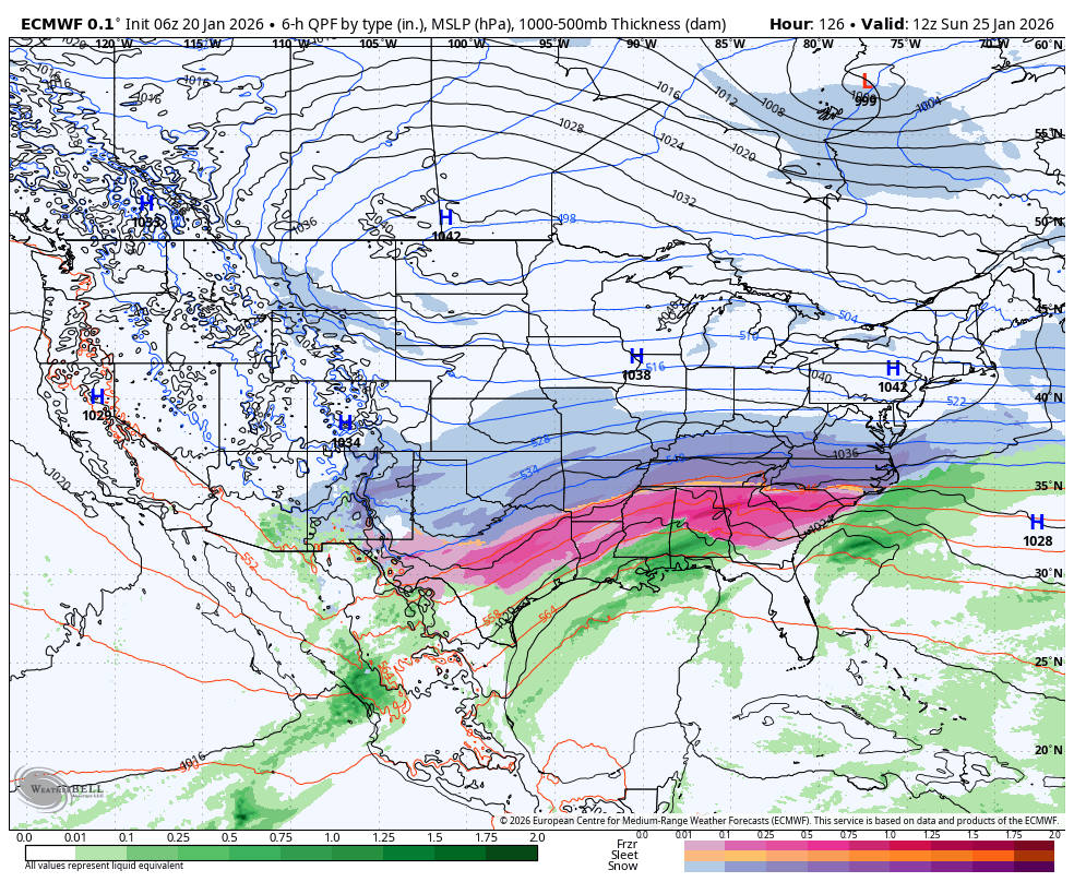
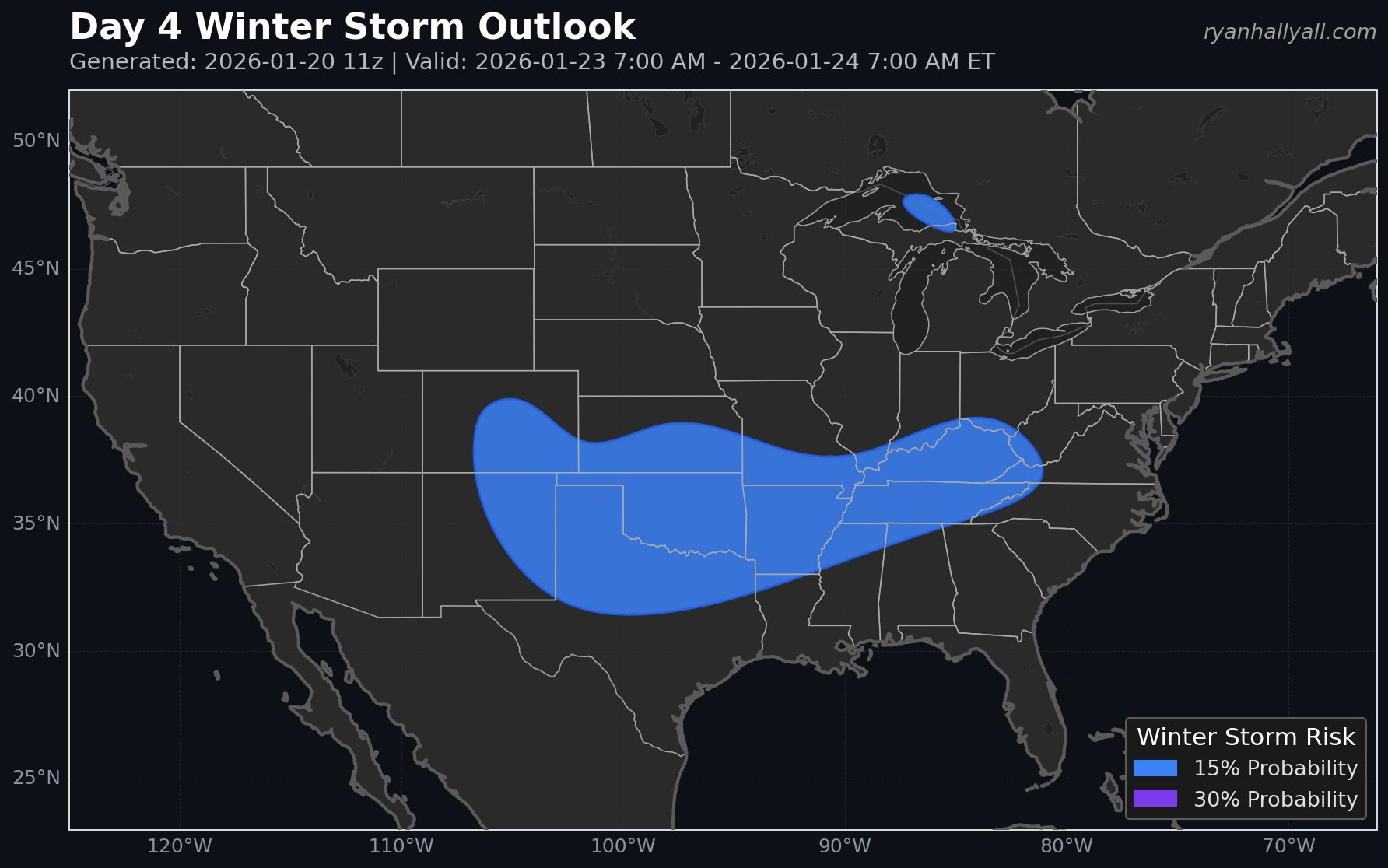
By Sunday morning, the combined snow and ice shield is forecast to stretch roughly 2,000 miles from the Southwest to the East Coast. We're looking at somewhere around 160 million people experiencing wintry precipitation simultaneously at that point. That's not a typo.
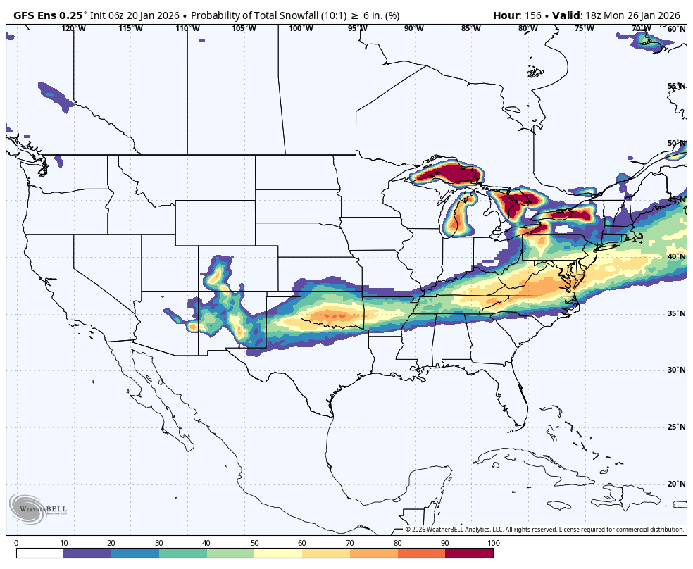
Probabilities for receiving at least three inches of snow through January 26 now exceed 80 to 90 percent across a broad corridor stretching from Oklahoma and Arkansas through Tennessee, Kentucky, and into the Mid-Atlantic states including Virginia and the Carolinas. The snow sweet spot spans from the Southern Plains through the Mid-South, Southeast, and Mid-Atlantic. There will be a sharp snow-ice cutoff in the Deep South.
The Northeast will be near the northern edge of this system. Probabilities there are considerably lower, though not zero.
Snow Expectations
Heavy snowfall is expected across portions of Oklahoma, northern Texas, and Arkansas beginning Friday, spreading eastward into the Tennessee Valley by Saturday. Given the arctic nature of the cold sector, temperatures will be well down into the teens and 20s across much of the snow zone. This supports snow-to-liquid ratios well above climatology, meaning we'll see efficient accumulations even with modest liquid equivalent.
By the weekend, the heaviest snow corridor looks to extend from the Tennessee Valley into the Virginias and Maryland. Snow-covered roads and reduced visibilities will be the primary hazards across this zone. Very heavy totals are possible in the bullseye areas, though the exact placement of that bullseye still has some wiggle room.
The Ice Threat
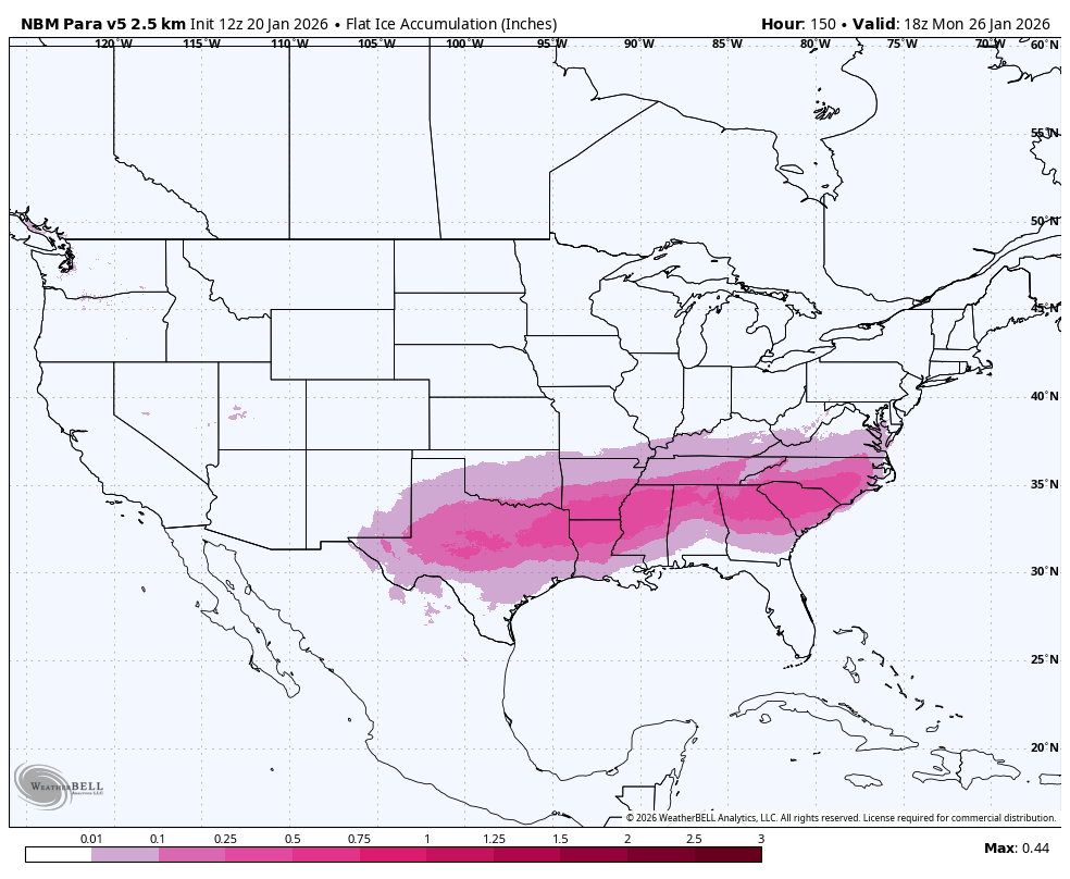
South of the snow line, a dangerous icing setup is evident where the warm nose aloft overlaps sub-freezing surface temperatures. Freezing rain is likely from central Texas into the Lower Mississippi Valley, with significant ice accretions possible before a transition to rain or ending as snow depending on the track of the surface low.
One important note. Over the next few days you're going to see a lot of maps showing freezing rain QPF amounts. Some of these will look absolutely terrifying, with values of one to two inches or more across large areas. Be careful with those maps.
Freezing rain QPF shows how much precipitation falls in the form of freezing rain. That is not the same thing as how much ice actually accumulates on surfaces. Actual ice accretion depends on additional factors including surface temperatures, wind, and how quickly the precipitation falls. Those raw QPF maps will be overdone. A major ice storm is increasingly likely, but don't take those numbers at face value.
That said, even with more realistic ice accretion estimates, the icing threat is significant. The zone from central Texas through the Mid-South and into the Carolinas faces hazardous conditions. Power outages and tree damage are real concerns, and some areas could see multi-day outages.
Why Models Disagree on the Northern Extent
One of the main questions right now is how far north the heavy snow will extend. If you've been watching the models, you've probably noticed the ECMWF is showing a significantly farther north snow track than most other guidance.
Here's why. The ECMWF has the Southwest U.S. trough ejecting northeastward significantly slower than other models. This prolongs the duration of the event and allows snow to expand farther north over time. The ECMWF also shows more amplitude in the northern stream trough, which leads to higher heights downstream and pushes the snow shield much farther north.
At this time, the deterministic ECMWF is an outlier compared to its own ensemble members on these features. But here's the thing. Being an outlier at this lead time doesn't mean it's wrong. Historical errors with north stream features at this range mean we can't rule it out. The ECMWF isn't being unrealistic. It's showing one plausible scenario that other models aren't picking up on yet.
For practical purposes, this means there's still uncertainty about exactly how far north heavy snow will extend. The consensus favors impacts focused on the Southern Plains through the Mid-Atlantic. But a northward expansion into portions of the Ohio Valley or even farther north remains possible if the ECMWF solution verifies.
What I'm Still Watching
Despite the increasing confidence in the overall storm, several important details remain unresolved.
North versus south snow axis. The strong antecedent tropopause polar vortex and strong high pressure support a southern-focused event. But the slower ejection and stronger northern stream interaction in some guidance could shift the heaviest snow corridor north.
Exact precipitation type boundaries. Small fluctuations in the thermal profile will dictate where the transition zone between snow, sleet, and freezing rain sets up. This could shift by 50 to 100 miles in some areas. If you're near the expected boundary, stay flexible.
Ice accretion amounts. While a significant icing event is likely from central Texas through the Carolinas, exact amounts will depend on surface temperatures, precipitation rates, and how long the freezing rain window lasts.
Northeast and New England involvement. There's ensemble spread regarding whether a secondary coastal low could wrap winter impacts back into the Northeast early next week. This remains a lower-confidence scenario, but it's worth watching.
Timeline
Friday, January 23: Storm begins impacting the Southern Plains. Snow develops across portions of the Texas Panhandle, Oklahoma, and into Arkansas. Freezing rain and sleet begin across central Texas and the Lower Mississippi Valley.
Saturday, January 24: Precipitation shield expands eastward into the Tennessee Valley and Southeast. Heavy snow continues across Oklahoma and Arkansas, spreading into Tennessee, Kentucky, and the Virginias. Dangerous ice accumulation continues across the Mid-South.
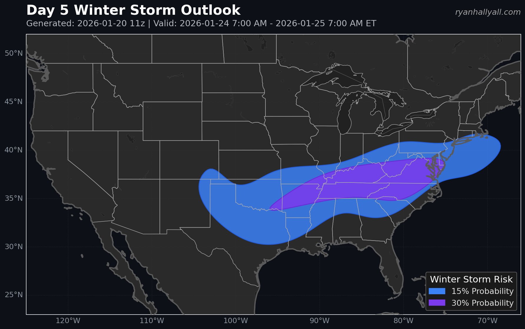
Sunday, January 25: System reaches the Mid-Atlantic and begins exiting the coast. Heavy snow possible from the Virginias into Maryland. Icing threat continues across portions of the Carolinas. This is when the 2,000-mile precipitation shield hits peak coverage.
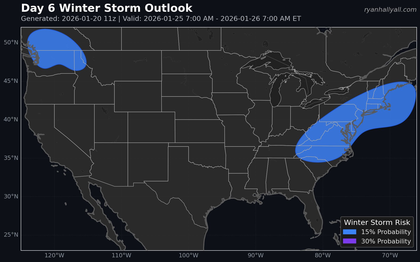
Monday, January 26 and beyond: Primary precipitation shield exits the coast. Uncertainty increases regarding potential secondary development off the coast. Arctic air remains locked in place, keeping snow on the ground across much of the affected region.
The Cold Behind the Storm
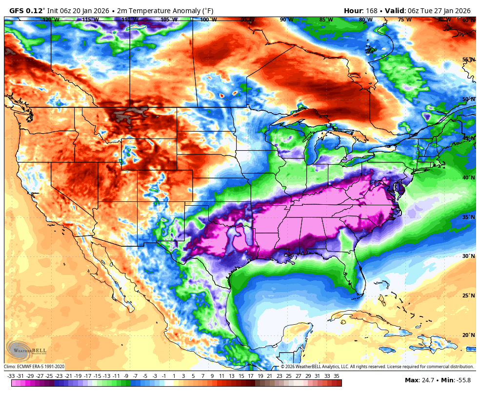
This storm isn't occurring in isolation. An expansive arctic high pressure system will dominate north of the storm track throughout the period. The Northern Plains and Upper Midwest will see dangerous cold with potentially extreme wind chills Friday through Saturday.
This cold air will bleed southward and eastward, keeping temperatures 20 to 30 degrees below average across the central and eastern United States through early next week. That means whatever falls is going to stay on the ground for days. The combination of accumulating snow, ice, and sustained below-freezing temperatures creates a prolonged hazard period well after the precipitation ends.
Bottom Line
This is now a high-confidence event for significant winter impacts across a large portion of the Southern and Eastern United States.
Plan for going days without power this weekend if you're in the icing zone. Expect school cancellations next week across a huge area. Do not plan a road trip this weekend. This could absolutely be a situation where people get stuck on the highway, and I don't say that lightly.
If you live anywhere from the Southern Plains through the Tennessee Valley, Mid-South, Southeast, or Mid-Atlantic, this is a storm to take seriously. Finalize your preparations today and tomorrow. Check on elderly neighbors. Charge your devices. Stock up on essentials. Have a plan for staying warm if the power goes out.
I'll continue to update as the models resolve the remaining uncertainties. But the overall message hasn't changed from yesterday. If anything, it's only gotten stronger.
This is the big one. Be ready.