Blog Article
Southern Plains Flood Threat & Shifting Severe Weather Risk
A stalled boundary brings a flash flood threat to Texas and Oklahoma today, while eastern Colorado faces large hail. A nocturnal wind threat develops Friday.

A Messy Setup for the Southern Plains and a Shift in the Severe Threat
Yesterday was a wild one. We had a consolidated squall line moving through the I-95 corridor producing 60 mph gusts, while at the exact same time, Wyoming was measuring 22 inches of late-season snow. The atmosphere was putting in overtime.
Today, the focus shifts right back to the Southern Plains. If you look at the trending searches online this morning, you will see folks in Houston asking about the rain forecast for the upcoming Memorial Day weekend. They have a very good reason to be asking.
We have a stalled boundary and a whole lot of Gulf moisture surging north.
The Flood Threat Down South
The Weather Prediction Center has a Level 2 out of 4 Slight Risk for excessive rainfall posted today. This covers the upper Texas coast, right through the Houston metro, and stretches up into eastern Oklahoma and southwest Louisiana.
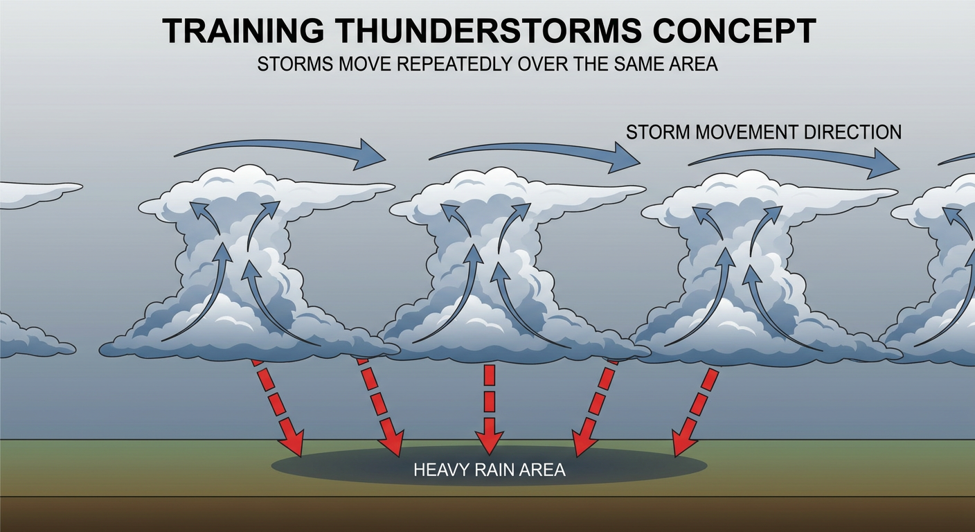
The ground in eastern Oklahoma is already saturated from heavy rain earlier this week. Now we are looking at a setup that favors training thunderstorms. That is a meteorological term for when storms line up like train cars on a track and dump rain over the exact same spot for hours.
If you are driving I-45 or I-10 down south today, leave early and expect delays. Never drive through water covering the road. It only takes a few inches to float a vehicle.
Colorado Hail Today, Texas Wind Tomorrow
Out west, the Storm Prediction Center is watching eastern Colorado today. They have a Level 2 out of 5 Slight Risk for severe storms covering places like Sterling and Lamar.
An upper-level trough is moving into the Rockies right now. By mid-afternoon, we expect storms to fire off the higher terrain. The normal high for Denver in late May is 71 degrees, and temperatures will be sitting right around there today. That provides just enough surface heat to get these updrafts going. The main threats here are large hail around quarter-size and isolated 60 mph wind gusts. A brief spin-up tornado is possible, but the main concern is ice falling from the sky.
Tomorrow is when things get a bit more complicated.
A dryline is going to push into the Texas Panhandle on Friday. A Slight Risk is up for places like Amarillo and over into western Oklahoma near Altus. Storms will likely initiate in the late afternoon as discrete supercells capable of dropping large hail.
As the sun goes down, those individual storms are expected to merge into a Mesoscale Convective System, or MCS.
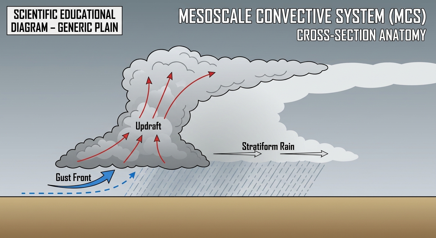
Think of an MCS as a giant, organized cluster of thunderstorms that thrives overnight. It acts like a snowplow, pushing a wall of cold air and damaging wind ahead of it. This complex will likely roll eastward through the night, making it a nocturnal threat for western Oklahoma.
Key Factors to Watch
- Training rain bands: Heavy, repetitive rainfall over the Texas Gulf Coast and eastern Oklahoma today could lead to rapid flash flooding.
- Colorado hail: Afternoon storms initiating off the higher terrain will pose a scattered severe hail threat for eastern Colorado.
- Friday night wind: The transition from isolated supercells to a nocturnal wind threat in the Texas Panhandle and western Oklahoma tomorrow night.
Bottom Line
If you live along the Texas coast or in eastern Oklahoma, keep the umbrella handy and be ready for localized street flooding today. For folks in the Texas Panhandle and western Oklahoma, enjoy the quiet today, but make sure your weather radio has fresh batteries and is turned on before you go to sleep Friday night. The transition to a nighttime wind threat means you need a way to get warnings that will actually wake you up.
https://ryanhallyall.com/blog/a-messy-setup-for-the-southern-plains-and-a-shift-in-the-severe-threat