Blog Article
US Weather Forecast: Ice Storm Threat & Severe Weather Outbreak
A historic temperature divide is sparking a major icing threat for the Mid-Atlantic and severe storms for the Southern Plains. Get the latest forecast details.

A Nation Divided: Ice For The East, Severe Storms For The South, And A Historic Temperature Tug-Of-War
Alright folks, let's talk about what in the world is going on with our atmosphere right now. As we talked about last week when that historic blizzard was locking in over New England, the weather pattern is just completely unhinged.
Get this. Yesterday we saw a 173-degree temperature difference across the United States. Laredo, Texas hit an all-time February record of 103 degrees, while parts of Alaska were sitting at 70 degrees below zero with the wind chill. That is a historic thermal dipole. When you have that much of a temperature clash, the atmosphere has to balance it out. And it usually does that by throwing hazardous weather right at us.
Here is the thing. We have a lot to cover today. We are tracking a sneaky ice storm for the East Coast, the return of severe weather down south, and a massive warmup for the folks up north. Let's dive in.
The Icing Threat: Cold Air Damming Is Back
If you live anywhere from the Central Plains to the Mid-Atlantic, you need to listen up. A strong cold front is pushing across the Northeast and clashing with all that record warmth down south.
Starting today, we are going to see a wintry mix of sleet and freezing rain fire up along the I-70 corridor from northeast Kansas straight through Missouri. The freezing rain amounts here look pretty light, mostly between 0.01 and 0.05 inches. But y'all know it only takes a tiny glaze of ice to turn a highway into a hockey rink.
The bigger problem is going to be out east on Monday and Tuesday. We have a classic "Cold Air Damming" setup coming to the Central Appalachians and the Mid-Atlantic.
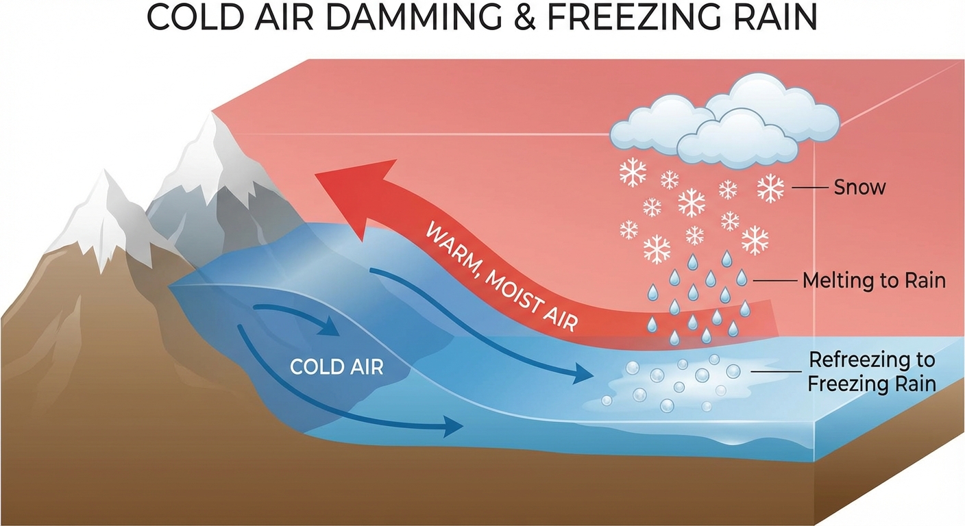
Basically, high pressure to the north is going to lock sub-freezing, heavy cold air against the eastern slopes of the Appalachian mountains. When our next storm system rolls in, the warm moist air will ride right over the top of that trapped cold air. The precipitation falls as rain through the warm layer, but the second it hits the freezing ground, it turns to ice.
The Weather Prediction Center is highlighting a moderate risk for significant ice accretion in the Central Appalachians and the Laurel Highlands of Pennsylvania. We are talking about 0.10 to 0.25 inches of ice. If you live in West Virginia, western Virginia, Maryland, or central PA, you need to plan for a very slick commute early this week. Leave early, take it slow, or just stay home if you can.
Severe Weather Wakes Up In The Plains
Meanwhile, down in the Southern Plains, it feels like we skipped right over spring and landed in summer. But that heat and humidity is going to act like rocket fuel later this week.
We are watching two distinct severe weather threats. The Storm Prediction Center has already issued a 15% risk for severe storms on Wednesday for the Dallas-Fort Worth metroplex, Arlington, and Plano. A cold front is going to slam into that unstable, muggy airmass, and we could see supercells capable of dropping large hail and producing damaging wind gusts.
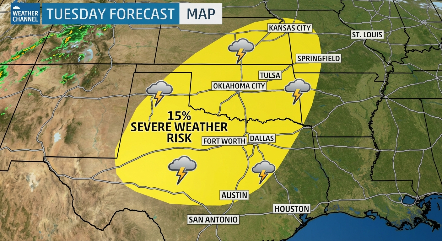
Then, as we head into Friday, another huge upper-level trough moves through the Desert Southwest. This is going to trigger another 15% severe risk covering a massive area, including Dallas, Oklahoma City, Tulsa, and Kansas City.
If you have outdoor plans next weekend, like heading out to the Houston Crawfish Kickoff Festival, you need to keep a very close eye on the forecast. These spring-like setups can change quickly, and we want y'all to stay safe.
Mountain Snow And The Great Northern Thaw
Out west, the active pattern continues. A potent system is digging into the Rockies, and it is going to deliver some fantastic news for the ski resorts. We are looking at a solid 6 to 12 inches of snow for the Wyoming mountains, specifically the Sierra Madre and Snowy ranges. The Colorado Rockies will also pick up a healthy 4 to 10 inches.
But if you live up in the Northern Plains, I have some great news for you. That Arctic air is finally packing its bags. High pressure is moving out, and places like North Dakota and Minnesota are going to see a massive warming trend. Temperatures are going to swing from the deep freeze straight up into the 40s and 50s by midweek. You will be trading your heavy parkas for hoodies, and that recent snowpack from the Alberta Clipper is going to start melting fast.
The Bottom Line
Here is what you actually need to do to prepare for this week:
- Mid-Atlantic & Appalachians: Prepare for a messy, icy Monday and Tuesday. Ice accumulations up to a quarter-inch could cause isolated power outages and treacherous driving conditions.
- Central Plains (KS/MO): Watch out for a light glaze of freezing rain along I-70 today. Bridges and overpasses will freeze first.
- Southern Plains (TX/OK/MO): Have a way to get weather alerts on Wednesday and Friday. Large hail and damaging winds are the main threats. Secure loose items in your yard.
- Northern Plains: Enjoy the thaw. But be mindful of localized pooling of water on the roads as that heavy snowpack begins to melt.
We will keep watching the data and updating you as these systems evolve. Stay safe out there y'all.