Blog Article
MLB All-Star Game Weather in Philadelphia: What to Expect
Baseball's biggest week hits Philly for the All-Star Game. Here's the forecast for game day and where the real severe weather threat is right now.
Baseball's Biggest Week Is in Philly, and the Sky Might Have Something to Say About It
Alright folks, let's talk about the party heading to Philadelphia. The MLB All-Star Game is Tuesday, July 14, and the whole baseball world is pointing at that city. Home Run Derby, the Midsummer Classic, the works.
Here's the thing that makes me a little nervous, and it's got nothing to do with the National League lineup. Philadelphia got roughed up just yesterday. Go back and look at the storm reports from July 11. Large trees uprooted in the Spruce Hill neighborhood. Trees crushing cars in West Philadelphia. A tree down on the Norristown High Speed SEPTA line. There was even a report of tree damage right by the Sports Complex at Broad and Pattison, which is basically the parking lot of where these All-Star festivities live.
So the natural question is: does Philly get hit again for the big game?
The Good News for Tuesday Night
Let me put your mind at ease first, then explain why.
The Storm Prediction Center's outlook does not put Philadelphia in any severe weather risk area for game day. The active severe zones right now sit way south of there, over eastern Georgia and the Carolinas, plus a separate pocket out in Arizona. Philly is not in the crosshairs.
Our own nice-weather crew actually flagged western Pennsylvania and the northern Mid-Atlantic as some of the more pleasant real estate in the country on Monday, with low humidity and near-zero rain chances. That drier, calmer air is the kind of setup you want moving toward a stadium full of people.
July in Philly normally runs about an 87 degree high and a 69 degree low. Ballpark weather, literally. So if you're traveling in for the Derby or the game, pack for warm and muggy, keep an eye on the local forecast the day of, and know that the big organized storm threat is not aimed your way right now.
So Where IS the Weather Happening?
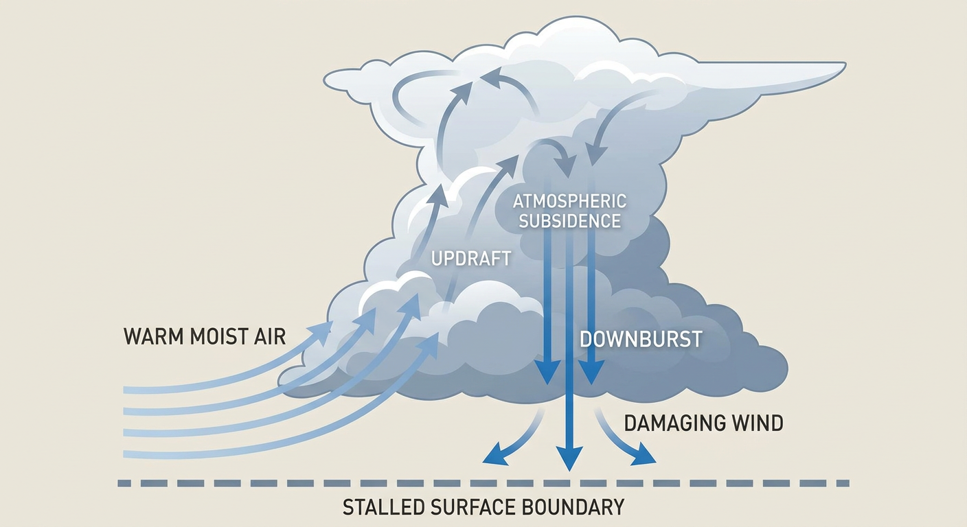
The real story tonight is a stalled boundary draped across the Southeast. Think of it like a fence line that the atmosphere can't decide which side to stand on. It just sits there, and storms keep firing along it afternoon after afternoon.
The SPC has a Slight Risk, that's a Level 2 out of 5, for parts of eastern Georgia into southern North Carolina today, mostly for damaging wind gusts. There's also a Slight Risk down in southern Arizona, where the monsoon keeps cranking. Charleston, Savannah, and Columbia are the cities to watch in the Southeast.
This is the same fence line that lit up Charleston and the South Carolina Lowcountry yesterday. If you scroll through the reports, it's tree after tree after tree down across Charleston County. That boundary hasn't gone anywhere, so today brings another round.
Why Wind, Not Tornadoes?
Good question, and it's the signature of a July setup like this one. Our analog data says it plainly: many July severe events are driven more by damaging straight-line winds than by big tornado outbreaks.
Here's the plain-English version. These summer storms load up with heavy tropical rain. The air up in the storm gets cool and dense, and all that water weight comes crashing down. When it hits the ground it splats and spreads out sideways, and that spreading rush is what snaps trees and knocks out power. Meteorologists call it a wet microburst. It's local, it's fast, and it's exactly what took down those trees in Philly and Charleston yesterday.
The tornado threat today is tiny, just a 2 percent isolated chance in a small area. This is a wind and water story, not a tornado story.
The Rain Threat Shifts to Texas
While the Southeast handles wind, keep an eye on Texas heading into Monday and Tuesday. The Weather Prediction Center has a Slight Risk for excessive rainfall shifting toward Texas and the central Gulf Coast, with the Houston metro on the watch list. Rich tropical moisture, storms training over the same spots, the same flash flood recipe we've seen all month.
And we have seen it all month. July 2026 has been one flood emergency after another, from 12 inches near Oates, Missouri, to 13.5 inches in Polk City, Iowa. Houston doesn't need a repeat, so folks down there should stay plugged into their local warnings.
The Takeaway
The biggest week in baseball looks to be in decent shape in Philadelphia, so if you're headed to the All-Star Game, the sky is more friend than foe right now. The rough weather has moved south to the Carolinas and Georgia and west toward Texas. If you live along that stalled boundary in the Southeast, today's the day to bring in the patio furniture and charge your phone before the evening storms roll through. And if you're in the Houston area, watch the rain the next couple of days.
Different cities, different threats, same summer pattern that just won't quit.