Blog Article
Arizona Enhanced Risk, Tropical System Forming, Aurora Chance
SPC Enhanced Risk hits Arizona with 2-inch hail possible, flash flooding builds for Thursday, a Pacific disturbance nears tropical depression status, and G1 storm may bring aurora.
Enhanced Risk Over Arizona, a Pacific System Trying to Spin Up, and a Shot at Northern Lights Tonight
Alright y'all, there's a lot going on today, so let's get right into it. The headline act is across the Desert Southwest, where SPC has an Enhanced Risk posted for parts of central and northwestern Arizona. But we've also got a tropical system south of Mexico that's about to get a name, a lingering offshore low keeping the Atlantic coast on edge, and a decent chance for aurora up north tonight. Busy day for a mid-October Wednesday.
Tropical Watch: Two Systems, Two Very Different Stories
First, the Eastern Pacific. There's a low-pressure system a few hundred miles south of the Gulf of Tehuantepec (that's Invest 94EP) that NHC says is likely to become a tropical depression within the next day or so. The disturbance desk has it at a 90% chance of development over both the next two days and the next seven, which is about as confident as these outlooks get. It's moving west-northwest around 10 mph and NHC expects it to stay offshore of southern Mexico for now. This basin has been stacked all month, Trudy and Simon both reached major hurricane strength earlier in October, so we'll keep an eye on whatever this one becomes.
Second, out in the Atlantic, that offshore non-tropical low we've been tracking since the weekend (Invest 93AL) is still sitting a few hundred miles off the mid-Atlantic coast, still storm-force with 45 knot winds and a 997 millibar pressure reading. NHC gives it a 40% medium chance of picking up tropical or subtropical characteristics as it slowly loses its frontal features. Named storm or not, this system has already done real damage this week. It's the reason NC 12 got closed between the Marc Basnight Bridge and Rodanthe after the Pea Island dune structure washed out, and Coastal Flood and High Surf Advisories have stretched from New Jersey down through northeastern Florida since Monday. That onshore flow isn't done yet, so if you're anywhere along that stretch of coast, don't be surprised if those advisories get extended again.
The Main Event: Enhanced Risk Along the Mogollon Rim
Here's the big one for today. SPC has an Enhanced Risk up for central and northwestern Arizona, covering Flagstaff, Camp Verde, Payson, and Sedona. That's about 370,000 people sitting in the bullseye. The setup: an upper-level low approaching the California coast is dragging deep moisture and instability up into Arizona, and today's the day it all comes together along the Mogollon Rim.
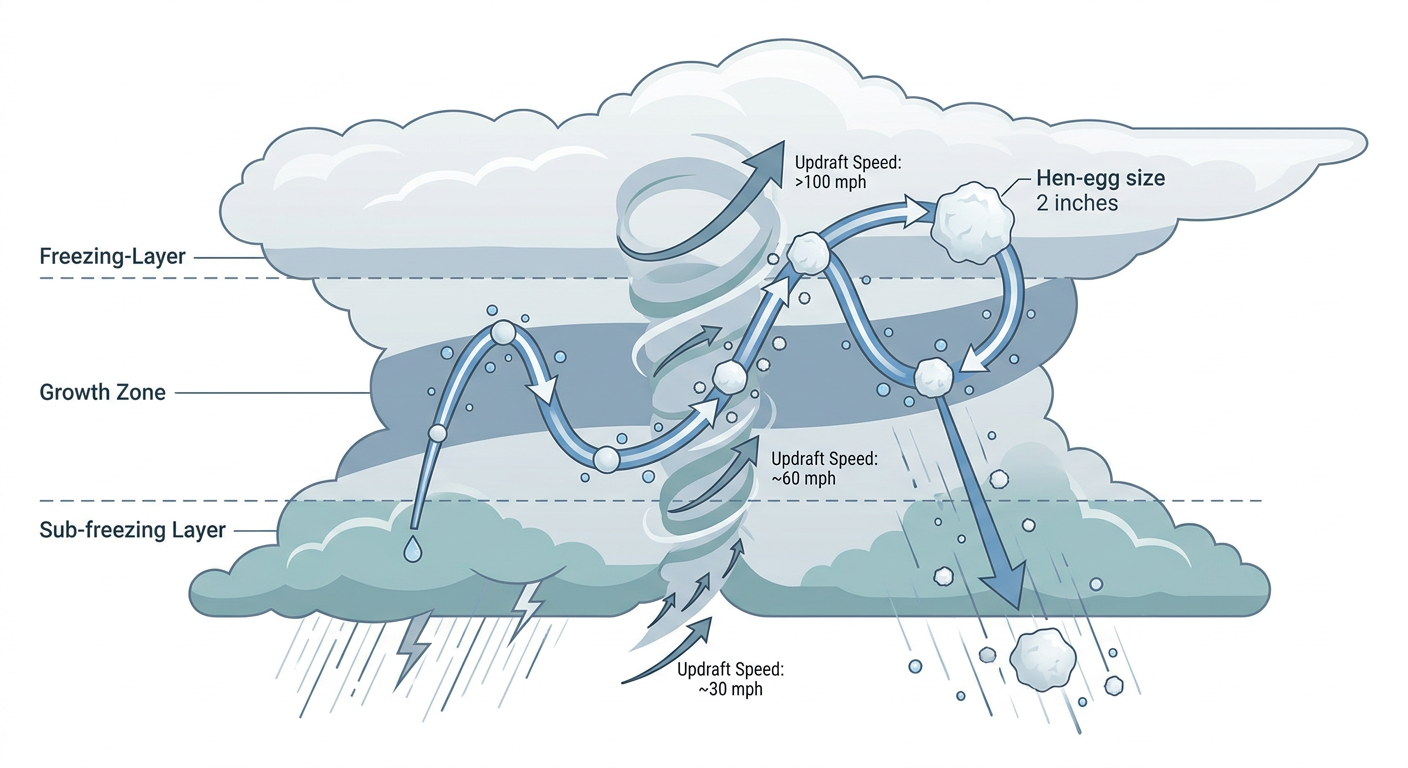
The hail threat is what stands out most. SPC has a 30% probability of numerous severe hail reports, Level 3 on their scale, and inside that area there's a hatched zone where hail could reach 2 inches or more, what they call hen-egg size. That's over 4 million people sitting under that higher-end hail potential. Wind gusts over 60 mph are a scattered threat (15%), and there's a 5% chance of a few tornadoes, which SPC rates Level 2.
A broader Slight Risk covers Globe, Grand Canyon, Mesa, Oracle, and Prescott (about 2.6 million people), and a Marginal Risk stretches all the way to Los Angeles, Phoenix, and Tucson, over 19.5 million people total under some level of severe threat today. This comes on the heels of an already active week in this corner of the country. Just two days ago, a confirmed tornado touched down west of Deming, New Mexico, with a measured 77 mph gust near Rodeo and hail up to 1.75 inches. The pattern hasn't let up, it's just sliding west.
Flash flooding is riding shotgun with the severe threat. WPC has a Marginal excessive rainfall risk over Arizona today, but it's not the rain today you need to worry about most, it's tomorrow. Thursday's Day 2 outlook bumps up to a Slight Risk across the Southwest and Four Corners, including Tucson, Globe, Oracle, and Oro Valley, with hourly rainfall rates that could approach 2.5 inches if storms train or backbuild over the same ground. Local forecasters in Flagstaff, Phoenix, Tucson, and Albuquerque are watching burn scars, dry washes, and urban drainage closely, because that's where flash flooding turns dangerous fast.
Thursday Into Friday: The Risk Slides East, Rain Threat Grows
Thursday's SPC outlook actually eases back from Enhanced to Slight, now centered on central Arizona into far western New Mexico (Tucson, Globe, Oracle, Oro Valley again), with a broad Marginal Risk fanning out across the Four Corners, southern Utah, and into the Great Basin and even touching Salt Lake City and Provo. By Friday, the severe threat has mostly shrunk to a Marginal Risk around El Paso, Albuquerque, Santa Fe, and Alamogordo. The severe weather is calming down day by day, but the rain threat is doing the opposite, the tropical moisture plume feeding this system keeps expanding, so don't let the lower severe category fool you into thinking the flood risk is going away too.
Elsewhere: A Genuinely Nice Stretch for Most of the Country
If you're not in the Southwest, today's actually about as good as October gets. Eastern Montana, western North Dakota, and central South Dakota are sitting under what forecasters are calling a PERFECT-tier airmass today, dry ridge, light wind, dewpoints in the mid-40s. That same dry, clear setup is exactly the kind of night you want for aurora watching (more on that in a second). By Thursday, the nicest weather shifts east into the Ohio Valley and Southeast, with nearly cloud-free skies and comfortable dewpoints. Friday keeps that same Great Lakes and Ohio Valley stretch feeling crisp and clear. Good news if you've got outdoor plans building toward the weekend.
Space Weather: G1 Storm Tonight, Aurora Possible Up North
NOAA's Space Weather Prediction Center says a G1 (Minor) geomagnetic storm is likely today, mainly during the first half of the day, as effects from a coronal hole high-speed stream become geoeffective. Kp values could touch 5. If you're anywhere in the northern tier, especially where skies are already clear tonight (hello, Montana and the Dakotas), it's worth stepping outside after dark and looking north. No guarantees, G1 is a minor storm, but the combination of clear skies and enhanced geomagnetic activity is about as good a setup as you get this time of year for a faint aurora show at higher latitudes.
Key Factors We're Watching
- Hail over 2 inches (hen-egg size) possible today in the Flagstaff-Sedona-Payson corridor under the Enhanced Risk
- Flash flooding ramping up Thursday across Arizona, New Mexico, and the Four Corners as rainfall rates climb toward 2.5 inches per hour
- Invest 94EP's 90% shot at becoming a tropical depression south of Mexico this week
- Invest 93AL keeping Coastal Flood and High Surf Advisories alive from New Jersey to northeast Florida, with more NC 12 overwash possible
- G1 geomagnetic storm tonight, aurora chance for the northern Plains if skies stay clear
Bottom Line
If you're anywhere near Flagstaff, Sedona, Payson, or Camp Verde today, treat this like a real severe weather day. Large hail and a couple of tornadoes are on the table, so keep a way to get warnings and have a plan for sheltering if storms fire up this afternoon. Phoenix, Tucson, and the broader Marginal Risk area should stay weather-aware too, especially into the evening. Tomorrow, the story shifts from wind and hail to water, so if you live near a wash, burn scar, or low-water crossing in Arizona or New Mexico, watch for flash flood warnings Thursday. Folks along the mid-Atlantic and Southeast coast should expect continued coastal flooding and beach erosion risk through the week. And if you're lucky enough to be under clear skies in Montana or the Dakotas tonight, take five minutes and look north, you might catch a little aurora out of this G1 storm.