Blog Article
Fire, Ice & Solar Storms: Wild March Weather Across the US
From record heat and fire danger in the Plains to sneaky freezing rain in the Great Lakes and an atmospheric river out west, here is your weather breakdown.

Alright folks, yesterday we talked about how the weather was throwing curveballs at Spring Training down south. Well today, the atmosphere is just showing off. We've got a little bit of everything on the map. From record-shattering heat in the Plains to a sneaky ice threat in the Great Lakes, and even some space weather sprinkled in. Let's break down exactly what you need to know.
The Heat Dome Expands and Fire Danger Rises
That massive ridge of high pressure that brought 100-degree heat to the Cactus League in Arizona is sliding east. Get this, Denver could hit 82 degrees today, and parts of Oklahoma are staring down 90-degree heat. This is mid-March! If you're heading out to the OUTLAWS & LEGENDS MUSIC FESTIVAL in Texas this weekend, you can definitely leave the jacket at home.
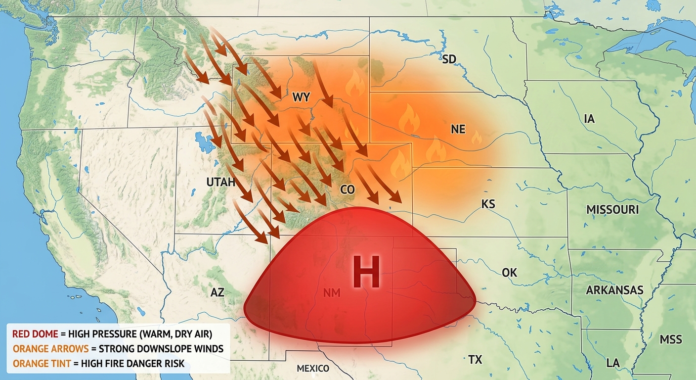
But here's the thing, with that heat comes a serious fire threat. We're looking at Critical Fire Weather today for southeastern Wyoming, western Nebraska, and northern Colorado. The winds are rushing down the Rockies, drying out the air, and turning the high plains into a tinderbox. Please be careful with anything that sparks, folks.
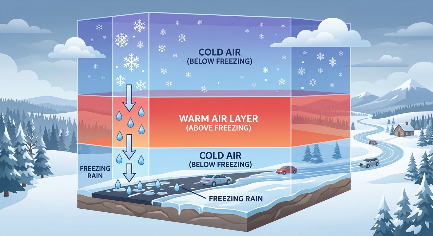
A Sneaky Commute Wrecker in the Great Lakes
While the Plains are baking, folks in the Ohio Valley and Great Lakes are dealing with winter's last gasp. A fast-moving system, called a clipper, is diving out of Canada. By Thursday morning, it's going to drop a nasty mix of freezing rain across southern Michigan, Indiana, and Ohio.
There's a high probability of seeing a glaze of ice right as you're heading out the door for your morning commute. It only takes a tiny bit of ice to turn the roads into a skating rink. If you live in Green Bay, Grand Rapids, or anywhere in that corridor, absolutely leave early tomorrow morning or see if you can work from home until the temperatures warm up.
The Pacific Northwest Just Can't Catch a Break
Out west, the atmospheric river is still pumping moisture into Washington state. We're talking about the potential for up to 9 inches of rain in the Cascades over a 72-hour period. The Weather Prediction Center has a Marginal Risk for excessive rainfall today, tomorrow, and Friday. With all that rain falling on melting snow, we have to keep a close eye on the rivers, especially the Chehalis and Skagit.
Look Up! Space Weather Alert
As if all that terrestrial weather wasn't enough, we have a G2 Moderate Geomagnetic Storm arriving today thanks to a solar flare. What does that mean for you? Well, if you live in the northern tier of the US, keep an eye on the night sky. You might just catch a glimpse of the Northern Lights!
What Y'all Need to Watch
- The Morning Commute: Thursday morning is going to be incredibly slick across Michigan, Indiana, and Ohio.
- Fire Danger: Extreme caution is needed today and tomorrow in Wyoming, Nebraska, and Colorado.
- River Levels: Folks in western Washington need to monitor local flood warnings as the rain keeps falling.
- The Night Sky: Look north tonight if the skies are clear, you might see an aurora.
Bottom Line
The map is lit up like a Christmas tree right now. If you're in the path of that freezing rain tomorrow morning, take it slow and give yourself extra time. For my friends in the Plains, enjoy the early summer weather but respect the fire danger. And for y'all in the Pacific Northwest, keep the rain gear handy, it's not over yet.
https://ryanhallyall.com/blog/fire-ice-and-sunspots-the-atmosphere-is-working-overtime-yall