Blog Article
Flash Flood Risk Shifts East, Utah Fire Danger Spikes
A Slight Risk of excessive rainfall hits the Ozarks and Ohio Valley today while extremely critical fire weather grips Utah and a heat wave builds for the weekend.
Flash Flood Risk Slides East While the Plains Finally Catch a Breather
Alright y'all, if you've been with us this week, you already know the story. June 2026 has been one long parade of training storms, flash floods, and straight-line wind. Overnight it kept right on going. Fire and rescue crews in Wichita were pulling cars out of high water at a dozen intersections after midnight, and over in Wheeler, Texas, floodwater pushed into a nursing home while crews moved residents out.
So here's where things stand this morning, and here's what's actually changed.
Heavy Rain Is Today's Headline
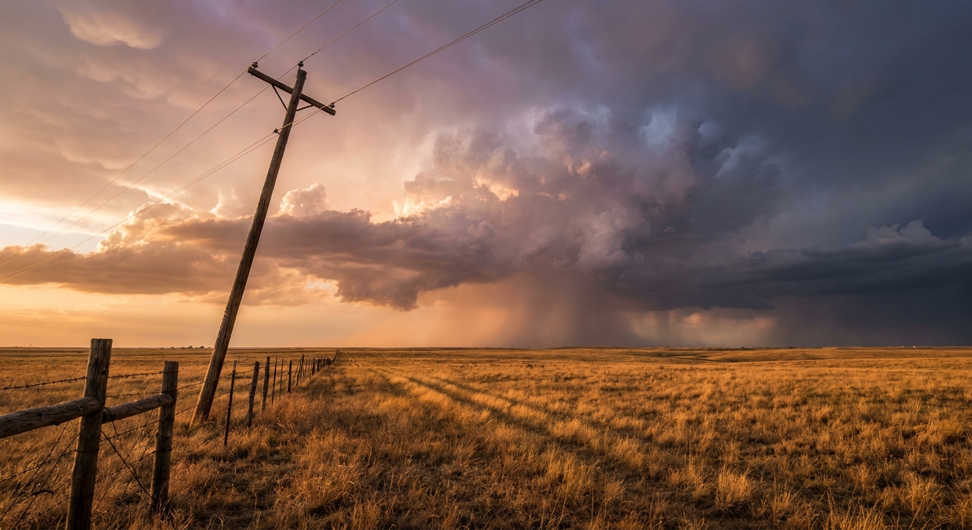
The Weather Prediction Center has a Slight Risk of excessive rainfall posted today, centered from the Ozark Plateau into the lower Ohio Valley. That's the same kind of setup that's been hammering this part of the country for days. A stationary front parked across the region, deep moisture riding along it, and storms that train one after another over the same ground like boxcars on a track.
Here's the thing about training storms. It isn't one big storm that does the damage. It's storm after storm rolling over the same towns, dropping an inch or two each time, until the ground just can't take any more. The grounds across southern Missouri and southeast Kansas are already soaked from yesterday. That's why the flood threat matters even when the rain totals don't sound dramatic on paper.
The SPC also has a Slight Risk for severe storms in two areas: the Ozarks into the lower Ohio Valley, including Louisville and Evansville, and a separate piece across the northern Rockies into the adjacent Plains around Billings. The main concerns are scattered damaging wind gusts to 60 mph and isolated severe hail. There's a low-end tornado threat too, a 5 percent chance in a small zone, which in plain terms means a couple of brief spin-ups are possible if storms get going. Nothing here points to the kind of outbreak we saw earlier this month in southern Illinois.
The broader Marginal Risk stretches a long way, from Philadelphia and Washington down through Nashville and into Oklahoma City. That covers a lot of folks, but a Marginal Risk is the lowest rung on the ladder. It means isolated storms, a stray strong gust, maybe some small hail. Have a way to get weather alerts and go on about your day.
Out West, It's the Opposite Problem
While the middle of the country deals with too much water, Utah and the Great Basin have the opposite trouble. The SPC has an extremely critical fire weather area posted for central Utah into northwest Arizona and extreme southeastern Nevada. That's the top tier they use, and they don't hand it out lightly.
The ingredients are ugly. Southwest winds of 25 to 35 mph with gusts over 45, relative humidity down in the 5 to 15 percent range, and vegetation that's bone dry. Yesterday this same setup earned a Particularly Dangerous Situation Red Flag Warning across most of Utah, and a debris flow buried part of Monroe Canyon Road in mud and boulders. With humidity that low and wind that strong, any fire that starts can move fast. If you're in that zone, this is a no-burn, no-sparks kind of day.
Salt Lake City sits right on the edge of the critical area. For context, the average June high there is 85 degrees, and the dry, windy pattern fits the picture.
A Heat Wave Is Building for the Weekend
Look a few days out and the bigger pattern shift shows up. The Climate Prediction Center is flagging a building heat wave across the central and eastern US for this weekend into early next week, driven by an amplifying upper ridge. Dewpoints climb into the low to mid 70s along the Gulf Coast and Great Lakes, which is the sticky, oppressive kind of humid that makes 90 feel like 100.
That matters for the long list of outdoor plans this weekend. The Reds and Pirates play in Pittsburgh tonight, the Phillies are at the Mets in Queens, and there's festival traffic all over: Hampton Jazz in Virginia, Breakaway in St. Paul, Hoofbeat Country Fest in Wisconsin. Most of those sit under that Marginal severe risk today and then under the heat dome this weekend. If you're heading to any of them, the heat is the bigger story than the storms by Saturday and Sunday. Bring water, find shade, and pace yourself.
The one pocket of genuinely pleasant weather sits up north. The upper Great Lakes from Green Bay to Marquette get a Canadian high pressure ridge tomorrow, with highs in the mid 70s and low humidity. Minneapolis, sitting near a June average high of 79, lands on the comfortable side of the map before the heat tries to creep north.
What I'm Watching
- Training storms over the Ozarks and lower Ohio Valley. Saturated ground means even moderate rain can flood roads fast. This is the day's top hazard.
- The Utah and Great Basin fire weather. Extremely critical conditions, the highest category SPC uses. New fire starts could spread quickly.
- The weekend heat build. Highs and humidity climbing across the central and eastern US. Heat stress becomes the main concern for anyone outdoors.
- Day 2 severe in eastern Montana and the Mid-Atlantic. A Slight Risk shifts to those areas Saturday, with a hatched zone for 75 mph gusts and 2-inch hail in the northern Plains.
Bottom Line
If you're in southern Missouri, southeast Kansas, or the lower Ohio Valley, watch the roads today. Turn around, don't drown, and don't drive into water you can't judge the depth of. If you're in Utah or the Great Basin, treat today as a high fire danger day and skip anything that throws a spark. And if you've got weekend plans anywhere in the central or eastern US, start prepping for heat, because that ridge is on the way and the humidity is coming with it.
https://ryanhallyall.com/blog/flash-flood-risk-slides-east-while-the-plains-finally-catch-a-breather