Blog Article
Flash Floods, 75 MPH Winds, and a Solar Storm Today
A volatile Friday brings 75 mph wind gusts and flash flooding to the Midwest, while a severe geomagnetic storm could light up the night sky with auroras.

Flash Floods, 75 MPH Winds, and a Major Solar Storm Today
We talked yesterday about the massive wind threat setting up across the Midwest. Well folks, moving day is here. The atmosphere is primed, the moisture is in place, and we have a very busy Friday ahead of us.
We are tracking a multi-hazard setup today. We have severe thunderstorms in the Plains, a growing flash flood threat, and a major space weather event that could put on a show tonight if the clouds clear out.
The Midwest Severe Threat
The Storm Prediction Center has a Slight Risk in place today from eastern Nebraska through Iowa and into northern Illinois. That includes Omaha, Des Moines, and the western Chicago suburbs.
The main hazards are straight-line winds and large hail. There is a specific hatched area for winds where gusts could top 75 mph. We are also watching a hatched area for hail where stones could reach two inches in diameter. That is hen-egg size, and it will absolutely dent a car or damage a roof.
If you have tickets to see the Giants play the Cubs at Wrigley Field this afternoon, or if you are heading to the White Sox game in Philly tonight, you need to keep an eye on the radar. Those bleachers empty out fast when the lightning starts, and you do not want to be caught in a crowd when a 60 mph gust hits.
The Water Problem
We also have a serious water problem developing. The Weather Prediction Center has outlined a Slight Risk for excessive rainfall across eastern Nebraska, Kansas, and the Mid-Mississippi Valley. Down south, parts of Texas and southern Oklahoma are in the same boat.
Yesterday, parts of Kansas picked up over 5 inches of rain. The ground is completely saturated. When storms move over the exact same areas today, that water has nowhere to go but into the streets and creeks.
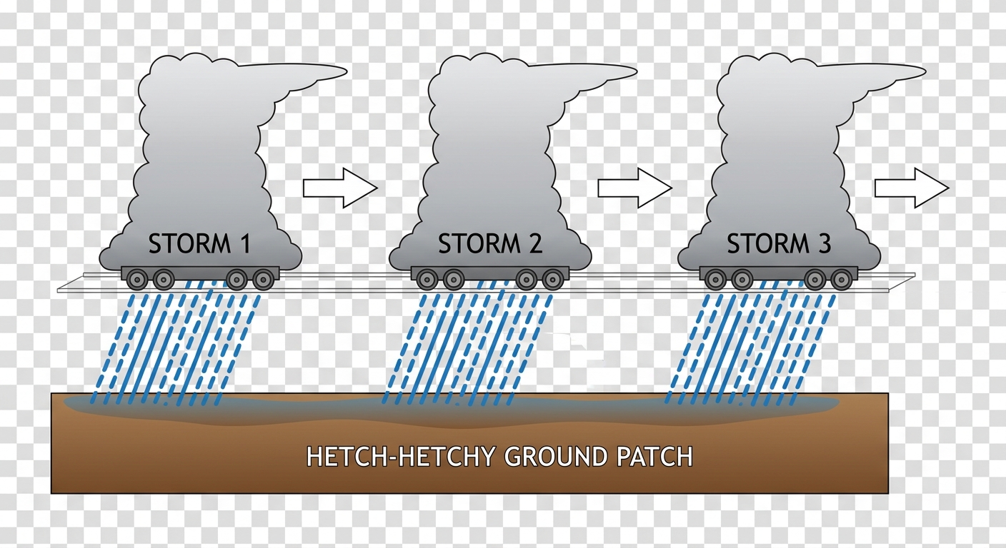
This happens due to a process called training. Just like train cars rolling down a track, these thunderstorms follow the exact same path one after another. It is a classic recipe for flash flooding.
Look Up Tonight
Now for the wild card. The Space Weather Prediction Center is tracking a major event. A series of Coronal Mass Ejections left the sun a couple of days ago, and they are arriving today.
NOAA is forecasting G3 to potentially G4 geomagnetic storming. A G4 storm is considered severe. This means the solar wind is aggressively interacting with Earth's magnetic field.
What does this mean for you? If the skies clear out behind the storms tonight, folks in the northern half of the country might get a spectacular view of the Northern Lights.
The Weekend Shift
As we head into Saturday, the severe threat shifts east toward the Ohio Valley and Northeast. Places like Columbus, Cleveland, and Pittsburgh are in a Day 2 Slight Risk for large hail and damaging winds. If you are heading to the Governors Ball in Queens this weekend, be aware that the New York area is sitting in a Marginal Risk for some gusty storms.
Meanwhile, out West, a Critical Fire Weather area is in place for the Great Basin and Southwest. Bone-dry air and 20 to 30 mph winds mean any spark could start a major wildfire across Nevada, Utah, and Arizona.
Bottom Line:
Have multiple ways to get warnings today, especially if you live in the Midwest or Central Plains. Keep your phone charged and the volume up. If you encounter a flooded road on your commute home, turn around. It is never worth the risk to test the depth of the water.
https://ryanhallyall.com/blog/flash-floods-75-mph-winds-and-a-major-solar-storm-today