Blog Article
Flood Risk From Kentucky to the Carolinas, Heat Out West
A slow-moving upper low brings a flash flood risk from Kentucky and Tennessee into the Carolinas July 12, with damaging winds and dangerous heat out West.

Flood Watch Central: Rain Sets Up Over Kentucky, Tennessee and the Carolinas While Texas Loads for Later
Alright y'all, we need to talk about water. Not the fun kind you jump into on a July afternoon. The kind that fills up creeks and covers roads and traps campers.
You saw the news out of Missouri and Kentucky. Around 200 young campers had to be rescued as flooding hit those areas. That's not an abstract headline for us. It's the same pattern we've been living with all month, and it's not done yet.
Today, July 12, the Weather Prediction Center has a Slight Risk of excessive rainfall posted from parts of Kentucky and Tennessee into southern Virginia and the Carolinas. That's the headline. Let's get into why.
Why This Rain Keeps Piling Up
Here's the thing. A mid-level shortwave feature has wound itself up into a deeper closed low sitting over the region. A closed low is basically a spinning pocket of energy that gets cut off from the main flow, so it just sits and spins instead of moving along.
When that happens, the storms it makes move slow. And slow storms are the problem. Rain that would be no big deal spread over a few counties becomes a real hazard when it dumps on the same ground for hours.
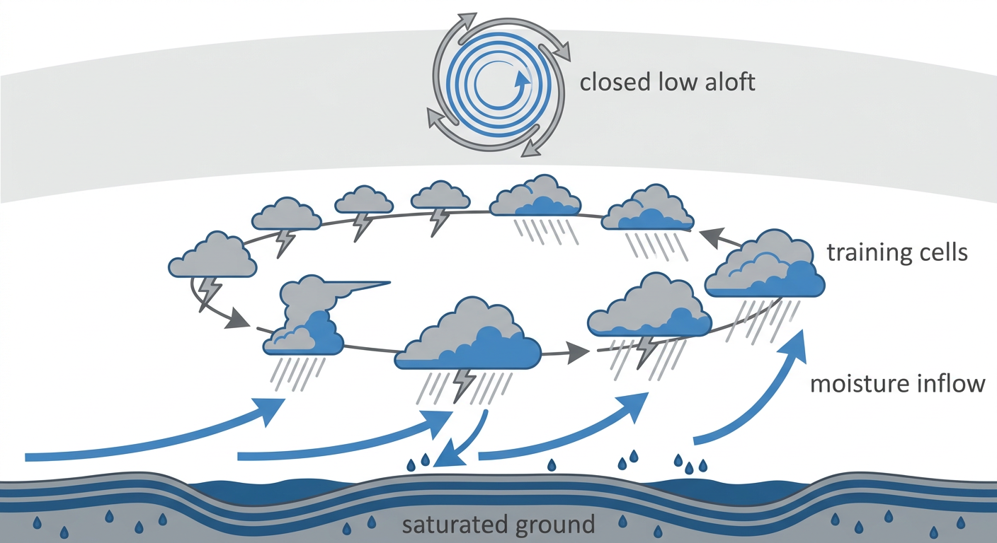
And remember what the ground already looks like. This week alone we watched 12.25 inches fall near Oates, Missouri, with a Particularly Dangerous Situation flood emergency. Earlier in the month Polk City, Iowa picked up 13.5 inches in 24 hours. Kelleys Island, Ohio saw reports up to 14 inches. When soil is already wet, it can't soak up much more. The rest runs off fast.
The good news, if we can call it that: forecasters do not expect widespread organized rainfall today. This is more of a scattered, localized flash flood setup. But localized doesn't mean harmless. It means you might be fine while the next town over is dealing with water over the road.
The Severe Side: Mostly A Wind Story
SPC has a Slight Risk for severe storms across the Carolinas, eastern Georgia, and southern Arizona today. The main threat is damaging wind gusts. There's a Level 2 of 5 wind area covering about 18 million people, including Charlotte, Raleigh, Charleston, and down into southern Arizona around Phoenix and Tucson.
We saw exactly this play out yesterday. Charleston County alone racked up dozens of trees-down reports. Gainesville, Florida measured a 78 mph gust. And out in the desert, Tucson clocked an 81 mph gust earlier in the week from monsoon storms. July in this part of the country shifts from tornado season into damaging-wind season, and that's the flavor we're tasting.
The tornado threat is low, a 2 percent area, meaning if a storm does get going an isolated brief tornado isn't impossible. Hail stays isolated too. This is a wind and water day, not a tornado day.
Key Things I'm Watching
- Flash flooding across Kentucky, Tennessee, southern Virginia, and the Carolinas on ground that's already soaked
- Damaging wind gusts to 60+ mph in the Carolinas and eastern Georgia if storms organize this afternoon
- Monsoon outflow winds in southern Arizona, the kind that produced 80+ mph gusts this week
- Dangerous heat from Montana into North Dakota, with highs of 100 to 110 degrees and Billings challenging records
- Critical fire weather in southern Montana into Idaho and northern Wyoming, where humidity drops into single digits
The Southwest And The Heat Dome
That big ridge we talked about yesterday is still parked over the northern High Plains, and it's doing the same two jobs. Underneath it, the air sinks and bakes. Billings and Glasgow, Montana are looking at highs 15 to 25 degrees above their mid-July normals. That's dangerous heat, plain and simple.
The dry, hot, windy combo also lights up the fire risk. SPC has a Critical fire weather area for southern Montana into Idaho and northern Wyoming, with relative humidity dropping to 5 to 10 percent and gusty winds around a deepening surface low. If you're out that way, be careful with anything that throws a spark.
Looking Ahead To Texas
Don't tune out the flood story after today. The WPC keeps a Slight Risk going for excessive rainfall into Texas and the central Gulf Coast on Monday and central Texas again Tuesday. The setup there is backbuilding and training storms over the Edwards Plateau and Hill Country, which is flash flood alley when the ingredients line up. We'll keep an eye on it.
Sports And Events Weather
A lot going on outside today. The Braves are at St. Louis, the Cubs at Cincinnati, and the Phillies at Detroit. Those Midwest and Ohio Valley games sit near the northern edge of the wet pattern, so a passing storm delay is possible but not a lock.
The closer watch is the Southeast. Any outdoor plans across the Carolinas and eastern Georgia should have a way to get indoors fast if a storm rolls up. Those storms move quick and the wind is the part that hurts you.
And looking to the week, the MLB All-Star Game is Tuesday in Philadelphia and the World Cup Final lands at MetLife in New Jersey on July 19. The Mid-Atlantic shows up in the extended severe outlook with a 15 percent area around the I-95 corridor for later this week, so we'll be tracking that as the Final gets closer.
Bottom Line
If you're in Kentucky, Tennessee, southern Virginia, or the Carolinas today, the water is the thing to respect. Never drive through a flooded road. You cannot tell how deep it is or whether the road under it is still there. If you're in the Carolinas or eastern Georgia this afternoon, keep a way to get inside quick when storms fire, because the wind can drop trees in a hurry. Out in the northern High Plains, treat the heat like the hazard it is: hydrate, check on older neighbors, and don't leave anyone in a hot car. Everybody else, enjoy the ballgame and keep half an eye on the sky.