Blog Article
Hurricane Polo Cat 5 and NM Flood Risk: Sept 22 Weather
A real Category 5 hurricane spins in the Pacific while New Mexico faces a Moderate flood risk ahead of Albuquerque's Balloon Fiesta season. Here's what matters.

Forget the DQ Blizzard, Y'all. There's an Actual Category 5 Spinning in the Pacific
Alright, so "blizzard" is trending today, and it's got nothing to do with snow. Dairy Queen and Oreo just announced a new ice cream mashup, and the internet did what the internet does. Get this, though. While y'all are Googling ice cream, there's a word that meteorologists don't throw around lightly, and it's happening for real right now: Category 5.
The actual Category 5, no marketing involved
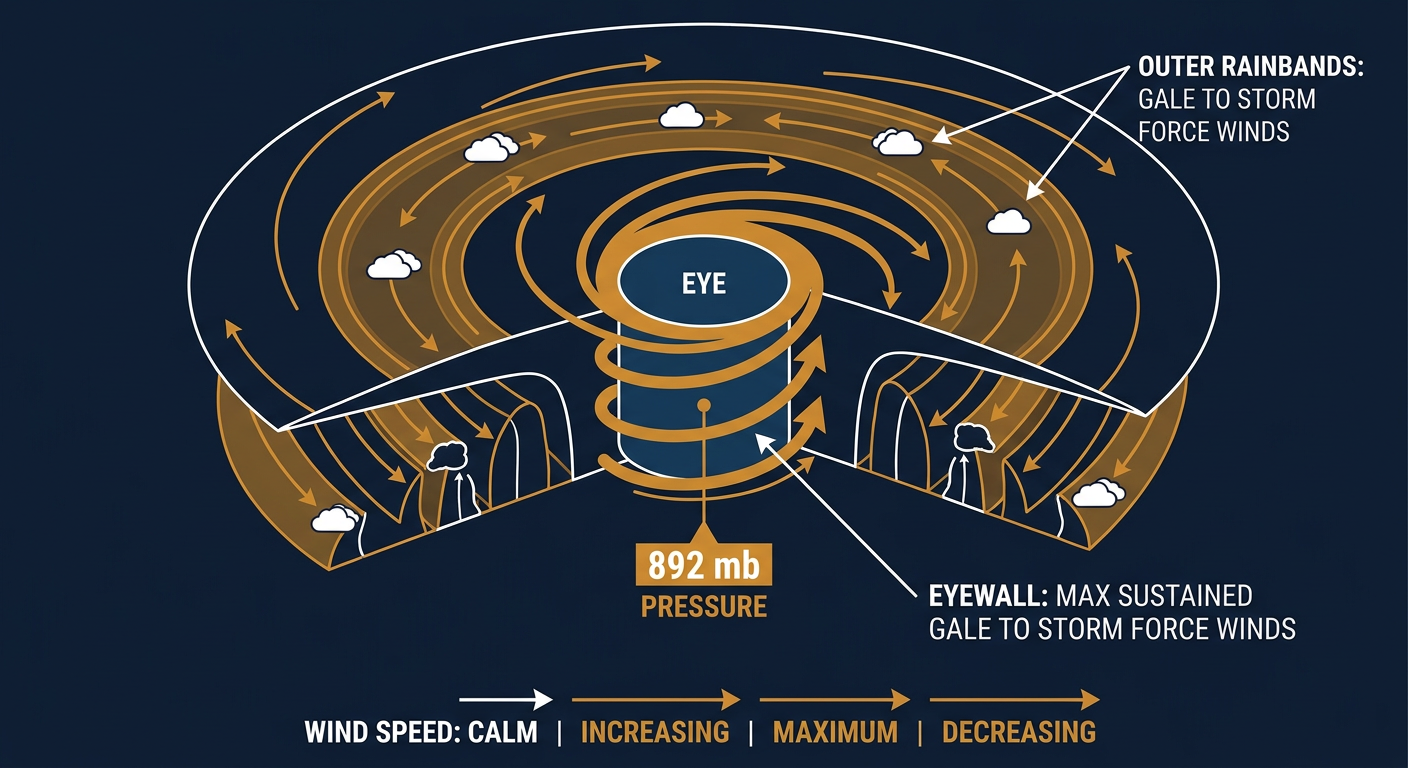
Hurricane Polo is sitting a couple hundred miles south-southeast of Manzanillo, Mexico, and it is an extremely dangerous Category 5 hurricane. We're talking 178 mph sustained winds and a central pressure of 892 millibars. For context, that pressure reading is about as low as hurricanes get. Lower pressure means a more violently spinning storm, and 892 mb puts Polo in rare company.
Hurricane Hunters flew through it today and confirmed just how intense this thing is. The storm is essentially stationary right now, parked a couple hundred miles off the Mexican coast, and NHC expects it to stay at Category 5 strength for the next couple of days before it starts to weaken as it tracks northwest over open water. Current guidance keeps Polo offshore, with no landfall forecast, though its closest approach to land later this week could still bring dangerous surf and swells to parts of the Mexican coast.
Polo isn't traveling alone out there, either. Tropical Storm Odalys is spinning well out in the open Pacific with 70 mph winds, drifting slowly and posing no threat to land. And way out in the Atlantic, what's left of Fay has weakened to a remnant low, mostly just clouds and a memory of a storm at this point.
There's also a system worth watching southeast of Hawaii. NHC has it at a 70 percent chance of development over the next two days and 90 percent over seven, which is a HIGH risk category. That's the same general neighborhood where Hurricane Lowell buzzed Kauai as a Category 2 back on September 7 and 8, knocking out power to more than 33,000 customers. Honolulu's forecast office is watching this one closely, and if you've got Hawaii travel plans in the next week, keep an eye on it.
The rain that actually affects your plans: New Mexico
Here's the story that matters if you live anywhere near Albuquerque or El Paso. The Weather Prediction Center has a Moderate Risk of excessive rainfall in place today and tomorrow across central and eastern New Mexico. That's WPC's second-highest category, and it doesn't get issued lightly.
What's driving it: near-record precipitable water values, meaning the atmosphere overhead is about as saturated as it gets this time of year, combined with easterly upslope flow and a mid-level shortwave lifting north through the state. Add daytime heating on top of that moisture, and you get thunderstorms that train, meaning they line up and repeat over the same spots instead of moving through. That's how you go from a normal monsoon shower to two to four inches of rain, with isolated totals near or above five inches.
The real danger isn't just standing water. It's flash flooding and debris flows on the Sacramento Mountains burn scars, plus the arroyos and normally dry washes across the Albuquerque and El Paso areas that turn into moving water in a hurry when rain rates spike. If you live in that corridor, know your route out of a low spot before you need it.
Here's the cultural wrinkle. Albuquerque's biggest weekend of the year, the International Balloon Fiesta, kicks off October 3. That's still about two weeks out, so nobody can tell you what the skies will look like for launch morning. But this week's soaking is a reminder of just how unsettled New Mexico's monsoon pattern has been all season, and saturated ground plus a busy weather pattern is exactly the kind of thing Fiesta organizers watch closely as the calendar creeps closer.
The rain threat doesn't stop at the New Mexico line either. WPC has a Slight Risk extending into the Texas Panhandle by Thursday, and a separate Slight Risk band stretches from eastern Tennessee through eastern Kentucky and southern West Virginia, an area that's already seen its share of flash flooding this month.
The rest of today's board
- SPC has a Marginal severe risk today for parts of Utah into southwest Wyoming and western Colorado, plus another Marginal area across the Southeast including Atlanta, Charlotte, Birmingham, and Huntsville. Isolated damaging gusts are the main concern in both zones.
- Wednesday brings a Marginal severe risk to eastern Tennessee, including Knoxville and Chattanooga, where a reinforcing shortwave could support brief hail and wind.
- Space weather watchers should mark September 25 on the calendar. NOAA's outlook calls for a G1 (Minor) geomagnetic storm that day, driven by a coronal hole high-speed stream. It's a modest event, so if you're at Oceans Calling in Ocean City or All Things Go in Columbia that weekend, don't expect aurora over the festival grounds. G1 storms typically only light up the sky at much higher latitudes.
- If you want the calm, pretty weather day this week, look toward the Upper Midwest and Great Lakes. A dry Canadian high is delivering genuinely gorgeous conditions there Tuesday into Wednesday, the kind of crisp, clear-sky setup that doesn't come around often this time of year.
The takeaway
Words matter in this business. "Blizzard" sells ice cream. "Category 5" means 892 millibars of pressure and winds that can flatten a coastline. "Moderate Risk" from WPC means life-threatening flash flooding is a real possibility, not just a rainy inconvenience. Enjoy the ice cream pun if you want, but if you're anywhere near Albuquerque or El Paso this week, treat the real word of the day with the respect it deserves.