Blog Article
July 4th Storm Threat Shifts East, Plus G2 Aurora Chance
Enhanced Risk severe storms hit the Upper Midwest today as the Fourth of July threat slides into the Mid-Atlantic. Plus a G2 geomagnetic storm and aurora chance Friday.

Fourth of July Storm Chances Slide East: Severe Weather, Heavy Rain, and a G2 Aurora Curveball
Alright y'all, we talked yesterday about how this pattern wasn't done with the Upper Midwest. It isn't. But here's what's changed. The severe threat is about to start shifting east, right toward the folks with the biggest Fourth of July plans, and there's a space weather wrinkle worth watching too.
Let's start where the action is today, then walk it forward to the holiday.
Today: the Upper Midwest is back in the bullseye
The Storm Prediction Center has an Enhanced Risk, Level 3 out of 5, drawn across the northern Plains into the Upper Midwest. Sioux Falls, Marshall, Montevideo, and Morris, Minnesota sit right inside it. Around 775,000 people are in that core zone.
The headline threat is wind. There's a 30% chance of damaging gusts near the center of that Enhanced area, and the hatched zone means the strongest gusts could top 75 mph. That's the numerous damaging wind category, so this isn't a stray storm or two. This is organized.
A broader Slight Risk wraps around it, covering Minneapolis, Milwaukee, Madison, Des Moines, and even down into the southern Appalachians around Atlanta. Quarter-size hail and isolated tornadoes round out the threat. The tornado probability is low, 2%, but northern Iowa proved just last night that July tornadoes are real. Spotters caught brief touchdowns near Oto and Stacyville, Iowa overnight.
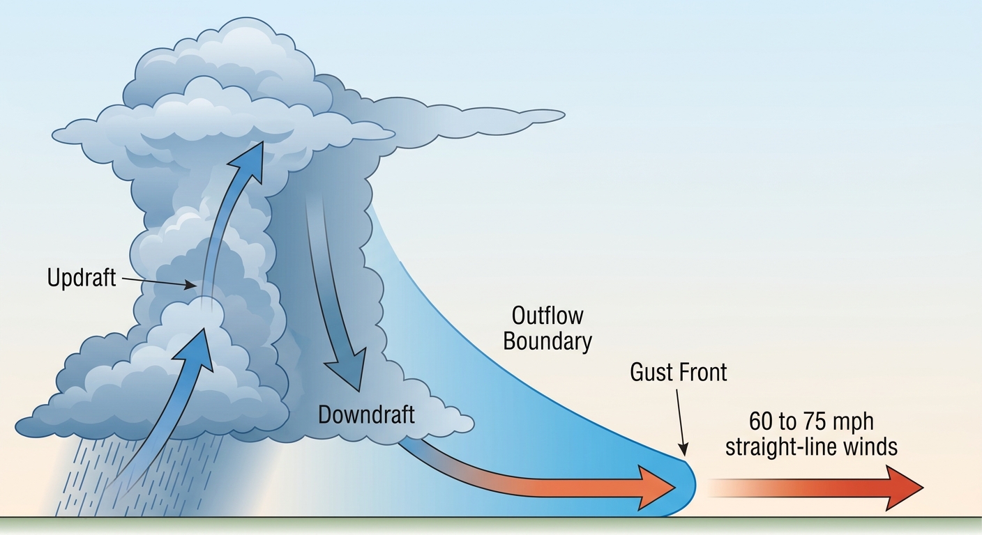
Here's why the wind keeps being the story. When these storms cluster up, they form what we call a mesoscale convective system, an MCS. Think of it as one big, self-feeding blob of thunderstorms that rolls along a stalled front, dumping cold air out ahead of it and using that outflow to keep new storms firing.
Summerfest note: Weekend 3 is cranking on the Milwaukee lakefront. Milwaukee's in that Slight Risk today. Outdoor stages and big crowds don't mix well with sudden wind, so if you're on the grounds, keep your phone handy for warnings.
Heavy rain keeps piling up over the same ground
The Weather Prediction Center has a Slight Risk of excessive rainfall over the northern Plains and Upper Midwest today, then again Friday into the western Great Lakes. Precipitable water values are running 1.5 to 2 inches, which is a lot of moisture to wring out.
The problem is repetition. This same corridor got 3.5 inches in Winona County, Minnesota earlier this week, and the ground's already taken a beating. When storms train over saturated soil, it doesn't take much to get water moving fast. Localized flooding is the concern, especially where storms park.
The Fourth of July: the threat moves to the Mid-Atlantic
Here's the shift I mentioned. By Saturday, the Fourth, the severe focus swings to the Mid-Atlantic. SPC has a Slight Risk posted from New York down through Philadelphia, Baltimore, Washington, and into Virginia Beach.
The ingredient list is heat and moisture. We're talking a very muggy airmass with afternoon temperatures pushing near 100 degrees. For reference, Washington's normal July high is 89 and Philadelphia's is 87, so we're running roughly 10 degrees above normal with heat indices climbing higher than that. That kind of heat cooks up plenty of instability. Shear is on the weaker side, but there's enough mid-level flow, around 30 knots, to organize clusters of storms that can produce damaging wind gusts.
That matters for a packed holiday calendar out East:
- National Independence Day Parade in Washington, DC
- Nathan's Hot Dog Eating Contest in Brooklyn
- Peachtree Road Race with 60,000 runners in Atlanta (in that southern Slight Risk zone earlier in the weekend)
- Pirates at Nationals in DC and Twins at Yankees in the Bronx, both outdoor ballparks
Afternoon and evening are when these storms tend to fire, which is prime cookout and fireworks time. If you've got outdoor plans on the Fourth in the Mid-Atlantic, have a backup and know where you'll go if the sky turns.
The space weather curveball: possible G2 aurora Friday night
Here's something a little different. NOAA's Space Weather Prediction Center says a coronal mass ejection, a CME, that left the sun on June 30th should arrive early Friday, July 3rd. That's expected to kick up G2, moderate, geomagnetic storm conditions.
In plain terms, a big burst of charged particles from the sun is headed our way and will rattle Earth's magnetic field. G2 is moderate, not a monster, but it can push the northern lights farther south than usual. If skies clear across the northern tier Friday night, folks up north might catch a glimpse. There's timing uncertainty, and an arrival late on the 2nd can't be ruled out, so it's a watch-and-see, not a guarantee.
The West stays hot and dry
Don't forget the Four Corners. SPC has a Critical Fire Weather area up again today for western and southern Colorado, eastern Utah, and northern New Mexico. Grand Junction, Pueblo, and Montrose are in it. Relative humidity dropping into the single digits with gusty southwest winds keeps fire danger high, and this is the second straight day for that setup. If you're in that country, be careful with anything that sparks.
What I'm watching
- Today's MCS in the Upper Midwest. Wind is the main hazard, with 75+ mph gusts possible near Sioux Falls and southwest Minnesota.
- Repeat heavy rain over already-soaked northern Plains and Upper Midwest ground.
- Saturday's Mid-Atlantic setup, where near-100 heat feeds afternoon storms right into holiday plans.
- The CME arrival Friday and whether G2 conditions light up the northern sky.
- Ongoing Four Corners fire weather for a second day running.
Bottom Line
If you're in the Upper Midwest today, treat this like a wind day. Bring in loose stuff, charge your phone, and have a plan if a warning drops. If your Fourth of July is in the Mid-Atlantic, expect heat near 100 and plan around afternoon and evening storms. Have an indoor fallback for the parade, the ballgame, or the cookout. And if you're up north Friday night with clear skies, look up. That aurora chance is a fun bonus in a week that's been all business.