Blog Article
Friday Severe Weather: 75 MPH Winds Target the Midwest
A severe weather setup threatens the Midwest on Friday with 75 mph wind gusts, hen-egg-sized hail, and flash flooding. See how it impacts weekend plans.

Friday Night Fastballs and 75 MPH Gusts: The Midwest Wind Threat
Get this, y'all. If you have tickets to see the Giants play the Cubs at Wrigley Field tomorrow afternoon, or if you are heading up to Minneapolis to watch the Royals and Twins under the Friday night lights, you might want to keep a close eye on the sky. We are tracking a weather setup that could clear the bleachers faster than a rain delay.
The Storm Prediction Center has issued a Slight Risk for severe thunderstorms on Friday across a large chunk of the Midwest. The primary target area includes eastern Nebraska, Iowa, southeast Minnesota, and western Wisconsin.
The Fuel Behind the Storms
The atmosphere is packing a massive amount of potential energy tomorrow. Meteorologists measure this energy using something called CAPE, which stands for Convective Available Potential Energy. Think of CAPE like the octane rating in gasoline. Tomorrow, the weather models are showing CAPE values soaring over 3,000 Joules per kilogram. In plain English, the atmosphere has a full tank of premium fuel.
When Friday's storms tap into that fuel, they are going to grow incredibly tall and hit hard. The main hazard we are tracking is straight-line wind. There is a specific hatched area inside the risk zone, particularly over Iowa and eastern Nebraska, where wind gusts could reach 75 mph or higher. That is hurricane-force wind coming out of a severe thunderstorm. It is enough to snap tree branches, knock down power lines, and make driving on Interstate 80 downright dangerous.
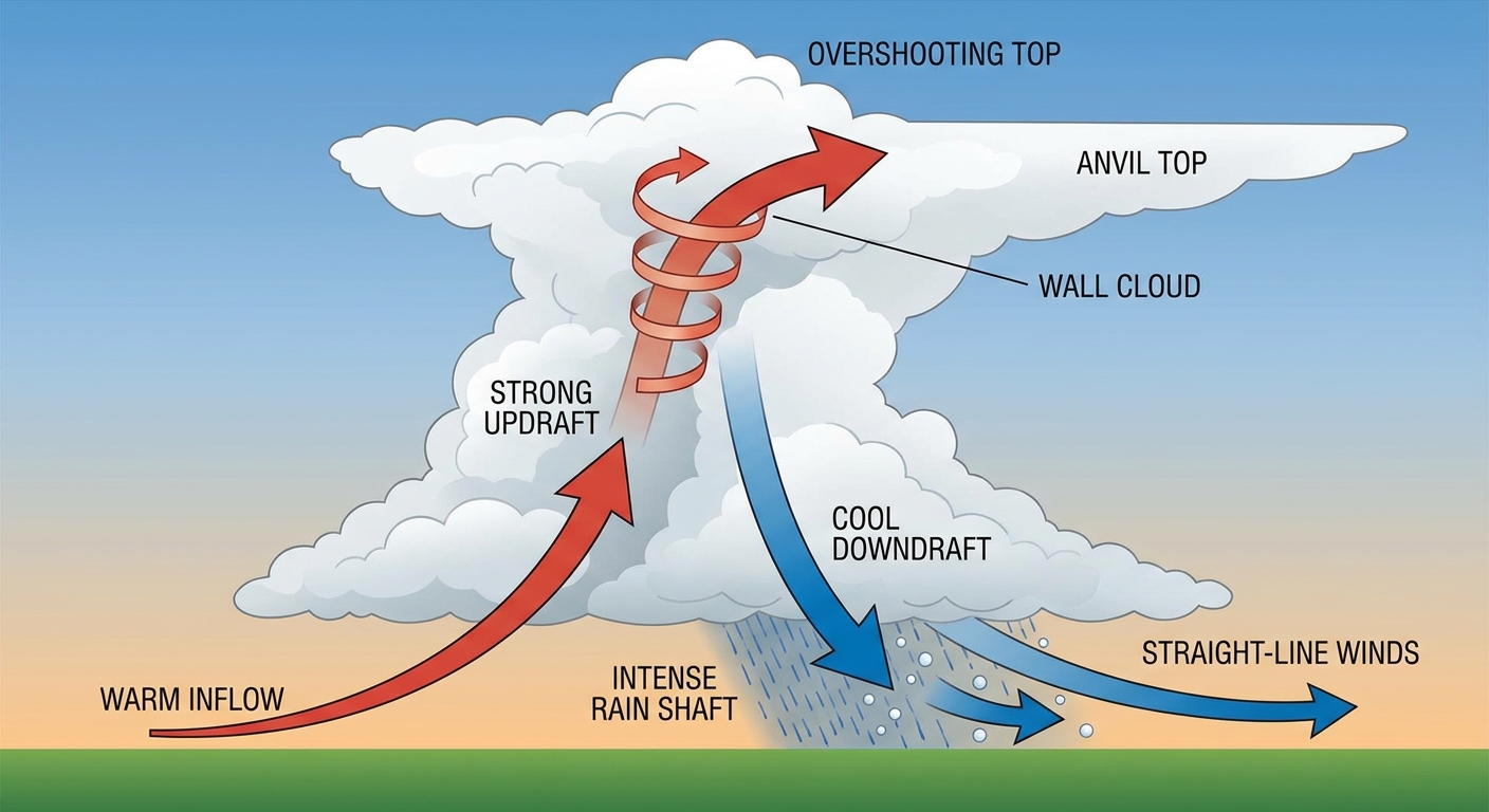
We are also looking at a significant threat for large hail. Inside that same hatched area, some of these storms could drop hailstones over two inches in diameter. That is hen-egg size. If you park your car outside, you will want to find a garage or carport before the afternoon rolls around.
The Water Problem
On top of the wind and hail, we have to talk about the rain. The Weather Prediction Center has highlighted a Slight Risk for excessive rainfall across eastern Nebraska and right into the Mid-Mississippi Valley.
The data suggests these storms might start training over the same areas. That means one storm follows right behind another, dumping heavy rain on ground that is already saturated. We could see localized rainfall totals around four inches. That much water falling that quickly will overwhelm drainage systems and cause flash flooding, especially in urban areas and low-lying roads.
A Quick Look at the Tropics
Shifting our focus down south, the Eastern Pacific is waking up. Tropical Storm Amanda is currently spinning about 1,500 miles west-southwest of Baja California. Amanda has sustained winds around 45 mph and is moving west-northwest into open water.
Amanda is not a threat to the United States. However, we are watching two other disturbances much closer to the coast of Central America and southern Mexico. Both of these areas of low pressure have a high probability of developing into tropical depressions over the next week. The National Hurricane Center gives them a 70 and 80 percent chance of formation, respectively.
If your Friday plans include an outdoor event in the Midwest, make sure you have a reliable way to get weather alerts. The radar will look messy by tomorrow evening, and you need to know exactly where your safe shelter is located before the wind arrives.
https://ryanhallyall.com/blog/friday-night-fastballs-and-75-mph-gusts-the-midwest-wind-threat