Blog Article
Severe Storms Shift East as Critical Fire Threat Builds
Track the latest forecast as severe storms move to the East Coast, critical fire weather hits the Plains, and blizzards hammer the Pacific Northwest.

Alright folks, let's get right into it.
Man, yesterday was something else. As we talked about in our last post, that polar vortex split really set the stage for a violent Tuesday. We saw literal grapefruit-sized hail in Illinois and some terrifying tornadoes in Indiana. If you were in the path of those storms, I hope y'all are safe and sound and recovering today.
But here is the thing about a storm system this massive. It does not just stop. It keeps on rolling, and the hazards are changing as it moves.
The Threat Moves East and South
Today, that massive cold front is marching east and south. We have a Slight Risk for severe storms stretching across a huge chunk of real estate, from Houston up through Memphis, Indianapolis, Columbus, and all the way over to Philadelphia.
If you live in these areas, you need to keep your weather radio handy today. The main threats are going to be damaging winds and isolated tornadoes.
Down south, we are also watching a serious water problem. There is a Slight Risk for excessive rainfall and flash flooding from East Texas right into Mississippi and Alabama. The rain is just going to keep training over the same areas. If you encounter a flooded road on your evening commute, please turn around. It is never worth the risk.
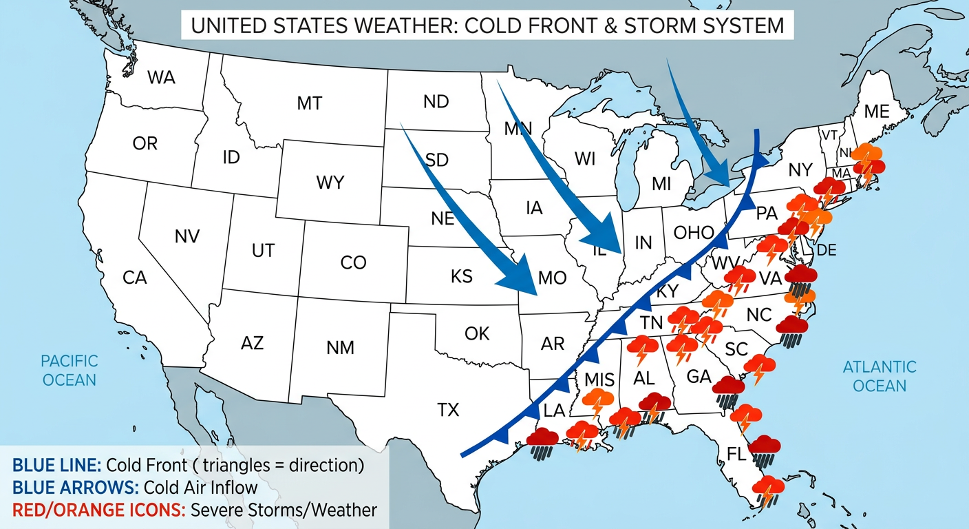
The Great Temperature Crash
Get this. Behind that front, the air is completely changing. We are talking about a 15 to 30 degree temperature drop for a lot of you in the eastern half of the country by the end of the week. You are going to swing from running the AC to digging out your hoodies in the blink of an eye.
It is the classic "false spring" whiplash we see this time of year.
Wind and Fire in the Plains
As that storm pulls away, it is dragging down some incredibly dry and windy air across the middle of the country. By Thursday, we have a Critical Fire Weather risk for the Texas and Oklahoma Panhandles, plus eastern New Mexico.
Places like Amarillo and Clovis are going to see humidity drop down to around 15 percent, combined with wind gusts of 25 to 35 mph. Please do not burn anything outdoors. A single spark could turn into a massive wildfire before you can even blink.
Up north, the National Weather Service in Bismarck is warning about wind gusts up to 70 mph in North Dakota. That is highway-closing, power-line-snapping kind of wind. Tie down your trash cans and lawn furniture today.
The Pacific Northwest is Still Getting Hammered
Let's not forget our friends out west. That atmospheric river is still pumping incredible amounts of moisture onshore.
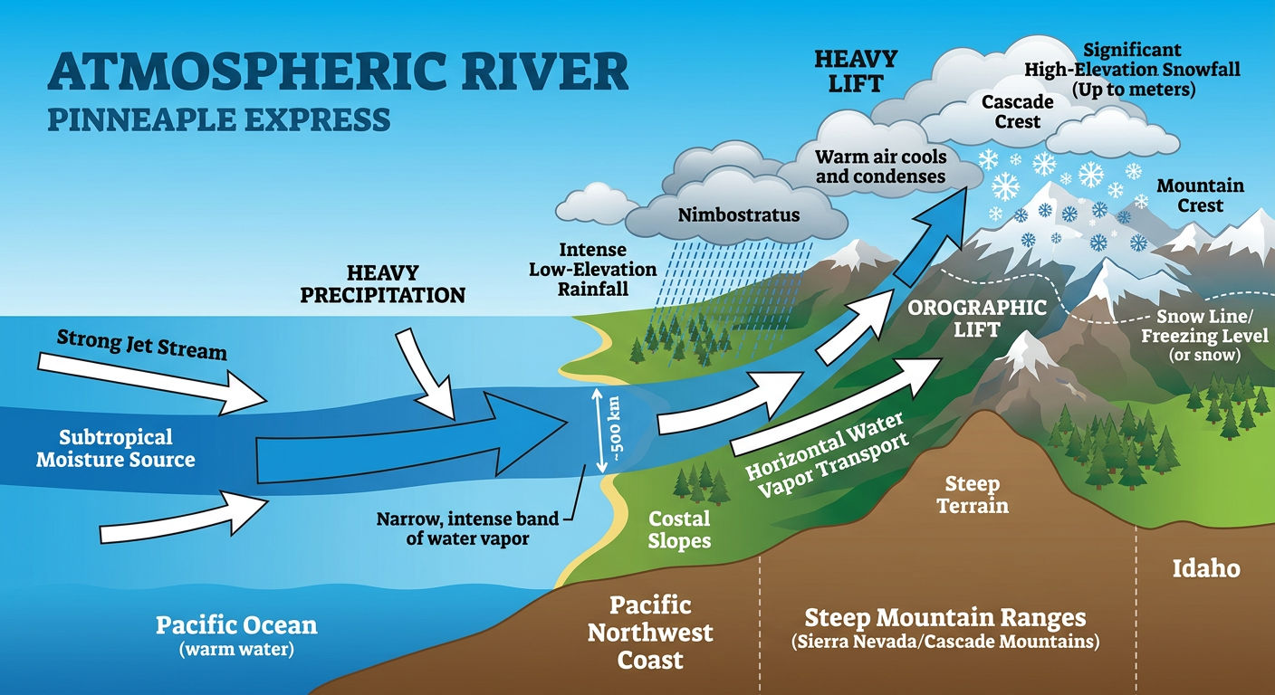
The Washington and Oregon Cascades are under an Enhanced Risk for winter impacts, with blizzard conditions continuing. We are talking feet of snow in the high elevations. If you were planning to drive through the passes, you really need to alter your plans. Down in the valleys around Seattle and Portland, it is just a whole lot of rain. If you are heading out to the Brujos Brewing anniversary event in Portland this weekend, bring the heavy rain gear.
Meanwhile, down in the Southwest, it is a completely different story. A massive ridge of high pressure is bringing record-breaking heat this weekend. If you are heading out to the Tasty Nights Street Food Festival in Mesa, Arizona, make sure you stay hydrated because it is going to feel a whole lot more like May than March.
The Bottom Line
- East Coast & Deep South: Watch out for severe storms and heavy, flooding rains today. Have a way to get warnings.
- Midwest & Ohio Valley: Brace for a 15 to 30 degree temperature drop as cold air rushes back in.
- High Plains (TX, OK, NM): Critical fire danger on Thursday. No outdoor burning.
- Pacific Northwest: Heavy coastal rain and dangerous mountain blizzards continue.
Stay weather aware out there, y'all. I will be back with another update as this wild March weather pattern keeps evolving.