Blog Article
US Weather Forecast: Ice in the East, Severe Storms in Texas
Tracking a messy winter mix and ice storm for the Mid-Atlantic and Appalachians, plus severe thunderstorms and hail targeting Texas and the Southern Plains.

From Ice Storms to Spring Storms: The Next Weather Whiplash
Alright folks, let's talk about what is coming down the pike. As we talked about over the weekend, that monster blizzard really did a number on the Northeast. We also saw an absolutely wild national temperature spread, with 103 degrees in Texas and wind chills of 70 below zero in Alaska.
Well, Mother Nature is not hitting the brakes anytime soon. We are trading that extreme temperature whiplash for a very messy, active weather pattern as we head into the first full week of March. We have a little bit of everything on the table. We are talking ice, severe storms, heavy rain, and even some critical fire danger.
Grab a coffee and let's break it down.
The Icy Setup For The Mid-Atlantic
Here is the thing about Tuesday. We have a lifting frontal boundary trying to push warm air across the eastern half of the country. But get this, the cold air does not want to leave.
We are looking at a classic "Cold Air Damming" setup. This is when sub-freezing air gets trapped east of the Appalachian mountains. Up above, a stout layer of warm air is going to ride right over that cold surface air. What does that mean for you? Freezing rain and sleet.
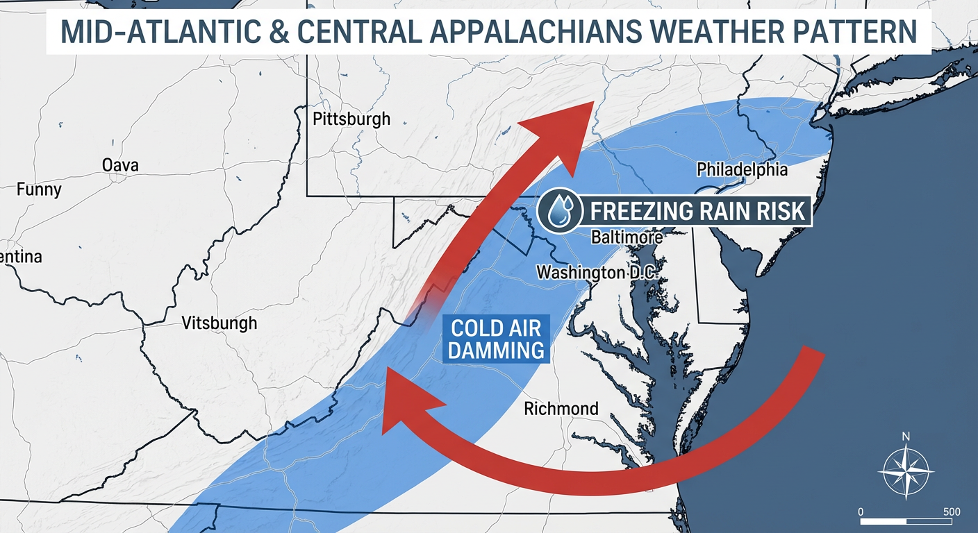
If you live in the higher elevations of West Virginia, western Maryland, or southwest Pennsylvania, you need to be prepared for a prolonged period of icing on Tuesday. The data is showing ice accumulations of 0.10 to 0.25 inches above 2500 feet. That is enough to make roads incredibly slick and maybe drag down a few tree branches.
I know "school closings and delays" is trending heavily on search right now. If you are in these areas, or even dealing with the wintry mix down towards Columbus, Ohio, you will definitely want to leave early for your commute Tuesday morning. And if you are planning on attending that ASC Fast outdoor training group in Arlington on Wednesday, keep an eye on the lingering cold and damp conditions.
Severe Storms Wake Up Down South
Now let's swing from winter coats back to AC and hoodies. As this mid-level disturbance ejects out west, it is going to pull a ton of Gulf moisture northward into the Plains.
Starting Tuesday evening, we have a Marginal Risk for severe weather from western Oklahoma into south-central and eastern Kansas. We are mostly looking at isolated thunderstorms capable of dropping large hail.
But Wednesday is the day we really need to watch.
The Storm Prediction Center has outlined a Slight Risk for severe storms across the Southern Plains and into the western Ozarks.
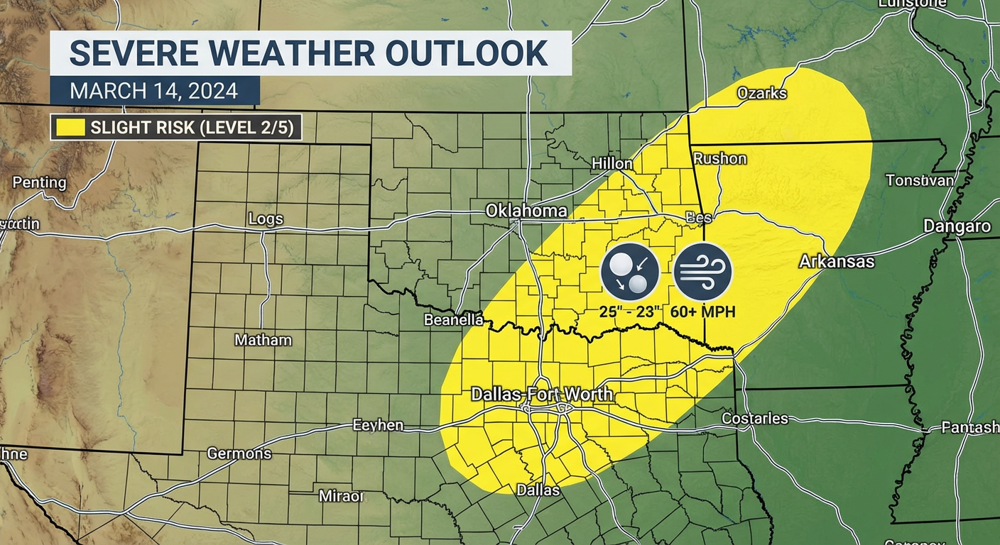
As a cold front advances southeastward, it is going to slam into a very warm, moist airmass. We are talking dewpoints in the 60s. If you live in Dallas, Fort Worth, Arlington, or up into western Arkansas, be on alert Wednesday afternoon and evening. Scattered thunderstorms are expected to fire up along that front. Large hail and damaging wind gusts are the primary threats here. Have a way to get warnings.
The Big Picture: What Else We Are Watching
- Critical Fire Weather: Out west, we have a completely different problem. Ahead of this storm system, dry downslope winds are going to kick up across the High Plains. Wind gusts up to 35 mph combined with humidity dropping below 15 percent will create near-critical fire weather conditions Tuesday. This includes eastern New Mexico, West Texas, and the Oklahoma/Texas Panhandles. Please do not burn anything outdoors.
- Heavy Ohio Valley Rain: That same stalled front causing ice in the mountains is going to act like a train track for heavy rain from the Midwest into the Ohio Valley. A Marginal Risk for excessive rainfall is in place Tuesday and Wednesday. We could see 1 to 2 inches of rain, and because the ground is dry in some of these spots, localized runoff issues are possible.
- More Snow for New England: Don't put the shovels away just yet. By Thursday and Friday, another round of moisture is going to interact with cold Canadian high pressure, bringing accumulating snow to northern New England. Maine and northern New Hampshire look to be in the bullseye for this one.
The Bottom Line
Y'all, this is a quintessential early March weather pattern. The seasons are fighting it out.
If you are in the Central Appalachians or Mid-Atlantic, prepare for a messy, icy Tuesday commute. Slow down on the bridges and overpasses. If you are in the Southern Plains, especially the DFW metroplex, make sure your weather radio has batteries and your phone notifications are turned on for Wednesday afternoon's severe storms. And out west, respect the red flag warnings and avoid any outdoor activities that could throw a spark.
Stay safe, keep an eye on the sky, and I will see y'all in the next update.
https://ryanhallyall.com/blog/from-ice-storms-to-spring-storms-the-next-weather-whiplash