Blog Article
Severe Storms Midwest & Heatwave Southwest | Weather Forecast
A massive temperature swing is bringing record heat to the Southwest and fueling severe storms in the Midwest and Ohio Valley this Thursday. Get the forecast.

From Record Heat to Severe Storms: The March Weather Rollercoaster Continues
Alright folks, welcome back. Yesterday we talked about the absolute madness happening in our atmosphere, from severe storms in Pennsylvania to those critical wildfires in Texas. Well, here is the thing. The weather rollercoaster is not stopping anytime soon. In fact, we are about to climb another huge hill before taking a steep drop later this week.
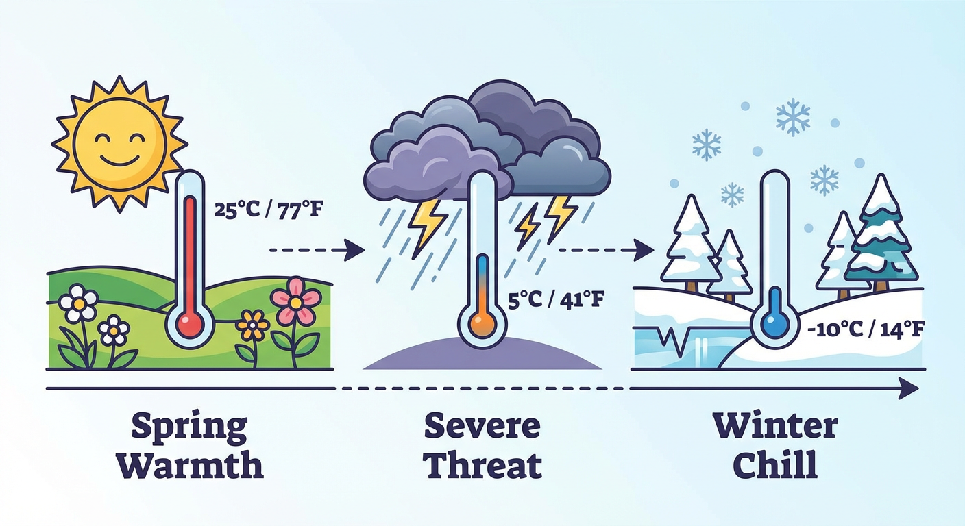
We are looking at a classic spring transition setup. We have a massive thermal shift happening right now. Record heat is building in the West, and that energy is going to march eastward, eventually colliding with a strong cold front. That collision is going to spark our next big severe weather threat.
Let's break down exactly what you need to know and how this might impact your week.
The Heat is On in the Southwest
First up, let's talk about this heat. If you are in the Desert Southwest, you probably already know what I am talking about. We are looking at temperatures running 25 to 35 degrees above average for this time of year.
Phoenix is forecast to hit 96 degrees tomorrow. If you are heading out to the Mariners vs. White Sox or the D-backs vs. Padres games today in Arizona, you absolutely need to stay hydrated and keep the AC running. This is serious, record-breaking heat for March. We already saw Phoenix hit 105 degrees a few days ago, and this persistent heatwave is keeping the ground baked and the fire danger high across the Plains.
Thursday's Severe Weather Setup
Now, all that warm, moist air is going to get pulled north into the central United States. At the same time, we have a dynamic cold front sweeping down from the northwest. When these two air masses meet, they are not going to play nice.
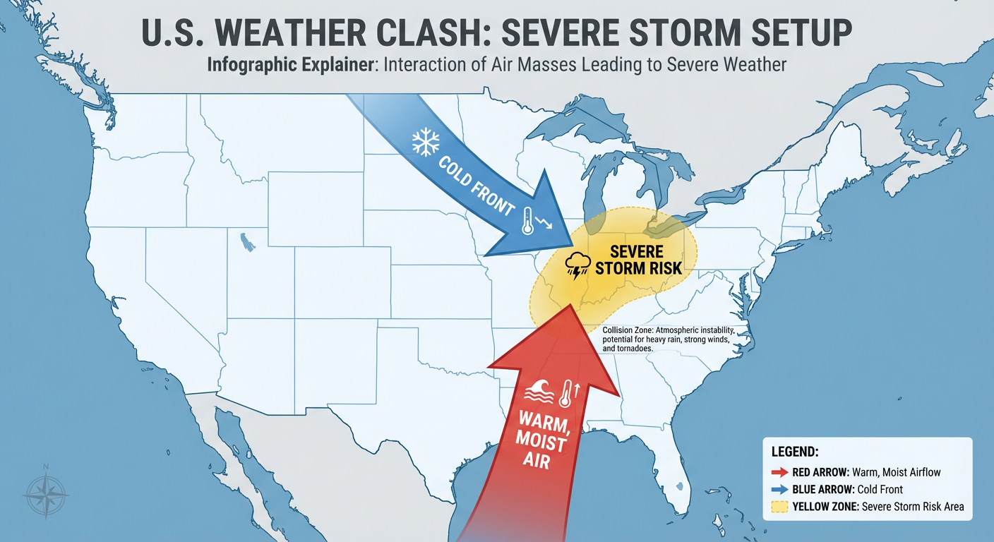
The Storm Prediction Center has already highlighted a 15% risk area for severe thunderstorms on Thursday covering over 112,000 square miles. That includes nearly 20 million people.
Here are the key areas we are watching for Thursday afternoon and evening:
- St. Louis, Missouri: You will likely see the storms initiate as the front arrives.
- Indianapolis, Indiana: Have a way to get warnings Thursday evening.
- Columbus and Cleveland, Ohio: The severe threat will push into your area as we head into Thursday night.
- Toledo, Ohio: You are right on the northern edge of this risk zone.
We are expecting scattered to numerous thunderstorms to develop along this advancing cold front. The main threats right now look to be damaging straight-line winds and large hail, but as we always say, you cannot rule out an isolated tornado when a system is this dynamic. If you live in the Ohio River Valley, Thursday is your alert day.
Winter's Last Gasp?
Get this. Once that severe weather pushes through, the bottom is going to fall out of the thermometer. We are going to go from severe thunderstorms right back to winter coats in a matter of hours.
The Climate Prediction Center and the Weather Prediction Center are tracking a progressive flow pattern that will drag some very cold air into the Ohio Valley and Northeast late this week and into the weekend.
There is currently a 15% probability for impactful wintry precipitation for places like Portland, Maine, and Burlington, Vermont by the weekend. If you are in the Northeast, or even the upper Ohio Valley, do not pack away your heavy jackets just yet. You will be swinging from AC to hoodies, and eventually back to winter gear before the week is done.
The Bottom Line
Here is what you actually need to do this week:
- In the Southwest: Treat this like mid-summer heat. Limit outdoor activities during the peak afternoon hours and check on your neighbors.
- In the Midwest and Ohio Valley: Start preparing now for Thursday. Make sure your weather radio has batteries and your phone alerts are turned on. If you commute through Indianapolis or Columbus, plan for a messy Thursday evening drive.
- In the Northeast: Enjoy any mild days you get early this week, but be ready for a messy, potentially wintry transition heading into the weekend.
We will keep an incredibly close eye on Thursday's severe threat as the high-resolution models get a better look at it. Stay weather aware, y'all!