Blog Article
Gulf Coast Flooding Continues & Plains Severe Weather Setup
Tropical Storm Arthur's remnants bring continued flood risks to the Gulf Coast today, while the Central Plains brace for severe storms and large hail Saturday.

Gulf Coast Floods Shift East, Plus a Nasty Saturday Setup for the Plains
As we talked about yesterday, the situation down south has been heartbreaking. The Anchor Lake Dam failure and those flash flood emergencies in Louisiana and Mississippi are still very much active situations. Today, the remnants of Tropical Storm Arthur are slowly sliding east.
The Weather Prediction Center has a Moderate Risk for excessive rainfall over the central Gulf Coast today. That stretches from central Mississippi across the Florida Panhandle and into southwest Georgia. If you live in those areas, keep your guard up. The ground simply cannot take another drop of water, and any new rain is going to run right off into the streets and creeks.
A Serious Saturday in the Plains
Alright folks, we need to talk about tomorrow. The Storm Prediction Center has outlined an Enhanced Risk for severe weather across the Central Plains, specifically targeting eastern Colorado and Kansas. This is not a forecast to ignore.
We are looking at a classic late-June setup. Denver normally tops out around 83 degrees this time of year, and Kansas City averages 84. We are going to see plenty of heat and moisture pooling ahead of a system ejecting out of the Rockies. The main threats are going to be massive hail and damaging winds.
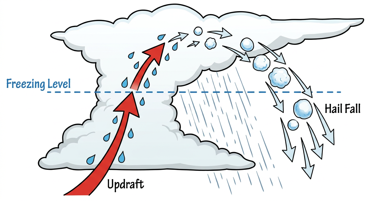
The SPC has a 30 percent hatched area for both wind and hail. That hatched area is important. It means we could see hailstones two inches or larger, which is hen-egg size, and wind gusts over 75 mph. There is also a 5 percent hatched risk for tornadoes, meaning an EF2 or stronger tornado is possible if the ingredients line up just right.
Flash Flooding Follows the Storms
It is not just the wind and hail we have to worry about. The WPC also has a Moderate Risk for excessive rainfall posted for the Central Plains and Missouri Valley on Saturday.
These individual supercells are going to grow into a large complex of storms as the sun goes down. They will likely dump heavy rain over southeastern Nebraska and surrounding areas. If you are traveling on I-80 or I-70 this weekend, leave early or plan your route around these storms. You do not want to be driving a high-profile vehicle through 75 mph crosswinds and blinding rain.
Critical Fire Weather Out West
While the middle of the country deals with storms, the West has a completely different problem. We have a Critical Fire Weather area today for northern California, extreme southern Oregon, and northwestern Nevada.
Dry thunderstorms and gusty winds out of the southwest are a bad combination for wildfire starts. I know folks are heading to Reno for the BBQ, Brews and Blues Festival this weekend. The festival itself should be fine, but if you are driving through those critical fire areas, please be extra careful with anything that could spark a flame.
Key Factors We Are Watching
- Arthur's leftovers: The exact track of the tropical moisture across the Florida Panhandle today.
- Storm initiation: The timing of when storms first fire up in eastern Colorado on Saturday afternoon.
- The transition: Watching how quickly discrete supercells merge into a bowing line of storms in the Plains tomorrow night.
Bottom Line
If you are on the Gulf Coast, respect the barricades and stay out of floodwaters today. If you live in Kansas, Colorado, or Nebraska, use today to secure loose items in your yard and make sure your weather radio has fresh batteries. Have a reliable way to get warnings that will wake you up tomorrow night.