Blog Article
Southwest Atmospheric River Brings Flood Risk This Weekend
A potent atmospheric river threatens Moderate-Risk flash flooding across Arizona, Utah, and the Four Corners this weekend, while severe storms build over the southern Plains by Monday.
Halloween Night Looks Quiet, But a Southwest Atmospheric River Is About to Get Serious
Alright y'all, happy Halloween. Before we get to candy and costumes, let's talk about the weather story that actually matters this weekend, and it's not out East. It's the Desert Southwest, and it's about to get wet in a hurry.
The Big Story: Atmospheric River Taking Aim at the Four Corners
Here's the thing. We already got a preview of this last night. Central Arizona and southern Nevada took a beating from slow-moving thunderstorms. Sonoran Wash north of Phoenix went from dry to 6 feet deep, blowing well past its 3.5-foot bankfull stage, and fire crews had to pull people out of floodwaters near Scottsdale and Paradise Valley. Las Vegas picked up ping-pong-ball hail and flash flooding that closed roads near Lake Las Vegas Parkway. That was just the opening act.
WPC has a Slight Risk of excessive rainfall up today across central Arizona, but the real event is tonight into Sunday. A subtropical disturbance is digging a plume of deep moisture straight into the Southwest, and by Sunday WPC has bumped the Four Corners region, including the San Juan Mountains of southwest Colorado and portions of southern Utah, up to a Moderate Risk of excessive rainfall. That's not a label WPC hands out lightly.
What makes this one dangerous is the sheer amount of moisture involved. Precipitable water values, basically a measure of how much rain the atmosphere has loaded up and ready to wring out, could run 3 to 6 standard deviations above normal for this time of year. Translate that to real numbers and you're looking at widespread totals of 2 to 4 inches across favored terrain, with locally higher amounts possible in the Mogollon Rim, the Sonoran washes, and the steep terrain around the San Juans.
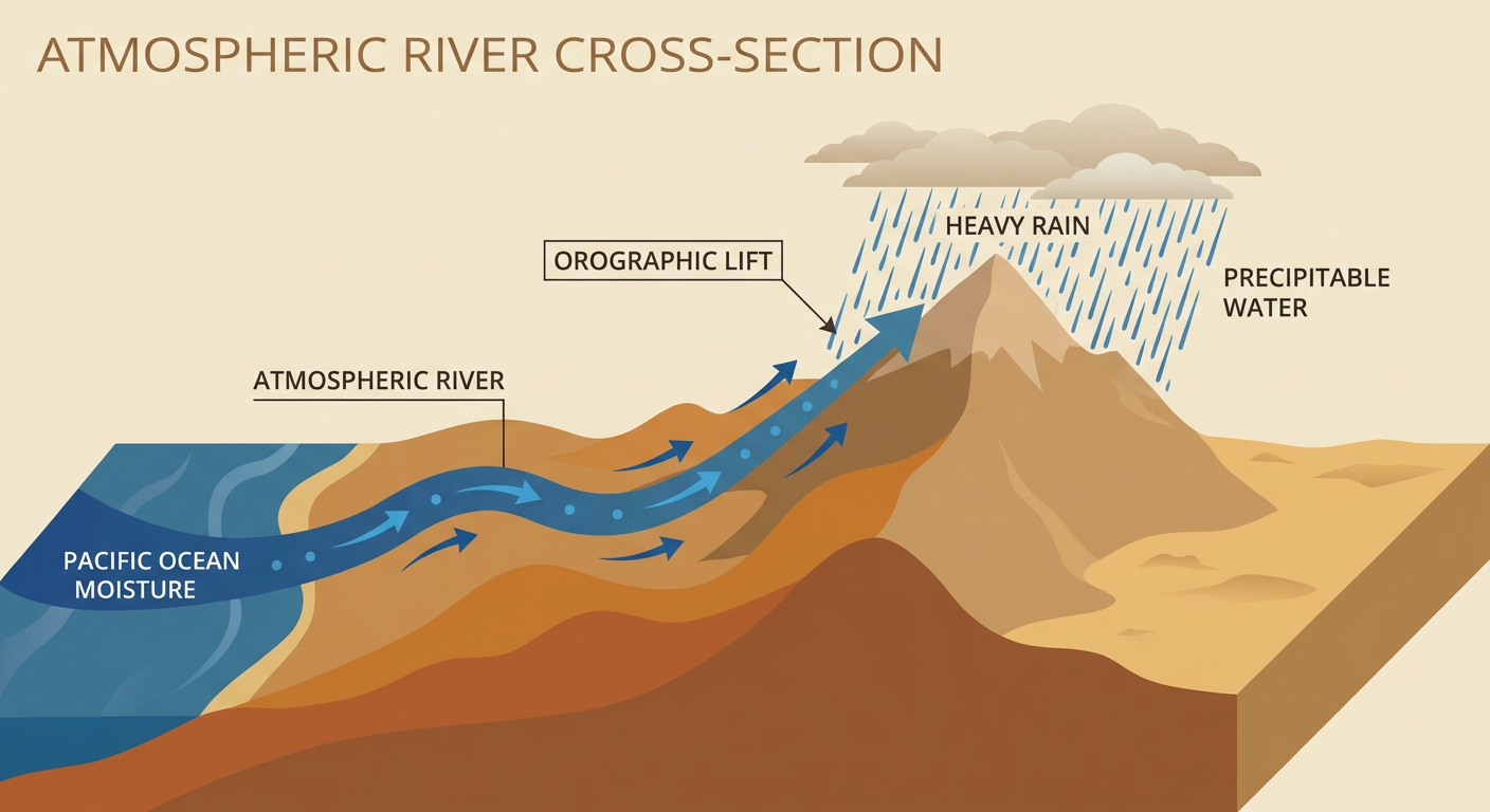
This matters because the ground in a lot of these spots is already saturated from last night, and some of this terrain includes burn scars where even modest rain runs off fast and hard. If you're anywhere near Phoenix, Flagstaff, the Mogollon Rim, southern Utah along the I-15 and I-70 corridors, or the San Juan basin in Colorado, Sunday is the day to pay attention to local flash flood warnings, not just the forecast.
Timeline:
- Tonight (Halloween): Rain increases across central Arizona, mainly after dark
- Sunday: Atmospheric river peaks, Moderate Risk of excessive rainfall across the Four Corners
- Monday: Rain tapers but lingering Slight Risk shifts toward the East Coast of Florida as a tropical wave finishes its crossing
Severe Weather Watch: Southern Plains by Monday
While the Southwest deals with flooding rain, a separate system is setting up trouble for the southern and central Plains. SPC has a Marginal Risk of severe storms posted today into Sunday for central New Mexico into the Texas Panhandle, including Albuquerque and Amarillo, as a disturbance moves out of Baja California. Isolated damaging gusts are the main concern there, nothing widespread.
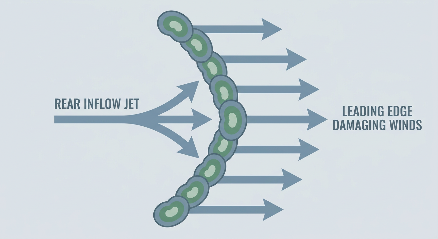
The bigger watch is Monday. SPC has upgraded parts of western and central Oklahoma into southeast Kansas to a Slight Risk, which covers Oklahoma City, Tulsa, Wichita, and Topeka. A Marginal Risk extends south into Dallas-Fort Worth and Kansas City. The setup: a large upper trough crosses the Rockies and drops into the Plains Monday, with a leading wave sparking scattered storms by late afternoon. Damaging wind gusts are the headline threat, and it's worth having a way to get warnings Monday afternoon and evening if you're in that corridor.
What About Trick-or-Treat Tonight?
Good news here. Today's nationwide weather discussion shows the main theme is clouds, not storms, for most of the country. If you're headed to the Texas Renaissance Festival's Hallowe'en event in Todd Mission, the Ye concert in Houston, or Wings Over Houston, none of those spots are under a severe threat today. The marginal severe risk stays well to the west over New Mexico and the Panhandle. Expect a mild, cloudy evening across most of Texas with no weather reason to cancel plans.
Further north, folks at Jurassic Quest in Cleveland or Green Bay, or anyone at the Breeders' Cup grounds in Lexington, should see a quiet, cloudy Halloween with no major disruptions. The best actual weather in the country today sits over central and western New York and far northeastern Pennsylvania, where skies clear out nicely behind departing lake-effect clouds.
A Quick Sky Note: Minor Geomagnetic Storm Tonight
NOAA's Space Weather Prediction Center has a G1 (Minor) geomagnetic storm watch up for tonight into Saturday, driven by a coronal hole high-speed stream. Kp could reach 5. That's not a big event, but if you're way up in the northern tier, Alaska, or far northern Canada under clear skies, keep an eye to the north after dark. It's a nice little bonus on a night when everybody's already looking up anyway.
Key Factors We're Watching
- Atmospheric river intensity Sunday across central Arizona, the Mogollon Rim, southern Utah, and the San Juan Mountains, where WPC has a Moderate excessive rainfall risk
- Saturated ground and burn scars from Thursday and Friday's rain, which lowers the bar for new flash flooding
- Monday's Slight Risk severe setup over Oklahoma, southeast Kansas, and the southern Plains, with damaging wind gusts the top concern
- A Pacific tropical disturbance (CP-AREA-1) well southeast of Hawaii, currently just a 40% chance of development by day 7 and no threat to the mainland
- Coastal tidal flooding continuing to ease along the Southeast Atlantic and Southern California after a very active King Tide stretch this month
Bottom Line
If you're in the Desert Southwest, especially central Arizona, southern Utah, or southwest Colorado, Sunday is your day to have a plan for flash flooding. Avoid washes, don't drive through flooded roads, and check local alerts before heading into canyon country or burn scar terrain. If you're in Oklahoma or the southern Plains, keep Monday afternoon on your radar for isolated damaging wind gusts. Everybody else, especially trick-or-treaters tonight, you're in good shape. Enjoy the evening.