Blog Article
Norbert's Remnants Threaten a Hawaii Still Drying Out
A weakened Norbert nears Hawaii Island as the state recovers from Lowell, while Kansas City faces a moderate flood risk and Arizona's monsoon flares up next.
Hawaii's Weary September: What's Left of Norbert Means for an Island Already Drying Out
Y'all saw that Kauai story trending tonight. A man fighting for hours as a river swept his own house away. That's not some old headline resurfacing for no reason. It's a gut-punch reminder of what Hurricane Lowell did to that island barely a week ago, when it tracked past as a Category 2 to 3 storm with gusts to 85 mph and enough surge to chew up homes at Baby Beach in Poipu. Kauai is still cleaning up. And this week, the sky isn't giving the islands much of a breather.
What's Left of Norbert
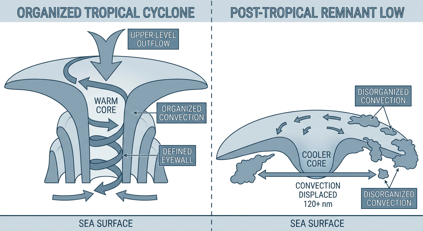
Here's the thing about Norbert. It's not a hurricane anymore. NHC dropped its last advisory this morning, and the language in that discussion is worth understanding: forecasters said Norbert "has lacked organized deep convection for about 18 hours now," with the only remaining thunderstorm activity more than 120 nautical miles from the center. That's the technical definition of post-tropical. No more warm-core engine, no more classic hurricane structure. Just a spinning remnant low pushing west at 13 mph with max winds around 35 mph.
But "post-tropical" doesn't mean "harmless." It means the wind threat has mostly faded while the moisture threat can still linger. Our impact model has Norbert passing within roughly 30 miles of Hawaii Island's east side, including Hilo, sometime around Wednesday. The threat level there is rated "aware," which is the lowest tier we track, not a warning-level call. Still, this arrives on ground that's already saturated from Lowell and from earlier systems this month. Even a modest plume of tropical moisture on top of soaked soil is worth watching, especially for anyone near streams on the Big Island's east flank.
Down the ocean a ways, Tropical Depression Fifteen-E is doing the opposite. It's weakening fast, over a thousand miles southwest of Baja, and it's got no coastal watches and no path toward land. That one's just fading out quietly. And out in the Atlantic, there's a trough east-southeast of Bermuda that NHC gives a 40 percent shot at organizing into a depression by the end of the week. Nothing threatening the US coast yet, just something to keep half an eye on as we roll deeper into peak season.
Meanwhile, Kansas City Is Getting Soaked Tonight
Back on the mainland, the bigger flood story tonight isn't a coastline, it's the Kansas-Missouri state line. WPC has a Moderate Risk of excessive rainfall over northeastern Kansas into northwest Missouri through Wednesday morning, and that includes the Kansas City metro and Topeka. The forecast office language is blunt: this is a training-storm setup, meaning cell after cell rides over the same corridor, with 3 to 5 inch totals possible on top of ground that's already primed from recent rain. If you're anywhere near Kansas City tonight and you see water starting to rise on a low road, don't play chicken with it. Turn around.
This comes on the heels of a rough stretch for the Plains. Just two days ago, an 84 mph thunderstorm wind gust knocked out power around Chanute, Kansas, part of a run of severe weather that's hit the region multiple times this month. The ground out there has taken a beating, and tonight's rain is landing on soil that hasn't fully recovered.
Arizona's Turn Comes Wednesday
Once the Kansas City threat clears out Wednesday morning, the excessive rainfall risk jumps clean across the country to southern and central Arizona, where WPC has now raised a Moderate Risk for Day 2. This is the same monsoon pattern that's been hammering the Southwest all month, and the forecast discussion flags rainfall rates near 2 to 2.5 inches per hour with 2 to 3 inch storm totals possible around the Mogollon Rim. Tucson and Phoenix forecasters are watching burn scars, washes, and slot canyons closely, because that terrain floods fast and gives you almost no warning. If you're anywhere near Sedona, the Rim country, or a dry wash in that part of the state Wednesday afternoon, keep the forecast pulled up.
A Little Something for the Night Game Crowd
One more item, low-stakes but fun. NOAA's space weather forecasters are calling for G1, or Minor, geomagnetic storm levels tonight and tomorrow, with a peak around Kp 5 driven by a combination of a coronal hole stream and some flanking effects from CMEs that left the sun a couple days ago. G1 is the mildest tier on the geomagnetic storm scale. It's not going to paint the sky green over most of the country. But if you're way up in the northern tier tonight, maybe catching that Yankees-Twins game up in Minneapolis, it's worth a glance north between innings. No promises, but the ingredients are there for the far northern latitudes to get a faint show.
The Takeaway
Hawaii's September has been long. Lowell left real damage behind, and now a weakened, post-tropical Norbert is sliding past with just enough moisture to matter on already-soaked ground. Meanwhile the mainland flood risk is doing its own relay race this week, handing off from Kansas City tonight to Arizona's burn scars by Wednesday. None of it is a single big headline. It's a string of smaller, connected stories, and that's usually how a busy September actually plays out.