Blog Article
Storms Shift North, Heat Wave Builds: June 27 Forecast
An Enhanced Risk for severe storms hits eastern Montana and North Dakota today while a dangerous heat wave starts building across the central and eastern U.S.

Heat Builds, Storms Shift North: What Changes After June's Wild Run
Alright y'all, let's talk about where things stand. June 2026 has been one long, loud month. Flash flood emergencies in Wichita and Atoka County. A measured 110 mph gust near Slaton, Texas. A 113 mph reading back in Salina on the 8th. Last night kept the streak alive, with an 86 mph gust at the Stillwater airport that flipped a small plane and damaged eight others, plus curb-deep flooding through Payne County, Oklahoma.
Here's the thing though. The pattern's finally shifting, and the next few days look different from the rhythm we've been stuck in.
Today's Severe Threat Lives Up North
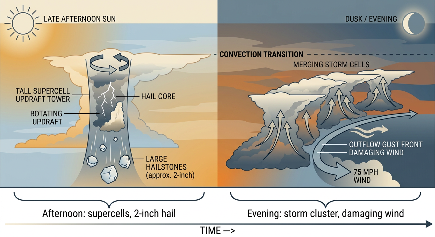
The Storm Prediction Center has the highest risk way up on the northern High Plains again today. An Enhanced Risk, level 3 out of 5, covers eastern Montana into western North Dakota. We're talking Baker, Glendive, Sidney, and the country around Plentywood.
What the data shows for that zone:
- A 30% wind probability, with a hatched area for gusts of 75 mph or higher
- A 30% hail probability, with a hatched area for hail 2 inches or larger, that's hen-egg size
- A 5% tornado probability, level 2 of 5, meaning a few tornadoes are possible
The SPC discussion lays out the recipe plainly. A lee cyclone deepens through the afternoon, supercells fire near the Montana and North Dakota border, then those storms cluster into a complex by evening that throws out a swath of damaging wind. Very large hail is the headline early, damaging wind takes over late.
A Slight Risk wraps around that core through western South Dakota and Nebraska. There's also a separate Slight Risk pocket back east across North Carolina, including Charlotte and Raleigh, where yesterday already brought a string of trees-down reports near Siler City and Steeds. A broad Marginal Risk stretches across the mid-South and Ohio Valley, from Nashville and Louisville up through Kansas City.
If you're in eastern Montana or the western Dakotas, today's the day to keep a way to get warnings close by. The Twins host the Rockies in Minneapolis tonight and that's outside the risk zone, but the broader northern Plains setup is worth watching if you've got outdoor plans up that way.
The Flood Threat Eases, But It's Not Gone
For most of June, the bigger story has been water, not wind. The good news this morning: the Weather Prediction Center has backed the excessive rainfall threat down to a Slight Risk today, running from the mid-Mississippi Valley into the southern Appalachians, plus a piece up on the northern Plains.
That's a step down from the high-end situations we saw earlier this week. Local forecasters in Tulsa, Springfield, and Wichita are still flagging saturated ground from the recent rains, so it doesn't take much to get water back over roads in the usual low spots. But the catastrophic, city-flooding setup that hit Wichita on the 26th is not on the table today.
By Sunday and Monday the excessive rainfall risk drops to Marginal and shifts toward northwest Montana and the Great Lakes. That Montana rain comes with an interesting twist: an upper low parks over the region, and snow is possible above about 6,500 feet near Glacier. Late-June mountain snow. It happens.
Heat Is the Story for the New Week
Here's what's actually changing. A big upper ridge is building over the eastern two-thirds of the country, and it's going to pump heat and humidity northward through the new week.
Forecasters are already talking about a dangerous heat wave expanding into the Plains and the Mississippi and Missouri Valleys. The pattern discussions describe oppressive overnight lows, the kind that don't let your house or your body cool off between days. That's the part of a heat wave that does the real damage.
For context, late June normals run hot already. Kansas City sits near a 84-degree average high, St. Louis around 85, Nashville and Oklahoma City near 88. When a heat ridge stacks on top of normals that are already in the upper 80s, you get into territory where the heat becomes a genuine health concern, especially for folks without good AC and for anybody working or playing outside.
If you've got plans this week, the central and eastern U.S. is where the heat builds. The best comfortable weather sits out West, in the California valleys and the Intermountain West, where drier air keeps things more reasonable.
Fire Weather Holds in the Four Corners
One more piece out West. The SPC has an Extremely Critical fire weather area today for parts of western Colorado and eastern Utah into the Four Corners, with a broader Critical area across southern Nevada, southern and central Utah, western Colorado, northeastern New Mexico, northern Arizona, and south-central Wyoming.
That's the same regime that drove the Cottonwood Fire near Beaver, Utah, up to about 72,000 acres earlier this week. Strong wind plus single-digit-to-teens humidity plus dry fuels. Any fire that starts can spread fast. This continues into Sunday for the Four Corners.
What I'm Watching
- Eastern Montana and western North Dakota for supercells this afternoon turning into a wind-producing complex tonight. Very large hail early, damaging gusts late.
- Saturated ground across the mid-Mississippi Valley and Ozarks, where even a Slight rainfall risk can flood the usual low spots.
- The building heat ridge across the central and eastern U.S., with the real concern being oppressive overnight lows by midweek.
- Four Corners fire weather, dangerous and ongoing through Sunday.
Bottom Line
If you're on the northern High Plains today, treat it like a have-your-plan-ready afternoon: know how you'll get warnings, and don't sit out a hailstorm in eastern Montana or the western Dakotas. Everybody in the mid-South and Ohio Valley, the storm risk is lower but not zero, so keep half an eye on the sky if you're outside. And across the central and eastern states, start thinking now about the heat. Check your AC, plan to hydrate, and look in on older neighbors as this ridge builds through the week. Out West in the Four Corners, one spark is all it takes today.
https://ryanhallyall.com/blog/heat-builds-storms-shift-north-what-changes-after-junes-wild-run