Blog Article
Severe Weather Threat: Large Hail in Oklahoma and Texas
A Level 2 Slight Risk for severe storms targets Oklahoma and North Texas today. Expect large hail, damaging winds, and heavy Gulf Coast rain.

Hen-Egg Hail Threatens the Southern Plains Today
Alright y'all. Yesterday we talked about that warm front lifting into East Texas and crashing the Red Dirt BBQ Festival. Today, we need to shift our focus just a bit to the west and north. We have a classic spring setup taking shape across the Southern Plains, and it is going to bring a few different hazards to the table.
Here is the thing. A subtle shortwave trough is moving through the central US today. That is just a meteorology term for a pocket of cold air and energy in the upper atmosphere. When that energy meets the warm, juicy air pooling over Oklahoma and North Texas, storms are going to fire.
The Severe Threat for Oklahoma and Texas
The Storm Prediction Center has a Slight Risk posted for today. That is a Level 2 out of 5. The risk area stretches from southeast Kansas down through central and eastern Oklahoma into North Texas. This includes Oklahoma City, Tulsa, Norman, and Wichita Falls.
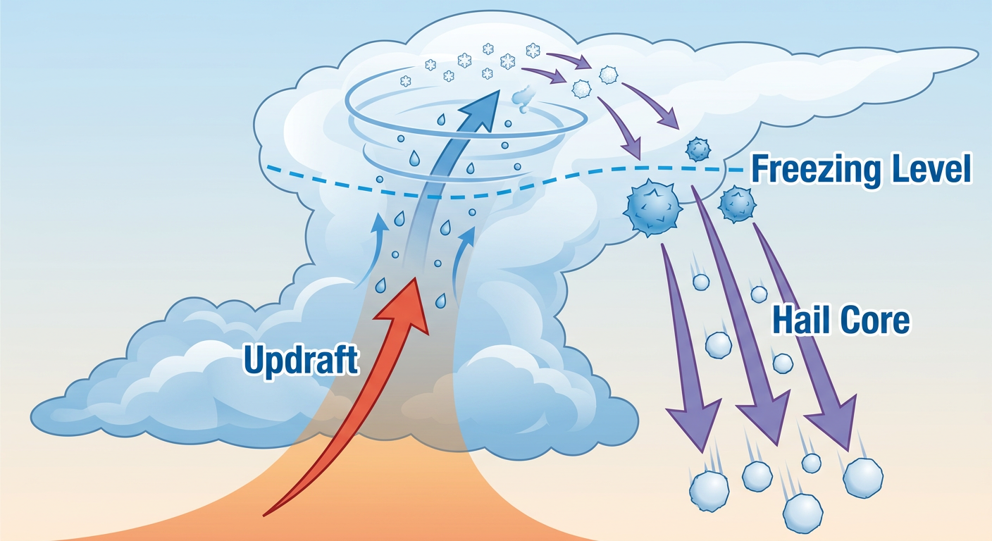
The main concern today is large hail. We are looking at a 15 percent chance of severe hail within 25 miles of any point in that area. Get this. There is a specific hatched area inside that risk zone where hailstones could reach two inches in diameter. That is hen-egg size, folks. If you park outside in Norman or Lawton, you might want to clean out the garage this afternoon.
We also have a 15 percent chance for damaging wind gusts over 60 mph. An isolated tornado is not out of the question either, with a 2 percent probability across the region. It is a day to pay attention to the sky.
This active pattern does not stop tonight. Tomorrow, the severe threat shifts slightly westward. We have another Level 2 Slight Risk for western Oklahoma and northwest Texas for Saturday. High-based supercells are expected to develop near a boundary triple point tomorrow afternoon, bringing another round of large hail and gusty winds.
Gulf Coast Soakers
Down on the Gulf Coast, that same moisture pool is causing a different kind of headache. The Weather Prediction Center has a Slight Risk for excessive rainfall over southeastern Louisiana and southern Mississippi today.
The atmosphere down there is holding over two inches of precipitable water. That means any storm that forms is going to dump rain like a bucket. If you are driving I-10 near New Orleans or up I-55 toward Jackson, watch out for water ponding on the roads. Localized flash flooding is a real threat in poor drainage areas, especially considering the heavy rain some of these spots saw earlier this week.
Building Heat Out West
Out West, the story is completely different. We are watching a major warming trend build into the Desert Southwest and Central California.
The San Joaquin Valley is looking at a high probability of triple-digit heat by early next week. Normal May highs for a place like Los Angeles sit around 74 degrees, but the interior valleys are going to be baking well above normal. The local National Weather Service office in Hanford is already warning about Major HeatRisk levels. If you live in those areas, start preparing your cooling plans now.
The Bottom Line
If you live in Oklahoma or North Texas, have a plan for your vehicles this afternoon. Make sure your weather radio has batteries, and keep your phone charged. If a severe thunderstorm warning is issued for your town, move away from windows and get to an interior room. For folks on the Gulf Coast, remember to never drive through flooded roadways.
https://ryanhallyall.com/blog/hen-egg-hail-threatens-the-southern-plains-today