Blog Article
High Plains Severe Storms Target Denver and Cheyenne Again
An Enhanced Risk for severe storms hits the central High Plains today with large hail and 75+ mph winds near Denver and Cheyenne, plus Mid-Atlantic and flood threats.

High Plains Gets Round Two: Severe Storms Aim for Denver, Cheyenne, and the I-76 Corridor Again
Alright y'all, if you live out on the Colorado and Wyoming high country, yesterday was no joke. We had measured wind gusts of 113 and 109 mph near Akron, Colorado. Grapefruit-sized hail, four inches across, fell near Joes. Six inches of hail piled up on roads in Logan County, the kind of thing you need a snowplow to clear in late June. And here's the part nobody wants to hear: the atmosphere is setting up to do it again today.
The Storm Prediction Center has an Enhanced Risk, that's a Level 3 of 5, posted across the central High Plains. That box covers Denver, Cheyenne, Akron, Burlington, and Cheyenne Wells. About 3.1 million folks live inside it. Around that core, a Slight Risk stretches down through Oklahoma City, Colorado Springs, Tulsa, and Wichita, with a Marginal Risk reaching all the way out to Dallas, Kansas City, Omaha, and Raleigh.
Why The High Plains Keeps Firing
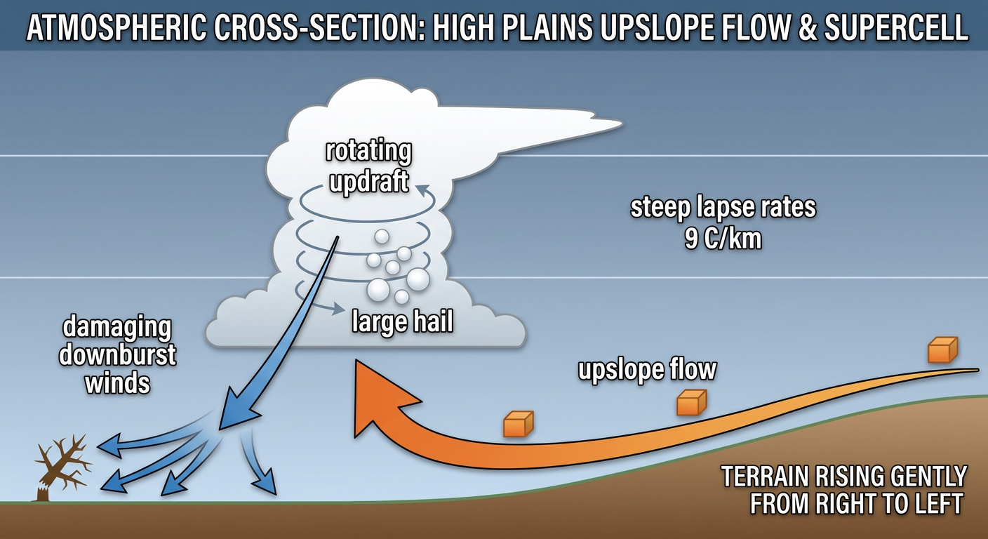
Here's the thing about this setup. You've got hot, dry westerly flow aloft riding over a heating ground, and when that air gets shoved up against the higher terrain of the Front Range, it's called upslope flow. Moisture pools at the surface, the air rises, and storms blow up fast in the afternoon.
The ingredients today are loaded. The local forecast offices are talking about lapse rates around 9 degrees Celsius per kilometer, which is meteorologist-speak for a really steep drop in temperature as you go up. Steep lapse rates mean strong updrafts. Strong updrafts mean big hail. Add in close to 50 knots of effective bulk shear, which is the change in wind with height that lets storms rotate and stay organized, and you've got a recipe for supercells.
What does that mean if you're under it? SPC is spelling it out: hail two inches and bigger, that's hen-egg size, wind gusts of 75 mph or more, and isolated tornadoes are on the table. Inside the hatched zones, the hail and wind could run even higher. We saw exactly that yesterday.
Denver normally runs about 83 for a high this time of year. The Rockies are in town tonight hosting the Red Sox, first pitch around 6:40 local. If you're headed to Coors Field, keep one eye on the sky in the late afternoon and early evening, because that's when these storms tend to fire and roll east off the foothills.
The Mid-Atlantic Stays In The Game
The Mid-Atlantic isn't done either. There's a Slight Risk posted there, and yesterday that region took a beating. We logged dozens of tree-down reports from Virginia up through Pennsylvania, with a confirmed tornado near Fairmont, West Virginia, and another up around Savageton, Wyoming earlier in the day. Today the main threats from Delmarva into eastern North Carolina are damaging wind gusts and a brief tornado or two along a sharpening boundary.
That's worth flagging if you've got plans. The Phillies are at the Nationals in DC tonight, and the Cubs are at the Mets in Queens. Washington normally sits near 85 for a high in late June, plenty warm and muggy, and pop-up storms could shuffle those evening schedules.
Don't Sleep On The Rain
The Weather Prediction Center has a Slight Risk of excessive rainfall over the central and southern Plains down into the Lower Mississippi Valley. A quasi-stationary front is parked across the ArkLaTex and Red River basin, and storms keep training over the same ground. Here's why that matters more than usual: the soils down there are already soaked. We watched 2 to 3 inch per hour rates trigger flash flooding and water rescues around Memphis and Lexington just yesterday. When the ground can't soak up any more, even a couple inches turns roads into creeks fast.
The DFW metro is on the edge of that rain threat. Dallas normally hits 92 this time of year, so it'll still be hot and sticky between the downpours.
What I'm Watching
- Afternoon initiation on the Front Range. Storms should fire between mid and late afternoon near the higher terrain and march east toward the I-76 corridor. That's the same path that got hammered yesterday.
- The overnight MCS threat. If those High Plains storms congeal into a mesoscale convective system after dark, you can get a long swath of 75-plus mph winds. We've seen this pattern repeat all month.
- Flash flooding on saturated ground across the ArkLaTex and into the Lower Mississippi Valley. It doesn't take much rain on soil that's already full.
- The Mid-Atlantic wind and tornado threat from the Delmarva into eastern North Carolina through the evening.
One thing worth noting: tomorrow the focus shifts a bit, with a Slight Risk dropping down over the central and southern High Plains again, including Denver, Amarillo, and Pueblo. This pattern isn't breaking yet.
Bottom Line
If you're in eastern Colorado, southeast Wyoming, or anywhere in that Enhanced Risk box, today is a have-your-plan-ready kind of day. Know where you'll shelter from large hail, keep your phone charged and alerts turned on, and don't get caught driving through a storm with hail that big. For the Mid-Atlantic, watch for fast-moving evening storms with damaging gusts. And across the soaked Southern Plains, turn around if you hit a flooded road. We've already had too many water rescues this month. Check back tomorrow morning and we'll see where this restless pattern points next.