Blog Article
Hurricane Simon: Cat 4 Storm Threatens Puerto Vallarta Travel
Hurricane Simon is a Category 4 storm off Mexico's Pacific coast. Here's what the data shows about Puerto Vallarta's risk and why mountains are weakening it.
Hurricane Simon Is Trending for a Reason, and Puerto Vallarta Is Watching the Sky
Alright folks, let's talk about the storm that's actually trending in the news tonight. Not a football score, not a marathon time. Hurricane Simon.
If you've got a trip booked to Puerto Vallarta this month, or you know somebody who does, this one's for you. Fall is prime time for American travelers heading south to the Mexican Riviera. Beach weddings, honeymoons, Dia de los Muertos trips later this month. Simon showed up right in the middle of that travel season, and it's a legit Category 4.
What Simon actually is right now
Here's the real data, not the headline version. As of this afternoon, Simon is a Category 4 hurricane with sustained winds of 130 mph and a central pressure of 947 millibars. It's sitting about 55 miles south of Cabo Corrientes and 105 miles WNW of Manzanillo, crawling north-northwest at only 6 mph. That slow crawl matters. We'll get to why.
The National Hurricane Center has a Hurricane Warning up for the stretch of coast from San Blas to Manzanillo, and they just added a new Hurricane Watch farther up the coast toward Mazatlan. Puerto Vallarta sits right in the highest-threat zone, with a 20 to 30 percent chance of seeing tropical storm force winds as Simon skirts by.
Why the mountains are Simon's biggest problem
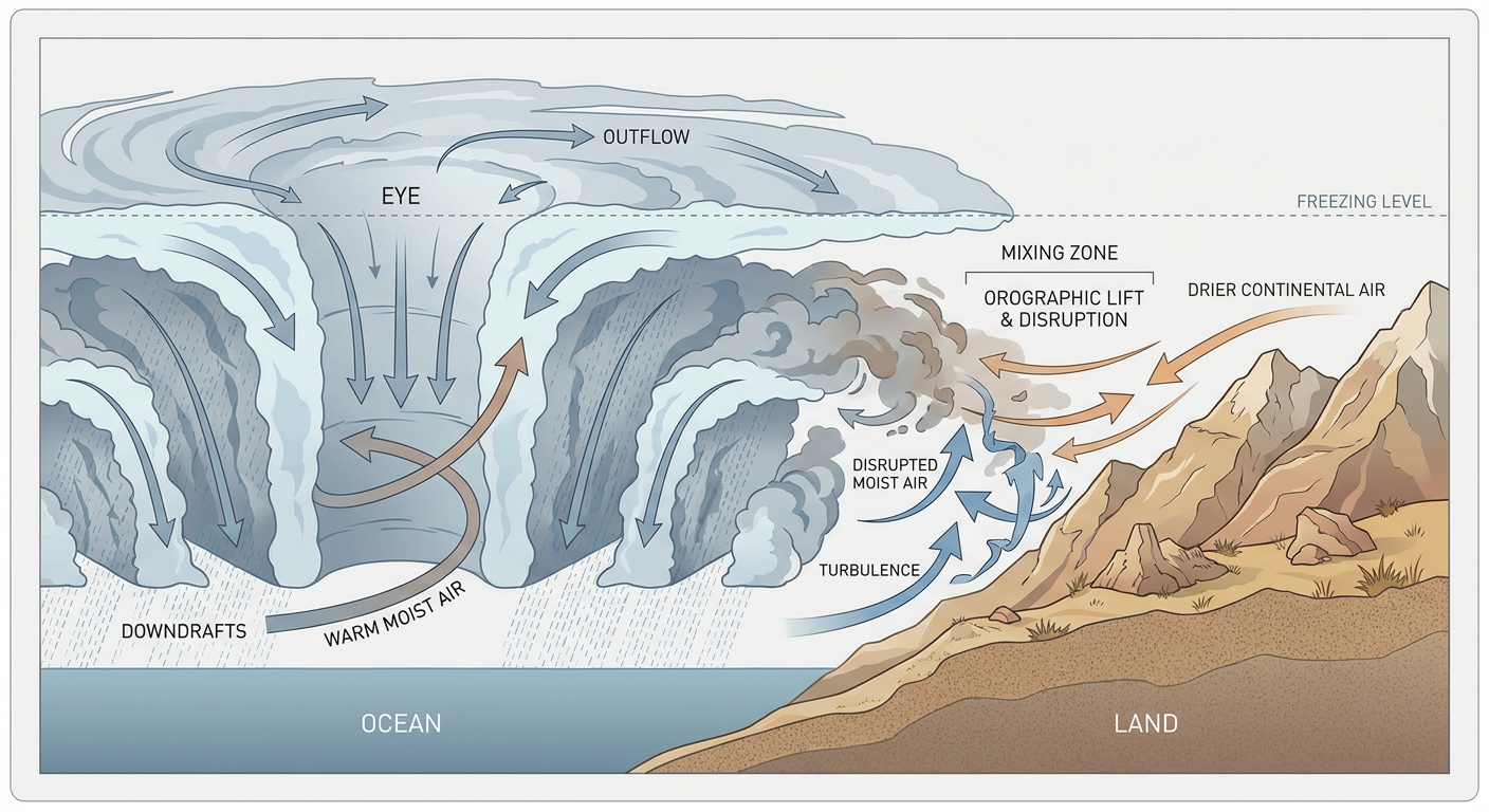
Get this. Simon's eye is still visible on satellite, but it's gotten cloud-filled and the surrounding cloud tops have warmed up. That's a hurricane's version of running out of gas. The reason is terrain. The Sierra Madre mountains run right along that stretch of Mexican coastline, and Simon's inner core has been brushing right up against them.
A hurricane needs a steady supply of warm, moist air flowing into its core to keep its engine running. When that core starts scraping against high terrain, the mountains disrupt the inflow and mix in drier air from the continent. Think of it like trying to keep a candle lit while somebody's blowing on it sideways. The flame doesn't go out immediately, but it gets ragged.
That's exactly what's happening to Simon. The subjective satellite estimate still has it around Cat 4 strength, but the objective intensity numbers have been falling. It's a storm fighting the coastline as much as it's fighting itself.
What this means if you've got a trip booked
Simon is forecast to keep sliding up the coast toward Mazatlan, with landfall there possible around midweek. By then, every bit of that mountain friction and a slower forward speed should have it weakening some from where it sits today. But Cat 4 right now is nothing to shrug at. Puerto Vallarta, San Blas, and Manzanillo are under Hurricane Warnings for a reason, and reconnaissance aircraft have been flying missions into this thing all weekend to nail down exactly how strong it is.
If you've got people in those towns, or you're the one with a flight landing in PV this week, don't go off a scary headline number. Go off the actual watch and warning. Right now that's a Hurricane Warning for the coast south of Mazatlan and a Hurricane Watch creeping north of it. Flights may shuffle. Resorts on that stretch of coast are almost certainly already moving to storm protocols.
Meanwhile, back home, we're bookending the continent
Here's the thing I keep coming back to this week. The East Coast just finished dealing with Isaias, and its post-tropical remnants are still wringing out rain over the Central Appalachians and Mid-Atlantic tonight, with another 1 to 3 inches possible on top of what already fell. The Southwest just got soaked by the remnants of Rachel, with a Moderate excessive rainfall risk tonight across the Great Basin. And now the Pacific side of Mexico has Simon.
Three named systems, one week, two different oceans. That's an active fall pattern, full stop. It's worth remembering that hurricane season doesn't wrap up just because the kids are back in school and the leaves are turning. Mid-October is still squarely inside the window, especially in the Eastern Pacific.
The takeaway
If a headline about a hurricane shows up in your feed next to your football scores, don't scroll past it just because it's happening somewhere other than Florida. Check the official advisory. Simon's real numbers are strong enough to matter for anybody with a Mexican Riviera trip on the calendar this week, mountains or no mountains.