Blog Article
Hurricane Trudy Update: Mexico Coast Soaked, US Fall Pattern Mild
Hurricane Trudy brings heavy rain to coastal Mexico as a new Atlantic low forms off the Southeast. Meanwhile, a beautiful fall day spreads across the Ohio Valley.

Hurricane Trudy Pulls Away From Mexico While a Textbook Fall Day Settles Over the Eastern U.S.
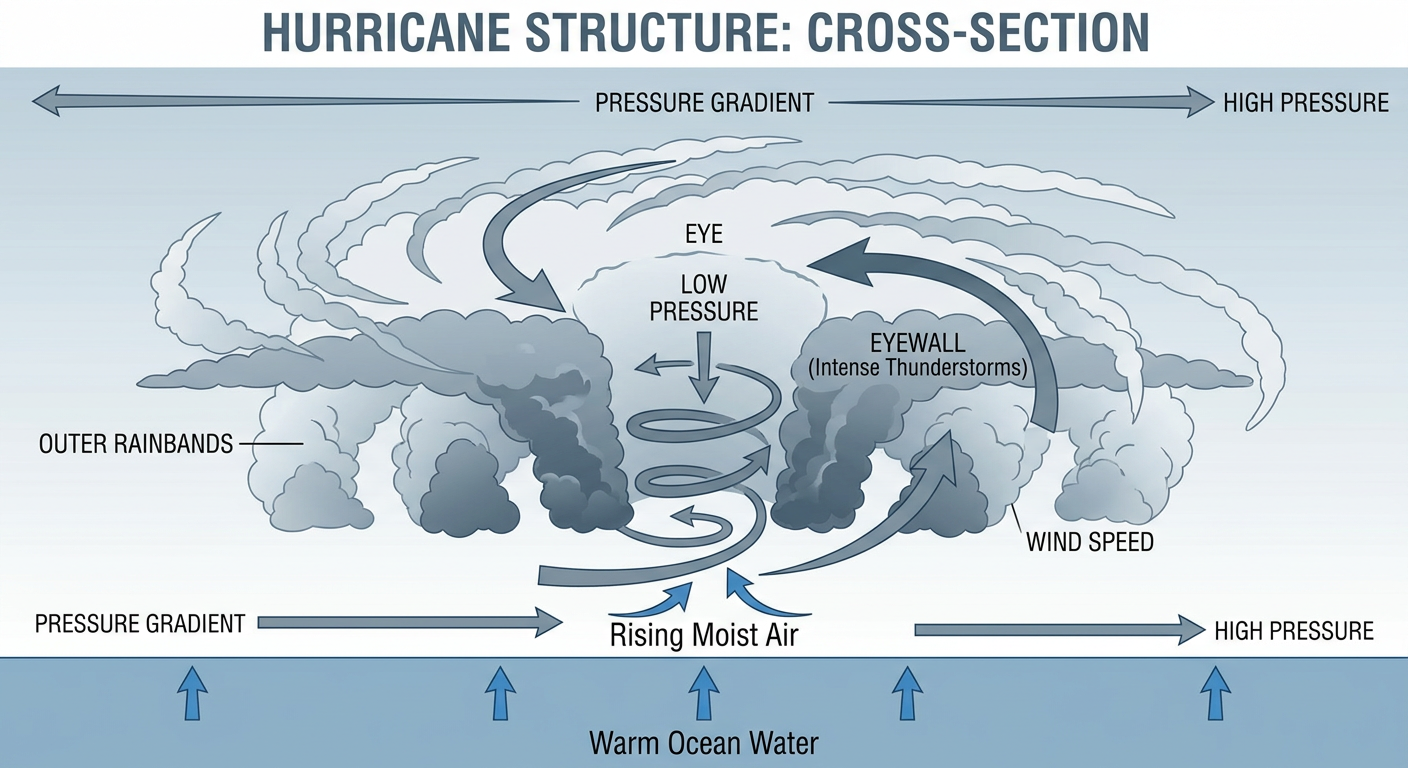
Alright y'all, let's start where the National Hurricane Center is watching closest. Hurricane Trudy is a Category 2 storm sitting about 135 miles southwest of Manzanillo, Mexico, with 105 mph winds and a central pressure of 970 millibars. This is the same storm that strengthened from a Cat 1 to a Cat 2 overnight, and it's the third named East Pacific hurricane to threaten that stretch of Mexican coastline this month, following Simon and Rachel earlier in October.
Trudy's Setup and Who Needs to Pay Attention
Trudy is moving northwest at 10 mph and the NHC's forecast keeps it offshore, with closest approach to Cabo San Lucas expected around Wednesday morning as a much weaker system near 29 mph winds. Mexico has Tropical Storm Warnings and a Hurricane Watch up from San Blas to Manzanillo, and the outer bands are already dumping heavy rain and whipping up strong winds across coastal Jalisco and Nayarit. The real concern there isn't the center of the storm, it's the rain. Mudslides, swollen rivers, and dangerous surf are the headline hazards for that stretch of coast through midweek.
For U.S. readers, Trudy itself is not a direct threat. But get this: NHC is also tracking a new area of low pressure forecast to form well offshore of southern Mexico in the next couple days, with an 80% chance of tropical development within a week. That's a HIGH confidence number on the seven-day timeframe, so don't be surprised if we're talking about a new East Pacific system by midweek. It's too early to know where it goes, but the Eastern Pacific has been unusually busy all month and this pattern isn't done yet.
A New Low Taking Shape Off the Southeast Coast
Here's the thing we're watching closer to home. NHC says a storm-force, non-tropical low is expected to form later today or tonight off the Southeast U.S. coast. It's forecast to move slowly and erratically through the middle of next week, and there's a low chance, about 30% over seven days, that it could pick up some subtropical characteristics. Even if it never gets a name, this system is expected to bring high winds, coastal flooding, and dangerous surf to the Atlantic coast, picking up right where yesterday's coastal flooding in Tyrrell and Carteret counties, North Carolina, left off. If you've got beach plans or coastal travel along the Carolinas or Mid-Atlantic this week, keep watching this one.
South Florida's Rain Risk Is Easing, But Not Gone
South Florida picked up 3.5 to 5.5 inches of rain yesterday in northern Broward and southern Palm Beach counties, enough to trigger a Flash Flood Warning and leave water over the curbs in Parkland and Deerfield Beach. Today, WPC has South Florida under a Marginal risk for excessive rainfall as a secondary cold front pushes through and redevelops thunderstorms. The ground is already saturated from yesterday, so even moderate rain rates could cause flash ponding in urban areas. The good news is the risk drops off sharply by Monday, with WPC keeping Day 2 and Day 3 probabilities under 5 percent as drier air works in behind that front.
The Bright Spot: A Genuinely Beautiful Fall Day
Now for some good news, because most of the country is not dealing with any of this. A strong 1037-millibar high pressure dome is parked over the eastern U.S. today, and it's producing what forecasters are calling a BEAUTIFUL-tier day, their top score outside of a technical PERFECT rating, across a corridor running from the Ohio Valley and Mid-South into the Northeast and High Plains. Think Columbus, Little Rock, and Burlington. Dry continental air with dewpoints in the upper 30s to low 40s, light winds, and abundant sunshine are the story here.
That's great timing if you're running the Columbus Marathon this weekend or heading to the Ohio Renaissance Festival in Waynesville. Flying is smooth too. Today's airport outlook calls for ideal conditions across nearly the entire mainland U.S., with the only real disruption sitting out in Hawaii, where gusty wind and scattered showers are bringing fair-category conditions to Maui and Kauai airports.
Monday keeps a similar flavor, with the BEAUTIFUL zone shifting to a patchwork across North Texas, the Ohio Valley and Great Lakes fringe, the Desert Southwest, and the Gulf Coast. If you're at the Texas Renaissance Festival in Todd Mission today or the Blues Festival in New Orleans, conditions should stay quiet, since neither sits anywhere near today's South Florida rain risk.
Other Things on Our Radar
- Fire weather: SPC's Day 2 outlook notes generally light winds across the Plains and lower Mississippi Valley should keep fire weather concerns in check, even with dry conditions persisting there.
- Space weather: Geomagnetic activity has been mostly quiet to unsettled. SWPC says conditions could build to G1 (Minor) storm levels late Monday into Tuesday as a positive-polarity coronal hole stream arrives, which could put a faint aurora in play for the far northern tier.
- Severe weather pattern change: SPC's extended Day 4-8 outlook flags a mid-level trough digging into the Interior West by midweek, with moisture working north into the Desert Southwest and High Plains by next weekend. Nothing organized yet, but it's the first hint of a pattern shift after a quiet stretch.
- Trudy's remnant impacts: Expect lingering rough surf, rip currents, and beach hazard concerns along the Mexican Pacific coast even as the storm itself weakens heading toward Baja by midweek.
Bottom Line
If you're on the Mexican Pacific coast from San Blas to Manzanillo, Trudy's rain and surf are today's main hazard, not the wind. If you're anywhere near the Southeast or Mid-Atlantic coast, start paying attention to that new low offshore, it's going to bring rough coastal conditions into next week regardless of whether it ever gets a name. South Florida should keep the umbrella handy one more day before things dry out. And for everybody else, especially from the Ohio Valley into the Mid-South and Northeast, today is about as good as fall gets. Get outside and enjoy it while it lasts.