Blog Article
Karina Becomes a Hurricane, Lowell Eyes Hawaii: Aug 30 Forecast
Hurricane Karina spins up in the East Pacific, Tropical Storm Lowell draws an aware flag for Hawaii, and Southwest flash flood risk continues. Full forecast breakdown.
Karina Becomes a Hurricane, Lowell Eyes Hawaii, and a Gulf Sleeper Worth Watching
Alright y'all, grab your coffee because the tropics decided to get busy overnight. We've got a fresh hurricane, a tropical storm with its eye on Hawaii, and a quiet little system sitting in the Gulf that deserves a glance even though it's not doing much yet. Let's get you caught up.
Karina Just Became a Hurricane
Karina officially got its hurricane card punched overnight. As of the 2 AM PDT advisory, Karina is a Category 1 hurricane with 80 mph winds and a central pressure of 980 millibars, sitting about 820 miles west-southwest of the southern tip of Baja California. It's moving WNW at 15 mph, and forecasters expect it to keep strengthening.
Here's the good news: Karina is way out over open water. There are no coastal watches or warnings in effect, and nothing in the data points to a US landfall threat. This one is purely a "watch it spin" storm for now, mostly relevant to shipping interests and anyone who likes a good satellite loop.
Lowell and the Hawaii Question
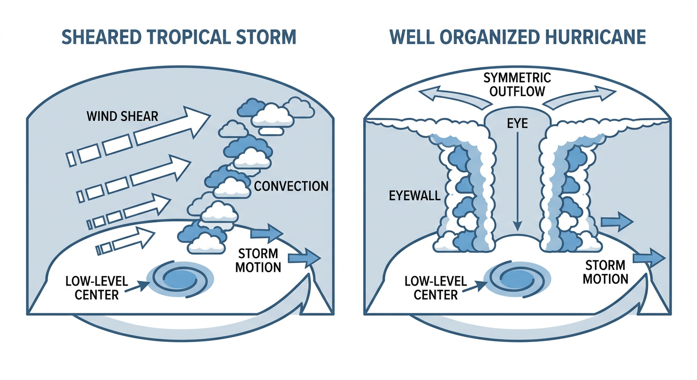
Tropical Storm Lowell is the one actually worth circling on your calendar, even though the timeline is long. Lowell is currently a 52 mph tropical storm about 1,150 miles east-southeast of Hilo, fighting through some easterly wind shear that's been keeping its convection displaced from the center. It's crawling west at 10 mph.
Our experimental RHY impact model has Hawaii Island (Hilo, the Kona Coast, the south and east flanks of the Big Island) flagged at an "aware" threat level, with a closest approach of roughly 64 to 99 miles depending on the exact spot, and that pass isn't expected for about eight days. The same model shows a max intensity near 92 mph at closest approach, which would put Lowell at hurricane strength by then if that track and intensity hold.
I want to be straight with y'all here: eight days out is a long time in tropical forecasting, and shear is already messing with Lowell's structure today. This isn't a "batten down the hatches" situation yet. It's a "if you've got Hawaii travel or you live there, keep half an eye on the Central Pacific Hurricane Center updates this week" situation.
The Gulf's Quiet Sleeper: Invest 97AL
Closer to home, keep a casual eye on Invest 97AL, sitting around 28.0N/88.7W, basically south of the Louisiana coast. Right now it's weak, 20 knots of wind and a pressure of 1014 millibars, nothing close to organized. It's drifting westward across the northern Gulf, and NHC has specifically told folks along the Upper Texas coast to keep tabs on it.
This isn't a system to worry about today. It's a system to be aware exists, especially with Houston and New Orleans already dealing with dangerous heat indices in the 100 to 104 degree range this week. If 97AL organizes at all, it'll be adding tropical moisture to an already steamy Gulf Coast pattern.
One more note for the islands: the remnants of former Tropical Storm Dolly are still tossing showers and storms at the northern Leeward Islands, Puerto Rico, and the Virgin Islands. NHC says redevelopment is unlikely as that wave moves west-northwest, but it's still worth an umbrella down there.
The Southwest Monsoon Isn't Finished Yet
Y'all, yesterday was a rough one for Utah and Arizona. We had 75 mph measured wind gusts near Big Water, Utah, evacuations at Phantom Ranch in the Grand Canyon, and flash flooding that hit the Paria River, Buckskin Gulch, and multiple slot canyons hard enough to force water rescues in Tucson. That pattern hasn't packed up and left.
WPC has a Slight Risk of excessive rainfall posted again today and tomorrow for central and northern Utah plus central and southern Arizona, with a deep trough pulling anomalous moisture into the Intermountain West and storms already showing signs of training over the same areas repeatedly. That's the exact recipe that caused yesterday's flooding. If you're anywhere near a slot canyon, wash, or burn scar in that corridor, this is not the week to test your luck.
Severe Storms: Marginal Today, a Slight Risk Building for Tuesday
Today's severe weather threat is modest. SPC has a Marginal Risk up across the northern Plains, parts of the central High Plains, and the eastern Great Basin, covering cities like Denver, Fargo, Rapid City, and Bismarck. The main threats are isolated wind and hail, nothing widespread.
Looking a few days out, Tuesday is the day to watch in the Northeast. SPC has posted a Slight Risk for the Lower Hudson Valley, with a broader Marginal Risk stretching from New York City to Chicago, Washington DC, and Detroit. An upper ridge centered over the Tennessee Valley will let multiple little disturbances ride around its edge into the Great Lakes and Northeast, and there's enough moisture and instability in place for a few storms capable of wind, hail, and even an isolated tornado.
- Today (Sunday): Marginal Risk, northern/central Plains and eastern Great Basin. Isolated wind and hail.
- Monday: Marginal Risk shifts toward Nebraska, the Dakotas, and into the Upper Midwest and nearby Great Lakes.
- Tuesday: Slight Risk for the Lower Hudson Valley, Marginal Risk from NYC to Chicago and DC. Watch for a warm front setup with a low-end tornado threat.
- All week: Southwest monsoon flash flooding continues, Slight to Marginal excessive rainfall risk through midweek.
Heat and Humidity Still Own the Midwest and Gulf Coast
If you've got a ballgame on the calendar today, plan around the sweat, not the rain. The Twins host the White Sox in Minneapolis, the Tigers host the Dodgers in Detroit, and the Guardians host the Royals in Cleveland, all in a corridor where apparent temperatures are running near 103 to 107 degrees according to today's forecast discussion. That's the kind of heat index that turns an afternoon game into a hydration test. Bring extra water if you're heading to any of these games or to outdoor festivals like the Renaissance Festival in Shakopee or the one up in Holly, Michigan.
Down on the Gulf Coast, Houston and New Orleans are both sitting under dangerous heat with indices in the 100 to 104 degree range, on top of average August highs that already run hot (Houston's normal high this time of year is 94, New Orleans sits at 91). Add the tropical moisture hanging around from Invest 97AL and this is a pattern where the heat, not the wind, is the real hazard.
Out at Burning Man in the Black Rock Desert, expect the usual dry desert extremes, big daytime heat and a sharp overnight cooldown, since that region sits well outside any of today's rain or storm chances.
A Little Extra Buzz Overhead
Quick space weather note since it's an active day up there too. SWPC says geospace conditions are active today because of a coronal hole high-speed stream plus the arrival of CMEs that left the sun on August 25 and 26. There's a chance of M-class solar flare activity today and tomorrow. None of this rises to a G1 geomagnetic storm, and SWPC's 27-day outlook shows no storm levels expected through mid-September. Aurora chasers at high latitudes might get a decent show tonight, but this isn't something the rest of us need to plan around.
Bottom Line
Nothing in today's tropical setup threatens the US mainland right now. Karina is a hurricane out over open Pacific water with no landfall forecast, and the Gulf's Invest 97AL is too disorganized to worry about yet, though Upper Texas coast folks should keep half an eye on it. Lowell's approach toward Hawaii is a longer-range watch item, roughly eight days out, with real uncertainty in both track and strength.
The stuff that actually affects your day: if you're in Utah or Arizona, respect the Slight Risk for flash flooding, especially in canyons and washes, after yesterday's rescues and evacuations. If you're catching a ballgame or a festival in the Midwest or Gulf Coast today, the heat index is the story, not severe storms. And if your travel plans run through the Lower Hudson Valley on Tuesday, keep an eye on that Slight Risk as it firms up.