Blog Article
Midwest Tornado Threat & High Plains Fire Danger Today
An Enhanced Risk for severe weather threatens Chicago and the Midwest today, bringing tornado and wind risks. Critical fire weather hits the High Plains.
Midwest Tornado Threat Today and Critical Fire Danger Down South
Alright folks, we saw some nasty storms tear through the Southern Plains yesterday. We had confirmed tornadoes in Texas and wind gusts clocking in at 75 mph. Today, that same storm system is setting its sights further north.
If you are flying through O'Hare or Midway today, or trying to catch a flight out of Milwaukee, expect some serious delays. The atmosphere is primed for trouble.
The Midwest Severe Threat Today
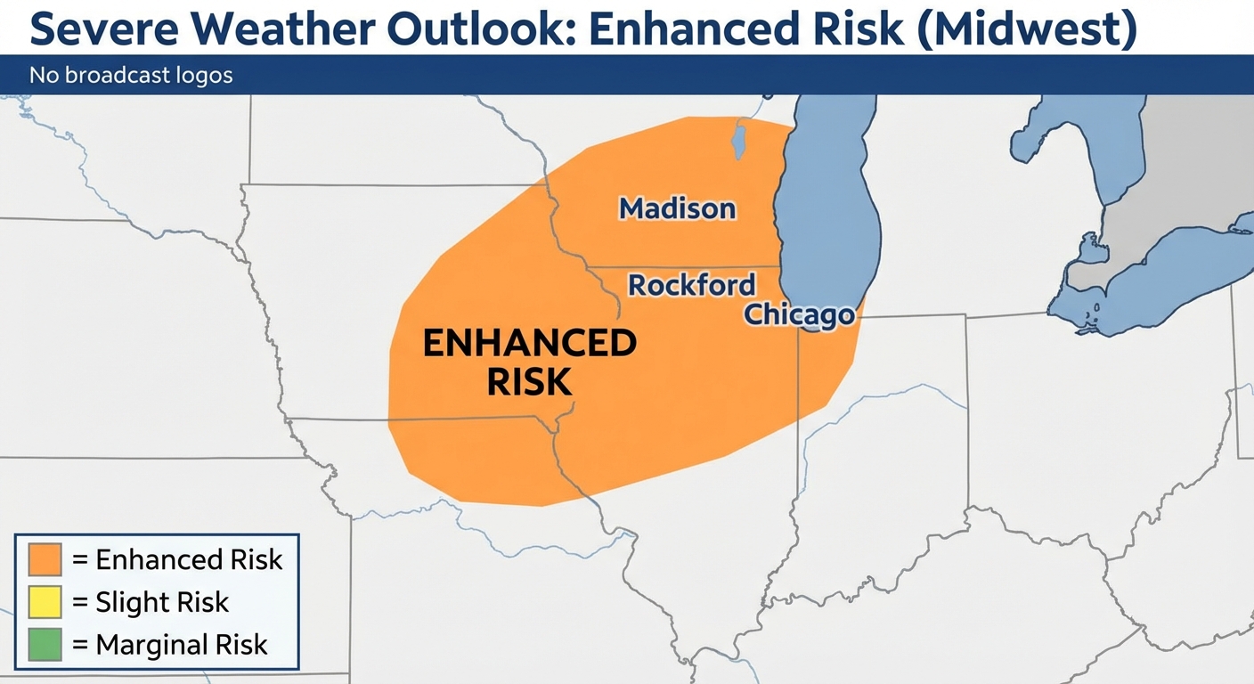
The Storm Prediction Center has an Enhanced Risk up for eastern Iowa, northern Illinois, and southern Wisconsin. If you live in Chicago, Rockford, or Madison, you need to pay attention today.
Temperatures are going to be warm ahead of this front, easily pushing past Chicago's normal high of 59 degrees. That warm, juicy air is going to fuel some strong thunderstorms this afternoon. The main threats are going to be damaging winds and a few tornadoes.
We are also watching a Marginal Risk for excessive rainfall right over the northern Chicago suburbs up into Milwaukee. Heavy downpours could cause some localized flash flooding. Give yourself extra time for your evening commute and do not drive through flooded roads.
Tomorrow's Squall Line
Get this. The threat does not end tonight. Tomorrow, we have another Enhanced Risk for southern Iowa and northern Missouri.
The data shows a massive squall line developing by late Friday afternoon. This line of storms will push toward the middle Mississippi Valley by the evening. When you have a squall line like this, widespread damaging wind gusts are your biggest problem. You can also get quick spin-up tornadoes embedded in the line.
Red Flag Warnings Out West
Down south, the severe storms have moved out, but the wind is still howling. We have a Critical Fire Weather area for the southern and central High Plains today.
The air is incredibly dry, and the winds are gusting. Any spark will spread a wildfire fast. Tomorrow, that critical fire threat shifts into central and eastern New Mexico. If you are out that way, avoid any outdoor burning.
Bottom Line
Have multiple ways to get warnings today, especially if you live near the I-90 corridor in the Midwest. Make sure your phone is charged and your weather radio has fresh batteries. Know where your safe room is before the sirens go off.
https://ryanhallyall.com/blog/midwest-tornado-threat-today-and-critical-fire-danger-down-south