Blog Article
Texas Flood Risk Rises as Two Pacific Hurricanes Spin Offshore
WPC posts a Moderate flood risk for the Lower Texas Coast as hurricanes Nolo and Rachel churn in the Pacific. Here's the setup, timeline, and who should watch out.

Moderate Flood Risk Settles Over the Texas Gulf Coast While Two Hurricanes Spin Harmlessly in the Pacific
Alright y'all, let's get right to it. The headline today isn't tornadoes or hurricanes making landfall, it's water. The Weather Prediction Center has bumped the Lower Texas Coast up to a Moderate risk of excessive rainfall for today into tonight, and that's the kind of flag we don't see every day. Here's what's going on and who needs to pay attention.
The Big Story: Flash Flooding Threat, Lower Texas Coast
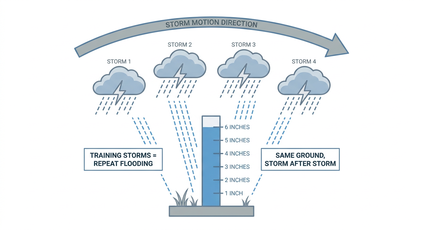
An inverted surface trough is sitting over the western Gulf with an embedded low tracking toward South Texas. That setup is funneling a deep plume of tropical moisture straight into the coast, and the atmosphere is primed for what forecasters call training convection, storms that form and move over the same spots again and again, like boxcars on a train track. When that happens, totals stack up fast.
WPC is advertising rates that could exceed 2 to 3 inches per hour at times, and local offices like Brownsville have flagged 3 to 6 inches as a realistic range, with isolated higher amounts possible where storms really park and train. That's enough to overwhelm poor-drainage areas fast, especially in Brownsville and McAllen, where urban and low-lying terrain floods quick.
This isn't a one-day problem either. WPC has a Slight risk posted for Day 2 (Monday into Tuesday) across that same lower Texas coast corridor, meaning today's rain could be compounding onto already saturated ground tomorrow. A surface front is expected to drift south into the Gulf and stall right along the coast, which is exactly the kind of boundary that keeps feeding storms into the same neighborhoods.
For context, Houston runs an average high of 82°F in early October and San Antonio sits right there too, so this isn't a cold rain. It's warm, tropical-fed moisture riding a stalled boundary, which is the classic recipe for flash flood emergencies along the Gulf Coast.
Florida Panhandle: Watching for a Few Spin-Up Storms
Farther east, SPC has a Marginal risk of severe weather posted for the Florida Panhandle today, including Panama City and Destin. The tornado probability is low, 2 percent, but that's enough for an isolated rotating storm near the coast given low cloud bases and a moist airmass. WPC also has a Marginal to Slight excessive rainfall risk layered on top there, with some guidance suggesting totals could run up to several inches where storms repeat. Tallahassee's local office has flagged up to 7 inches possible in the most persistent cells. Nothing here screams outbreak, but it's a coastal area worth a weather-radar check before you head to the beach.
Tropical Update: Pacific Stays Busy, Atlantic Stays Quiet
Out over open water, we've got two hurricanes spinning at the same time, Nolo and Rachel, both Category 2 strength with winds near 100 to 110 mph. Nolo is way out in the central Pacific, well west of Hawaii, tracking fast to the west and in the middle of an eyewall replacement cycle, basically the storm rebuilding its core. It poses no threat to land.
Rachel is closer to home, a few hundred miles southwest of the southern tip of Baja California, and it's actually still strengthening a bit. The good news is there are no coastal watches or warnings in effect, and the storm's closest approach stays offshore. Cabo San Lucas and San José del Cabo are in an "aware" tier on our impact model, which just means keep half an eye on it if you're down there, not a trigger to change plans.
Back in our own backyard, the Atlantic and Gulf are quiet. There's a broad area of low pressure that could try to form in the southwestern Gulf over the next several days, but NHC only gives it a 30 percent chance of development through 7 days, and it's not an organized system yet. The same goes for the Pacific disturbance south of Mexico, high development odds longer range, but that system is staying well offshore from US interests for now.
Out West: Heat and Fire Weather Linger
Southern California is dealing with its own anomaly this week, extreme heat warnings are up with highs pushing into the 90s to low 100s and overnight lows staying in the mid to upper 70s. That's a solid 15 to 20 degrees above the typical October high of 78°F for Los Angeles, which is a notable stretch for this time of year. Combine that heat with offshore flow and RH dropping into the 15 to 20 percent range, and SPC has an elevated fire weather concern for the terrain and foothills of southern California today, continuing into the northern Rockies on Monday as a mid-level jet kicks up downslope winds.
The Nicer Side of the Pattern
If you're looking for the pretty fall day, it's sitting in a narrow band from eastern Nebraska and South Dakota through Iowa into west-central Illinois today, crisp high pressure, sunshine, and dewpoints in the low 50s. That same general stripe shifts into southern Wisconsin and northeastern Iowa on Monday for what the data calls a genuinely PERFECT setup. By Tuesday, the best weather corridor stretches from north Texas through Indianapolis into the Carolinas and Mid-Atlantic, light winds, dry air, and plenty of sunshine.
Events on the Radar
Austin City Limits Weekend One kicks off today in Austin, and with the heaviest rain and flood risk centered well south along the coast, Austin itself should stay mostly dry, though keep an eye on any stray storms drifting up from the Gulf moisture plume. The Tulsa State Fair and the Pittsburgh and Michigan Renaissance Festivals are all running outdoor events today too, and those look to be in the clear with no severe or flooding concerns in their forecast areas. Folks headed to the Big E Festival in West Springfield, Massachusetts should have a quiet, rain-free day as well, since none of today's active systems reach into New England.
Key Factors We're Watching
- Training thunderstorms and flash flooding along the Lower Texas Coast, Moderate risk today, Slight risk continuing Monday
- A stalled frontal boundary keeping the Gulf moisture plume locked in place for multiple days
- Isolated rotating storms and heavy rain across the Florida Panhandle
- Hurricane Rachel's track off Baja California, currently no US impact expected
- Extreme heat and elevated fire weather risk continuing across Southern California
- The southwestern Gulf disturbance, only a 30 percent chance of development through 7 days, but worth watching given recent Gulf tropical activity this season
Bottom Line
If you're anywhere near Brownsville, McAllen, or the Lower Texas Coast, today is a legitimate flash flood risk day. Avoid low-lying roads, don't drive into standing water, and have a way to get flood alerts overnight since this threat runs through Monday morning and lingers into Tuesday. Florida Panhandle folks should keep half an eye on the sky for a stray rotating storm, but this isn't a widespread severe setup. Everywhere else, especially the Plains and Midwest, you're looking at a genuinely nice stretch of fall weather, so get outside while you can.