Blog Article
Midwest Severe Weather: Large Hail Threat Hits Ohio Valley
Project Hail Mary is trending online, but the real hail threat is hitting the Midwest and Ohio Valley this Thursday. Get the latest severe weather updates.

Nature's 'Project Hail Mary': Why the Midwest Needs to Watch the Skies
Alright folks, I was looking at the internet trends this evening and saw that "Project Hail Mary" is blowing up online. People are getting super excited about the new sci-fi movie adaptation. But here is the thing. Mother Nature is currently cooking up her own version of a hail mary for the Midwest and Ohio Valley later this week.
We have been dealing with some truly wild weather whiplash this month. From historic 35-inch blizzards up in Michigan to 141 mph wind gusts out in Wyoming, it feels like the atmosphere is throwing everything it has at us. Now, the focus is shifting to a classic springtime clash of airmasses.
The Real-Life Hail Threat
Let me break this down for you. The Storm Prediction Center has highlighted a Slight Risk for severe storms covering over 73,000 square miles for Thursday into Friday morning.
If you live in Illinois, Indiana, or western Ohio, you need to pay attention.
- The Target Area: Cities like Indianapolis, Columbus, Cincinnati, Fort Wayne, and Dayton are right in the bullseye.
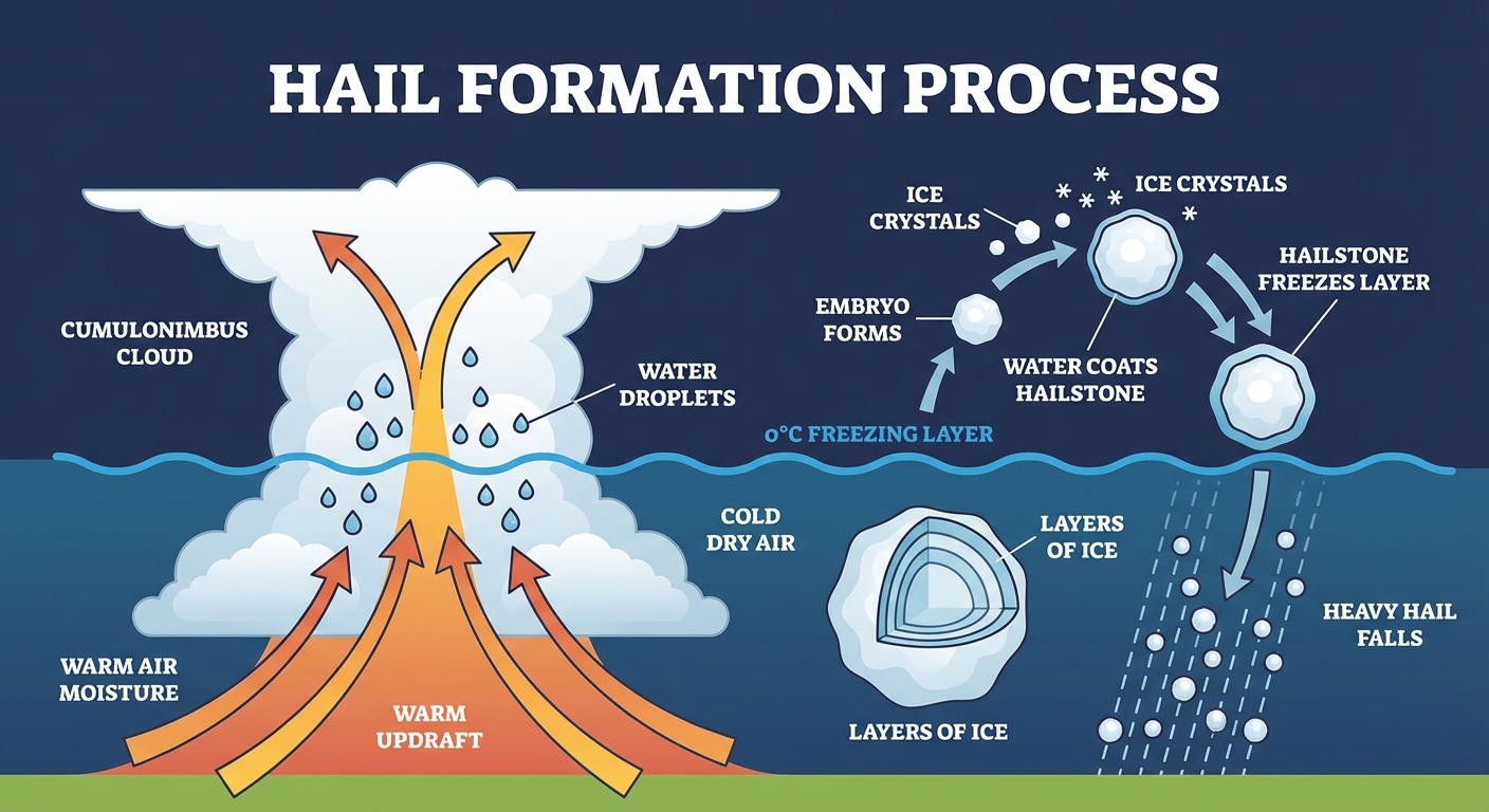
- The Main Hazard: The data specifically points to a likelihood of very large hail.
- The Secondary Threats: We are also looking at the potential for damaging wind gusts and a few tornadoes.
The Giant Battery Out West
Why is this happening? Well, we have a massive thermal contrast setting up across the country. Out in the Central Plains, we are seeing absolutely record-breaking heat. We are talking about temperatures pushing into the upper 80s and 90s in places like Nebraska and Oklahoma. That is 30 to 35 degrees above average for late March.
That heat is basically turning the atmosphere into a giant battery. When an intense upper-level trough swings out of the northern Plains and sweeps across the Great Lakes on Thursday, it is going to tap into all that stored energy.
Fire and Wind
We also can not forget what that dry, intense heat is doing further west right now.
Because of this setup, we have Critical Fire Weather areas for Wyoming, western Nebraska, and extreme southwest South Dakota. The humidity out there is dropping as low as 11 percent, and the wind is howling with gusts up to 50 mph. Given how dry the fuels are, any spark could turn into a massive problem. We saw this earlier this week with the Twenty-Four Fire in Colorado exploding to over 7,000 acres, so please take those Red Flag Warnings seriously.
What This Means For You
Here is the bottom line, y'all. If you are in the Ohio Valley or the Midwest, Thursday evening is not the time to leave your car parked out in the driveway. Clear out the garage, tie down your patio furniture, and make sure you have multiple ways to get weather alerts that will wake you up if a storm rolls through after dark.
We will be watching this setup very closely over the next 48 hours. Keep your eyes on the skies, not just the movie screens. Have a great night, and I will see y'all in the morning with a fresh update.
https://ryanhallyall.com/blog/natures-project-hail-mary-why-the-midwest-needs-to-watch-the-skies