Blog Article
Beautiful Weather Marches East: 3-Day Nice Weather Parade
Canadian high pressure brings Beautiful-category weather from Minneapolis to Boston over three days. Northern California keeps a 14-day streak alive. Plan your outdoor window.
The Comfort Zone Marches East: A Three-Day Beautiful Weather Parade
Y'all, if you live anywhere along the northern tier from Minneapolis to Boston, this is your week. A slug of Canadian high pressure is rolling eastward and delivering three consecutive days of top-tier outdoor weather, each one landing on a different region. Today the Upper Midwest cashes in. Tomorrow the Great Lakes and Ohio Valley get their turn. Wednesday the Northeast and Mid-Atlantic step into the spotlight.
And while all that is happening, Northern California just keeps doing its thing. More on that in a minute.
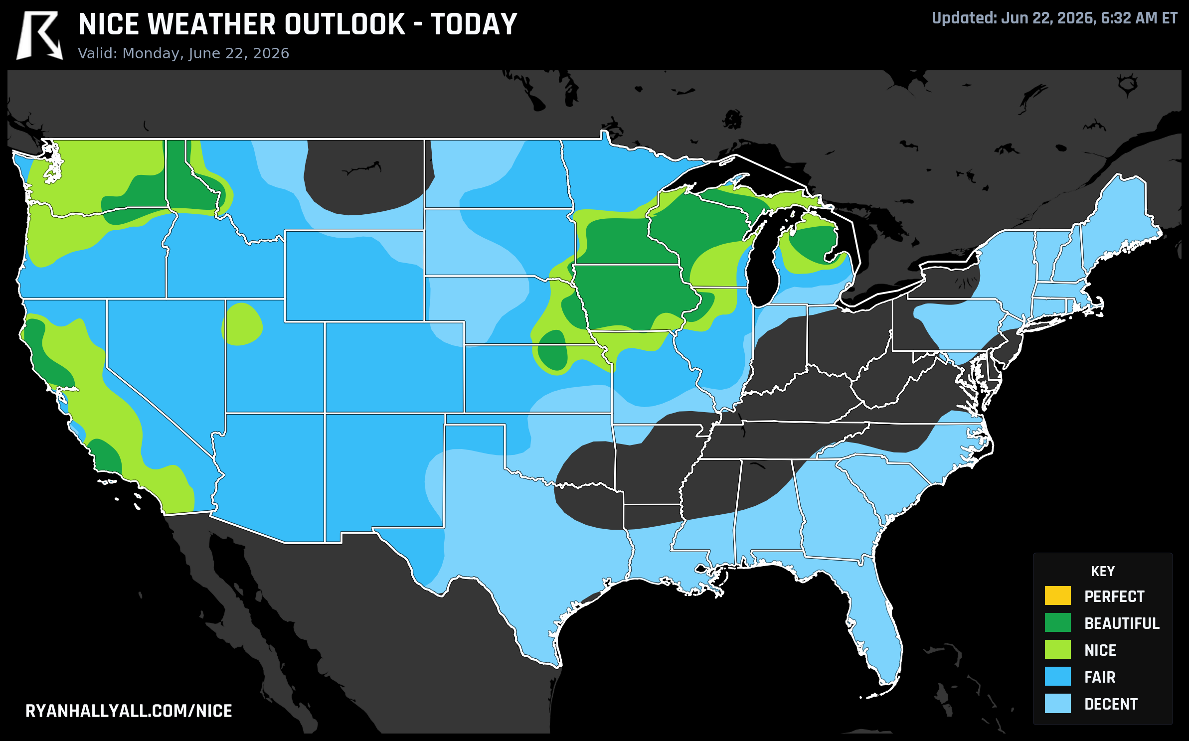
Today: Upper Midwest Takes the Crown
The best weather in the country right now is sitting over Minnesota, Iowa, the Dakotas, and eastern Nebraska. Minneapolis scores a 92, good enough for Beautiful. So does Des Moines, Sioux Falls, Cedar Rapids, Rochester MN, and Davenport. Even Omaha lands in the Beautiful tier.
We are talking highs in the mid-70s, dewpoints around 50 degrees, light winds under 10 mph, and barely a cloud in the sky. After the brutal severe weather the Midwest has endured this June, this is the kind of day that makes you want to call in well.
If you are heading to Target Field tonight, the Dodgers are in town to play the Twins. First pitch is at 6:40 PM local time and you could not ask for better baseball weather. High of 74, dropping into the mid-60s by the late innings, dewpoint in the upper 40s. Bring a light layer for the eighth inning and you are set.
One caveat: UV indices are running 7.5 to 8.2 across this zone. That is high enough to warrant sunscreen if you are out for prolonged exposure, especially on a patio or trail between 11 AM and 3 PM. The air is dry and clean, which is great for comfort but also means the sun hits harder than it feels.
The Tri-Cities area in Washington also scores a 92 today, with a high of 88 and a dewpoint of 45. Out in Santa Rosa, California, the score hits Beautiful as well, though UV there is 8.2 and climbing.
Tuesday: Great Lakes and Ohio Valley Step Up
Tomorrow the high pressure shifts east and the Beautiful zone slides right over the Great Lakes and into the Ohio Valley. Indianapolis, Toledo, St. Louis, Fort Wayne, Madison, Grand Rapids, and Rockford all land at 92.
Indianapolis is the standout. High of 75, dewpoint of 61, light winds at 9 mph, and zero rain chances. That is a patio breakfast kind of morning followed by a long lunch outside kind of afternoon. Toledo hits 77 with a dewpoint of 59. St. Louis reaches 81, which is a touch warmer but still comfortable with dewpoints in the low 60s.
Milwaukee sits a notch lower at 82 on the score sheet, and Chicago will be cooler still thanks to that persistent onshore flow off Lake Michigan. Lakeside areas in the Chicago metro will struggle to get out of the 60s while inland spots reach the mid-70s. If you are in Chicago and want warmth, head west. If you want a cool breeze, stick to the lakefront.
Late in the afternoon, a few isolated showers or storms could bubble up west of the Mississippi as a shortwave approaches. The NWS offices in Des Moines and the Quad Cities are flagging this as a low-confidence feature, but if you are planning an evening walk in eastern Iowa or southern Minnesota, just keep an eye on the sky after 5 PM.
Wednesday: Northeast and Mid-Atlantic Get Their Day
By Wednesday, the high pressure settles over the Northeast and Mid-Atlantic. This is the day that the Nice Weather outlook page really lights up from Pittsburgh to Boston to DC.
Pittsburgh, Springfield MA, Allentown PA, Erie PA, Albany NY, Lynchburg VA, and Scranton PA all score 92. Washington DC lands at 82, right at the Beautiful threshold, with a dewpoint of 59 and an AQI of 48 that is just two points under the gate.
Highs across the Northeast will be in the 70s, which is seasonable to slightly below normal for late June. Dewpoints drop into the mid-50s behind the dry northerly flow. Winds will be light at around 8 mph. Mostly sunny skies with about 23% cloud cover on average. Rain chances are effectively zero.
This is the day to plan a long lunch outside if you work anywhere from the Hudson Valley down through the Shenandoah. Or if you have been putting off a hike, Wednesday is your window before rain and thunderstorm chances return Thursday and Friday.
One thing to watch: air quality. DC's AQI of 48 is close to the gate. Urban centers along I-95 could see AQI creep up into the low 50s, which would cap those areas at Fair rather than Beautiful. The cleaner air will be in the smaller cities and higher elevations.
Meanwhile, California Does Not Stop
While the northern tier gets its three-day parade, Northern California is on day 14 of an unbroken nice weather streak. Ukiah, Redwood Valley, Santa Barbara, San Luis Obispo, Cloverdale, Willits, Lakeport, and a long list of other California towns have been logging nice or better conditions every single day since June 9.
The weekly top cities list is dominated by the North Coast and Central Coast. Ukiah leads with a mean score of 86.3 across all seven days. Santa Barbara, Goleta, Montecito, and Carpinteria all average around 85. These are places where the marine layer keeps things cool enough to be comfortable but not cold, and the dry interior air keeps dewpoints pleasant.
Now, there are caveats. Interior valleys like Redding are seeing highs near 100, and AQI there is running 75, which is well above the comfortable threshold. The San Joaquin Valley is heading into triple digits by midweek. Los Angeles has an AQI of 80 today, which is poor enough to cap it at Fair despite the comfortable temperature. So the California nice zone is really a coastal and near-coastal story, not a statewide one.
Fire weather is also a growing concern. The SPC has Elevated fire weather highlights across the southern Great Basin into the Four Corners today, and a Critical designation for portions of northern Arizona into southern Utah on Tuesday. If you are planning outdoor activities in the Intermountain West, check local fire restrictions before you go.
The Bottom Line
The next three days offer a traveling window of genuinely beautiful weather from the Upper Midwest to the Northeast. Each region gets one day. After that, the pattern gets more complicated, with an active convective corridor setting up from the Central Plains into the Midwest and Northeast by Thursday.
So if today is your day in Minneapolis or Des Moines, get out there. If tomorrow is your day in Indianapolis or Toledo, make a plan. And if Wednesday is your day in Pittsburgh or Albany, do not waste it. You can check the full Nice Weather outlook for your specific location and day-by-day breakdown.
June has been a rough month for a lot of the country. Take the nice days where you can get them.