Blog Article
Best Weather of the Week: Ohio Valley and East Coast Today
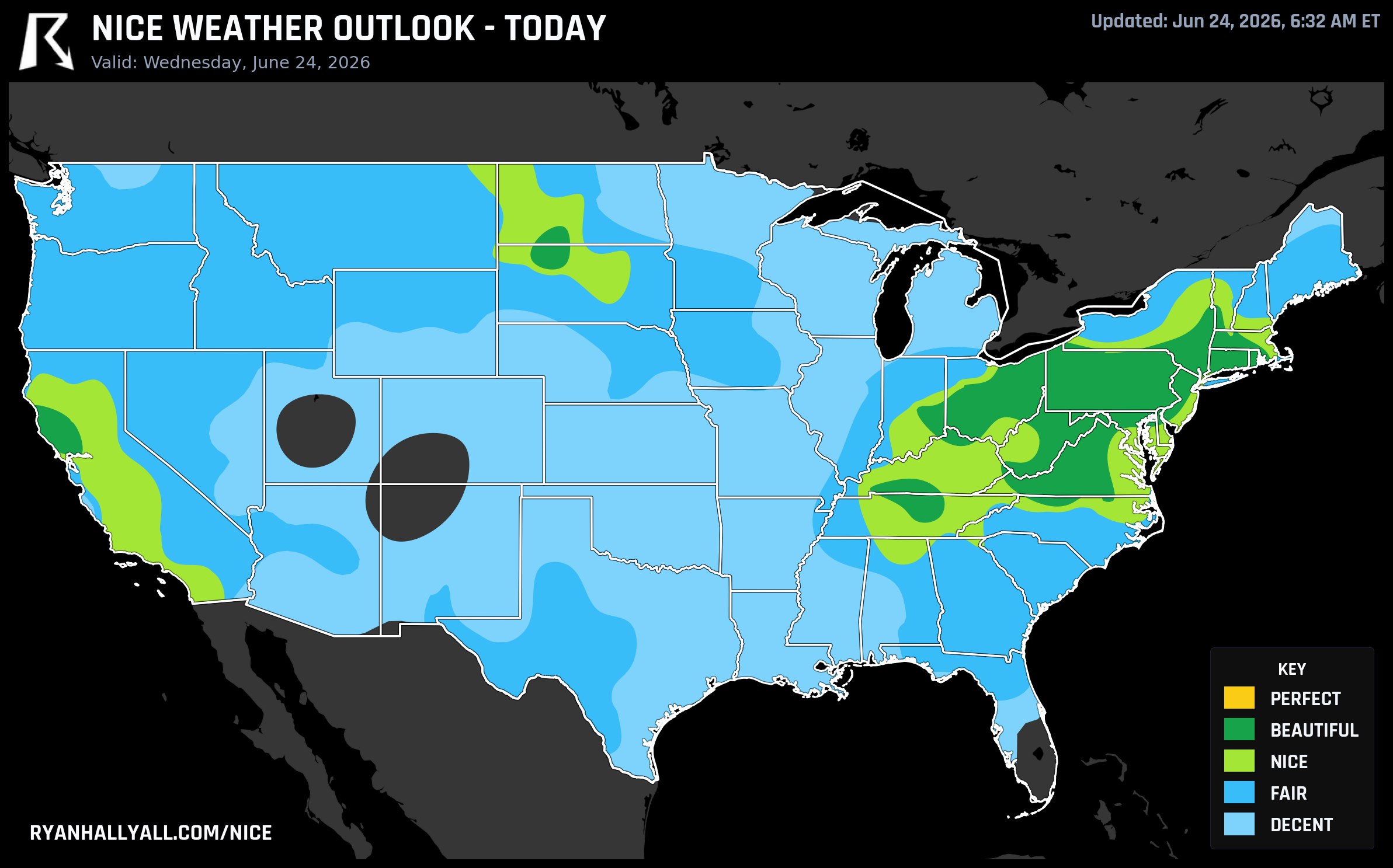
A Canadian high is delivering Beautiful-category weather across the Ohio Valley and Mid-Atlantic today, with scores of 92 in Philadelphia, Pittsburgh, and Cincinnati. Here's how long it lasts.
Today Is the Peak: The East Coast and Ohio Valley Are Having Their Best Day of the Week
Yesterday was a rough one in a lot of places. Flash flood emergencies in Oklahoma, severe storms tearing through the Mid-Atlantic, water rescues in West Virginia. All of that is still fresh. Which makes today feel like an exhale, at least if you're east of the Appalachians or in the Ohio Valley.
This is the day to be outside. The data says so clearly.
What's Actually Happening Today
A Canadian high-pressure system has settled over the region and is doing exactly what you want a high to do in late June: scrubbing the humidity down, clearing the sky out, and keeping the wind light. Dewpoints across the Ohio Valley and Mid-Atlantic are running in the mid-to-upper 50s, which is genuinely comfortable air for this time of year. The precipitation sub-score for the Beautiful zone is 99.6 out of 100. That's essentially zero rain chance.
Philadelphia hits a high near 83°F with a dewpoint around 56°F, clear skies, and winds only around 10 mph gusting to 19. Score: 92 out of 100, Beautiful category. Pittsburgh is nearly identical. Cincinnati comes in at 79°F with a dewpoint of 57°F and a gust of just 8 mph, one of the calmest afternoon readings you'll see in the Ohio Valley all summer. Columbus, Akron, Dayton, Clarksville, Providence, Hartford, Allentown, Albany — all of them are scoring 92 today, and today is their best day of the entire seven-day outlook.
The only reason none of these cities crack the Perfect tier is two modest gate failures: UV index averaging around 7.7 across the zone (the Perfect gate requires 7.0 or below), and AQI readings in the 41 to 50 range (Perfect requires 35 or below). Neither of those is alarming from a health standpoint, but both are real. Wear sunscreen during peak afternoon hours, especially in Northern California, where Santa Rosa is posting UV 8.2.
For what it's worth, Santa Rosa, CA is also in the Beautiful zone today at 92 out of 100, with a 76°F high and a dewpoint of 55°F. That's a nice bonus for the Bay Area fringe.
The Baseball Angle Is Real Today
A few games tonight line up almost perfectly with the best weather. The Seattle Mariners at Pittsburgh Pirates at PNC Park is one of the better outdoor ballpark setups in the country tonight. Pittsburgh scores 92 today, with light winds and low humidity. The Phillies at Nationals in Washington is another one worth noting — the Washington DC area is sitting in the Beautiful zone, and first pitch is evening, which means the worst of the UV is already past. Both games are worth the walk to the park.
The Yankees at Tigers in Detroit is also in decent shape, though Detroit sits a step below the Beautiful core — closer to Fair territory once you get into the metro. Still a fine evening.
Tomorrow: The Upper Midwest Gets Its Turn
Today's high slides east and weakens slightly overnight, and by Thursday the best weather in the country has relocated to a corridor from the eastern Dakotas through the Twin Cities and down into the upper Mississippi Valley. The overall Beautiful-zone score for that region on Thursday is 91.1 out of 100 — just barely below today's peak, but still excellent.
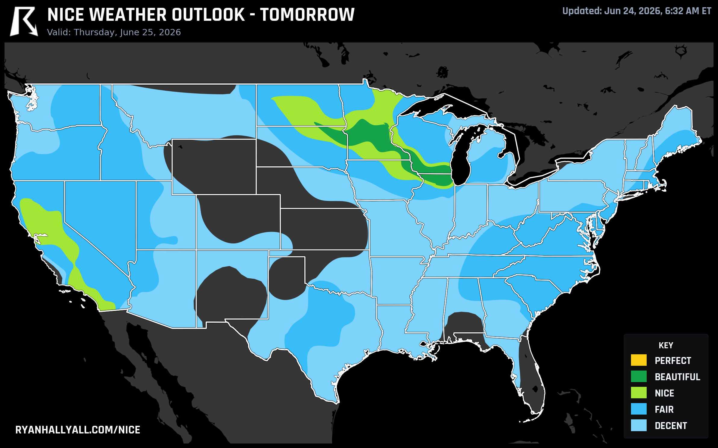
Dubuque, Iowa leads the day with a score of 92, posting a high of 77°F, a dewpoint of 58°F, and a precipitation chance of just 1%. La Crosse, Wisconsin and St. Cloud, Minnesota are close behind. Minneapolis scores 82, held there mostly by a UV index of 7.2 that's right at the edge of the Perfect gate and an AQI that just clears 40. The precipitation sub-score for the whole zone Thursday is a perfect 100 out of 100. Post-frontal high pressure over the Lake Superior region has scoured the boundary layer clean.
This is also the opening day of Summerfest Weekend 2 in Milwaukee. Milwaukee's score Thursday is 64.3 — Beautiful category but the weakest city in the zone, dragged down by dewpoints around 60°F and 43% cloud cover. It's not a bad day for the festival by any measure, but if you're driving up from Chicago, know that the cleanest air Thursday is actually a couple hours northwest, not right on the lakefront.
Electric Forest up in Rothbury, Michigan also opens Thursday. Rothbury is in the Upper Midwest zone that benefits from Thursday's post-frontal high, though it sits a bit east of the core. Conditions should be comfortable with low humidity and minimal rain chances.
The Rest of the Week: It Gets Harder
Friday through the weekend is where the pattern gets complicated. A trough dropping out of the Northwest starts reorganizing things. The WPC has Slight Risks of excessive rainfall stacked through the Ohio Valley on Friday and Saturday. Heat and humidity begin building across the Central and Southern US starting this weekend, and by next week the CPC is flagging a High Risk of extreme heat for parts of the Mid-Atlantic.
The best weather from Friday onward retreats to two corridors: Southern California and pockets of the Upper Midwest on Friday, then the Great Lakes (Milwaukee, Green Bay, Grand Rapids) on Saturday before the pattern shifts the focus to the West Coast for Sunday through Tuesday. None of those days reach Beautiful under the forecast-day caps, and the scores reflect it — the Great Lakes zone Saturday scores 80.9 out of 100, which is genuinely nice but a clear step below today.
If you're in the Ohio Valley or Mid-Atlantic and you've been waiting for a clean summer day to do something outside, today is the answer. The Nice Weather outlook page has the full map and city-level scores if you want to check your specific zip code before you commit to that patio dinner or evening trail run.
Enjoy it. The window is real, and it's today.