Blog Article
Best Weather Today: Sacramento and Albany Score Beautiful
Sacramento and Albany hit Beautiful today with dry air and clear skies. Here's where the nice weather holds and what the July 4th heat wave means for your week.
California and Albany Are Living Their Best Life While the Rest of the Country Braces for Heat
If you're in the Sacramento Valley or anywhere around Albany, New York this Sunday morning, step outside. Take a moment with your coffee on the porch. Because today is the best day on the map, and by this time next week, most of the country is going to be deep in a heat wave that won't be easy to forget.
Let's talk about what's actually happening today, and then what it means for the rest of the week.
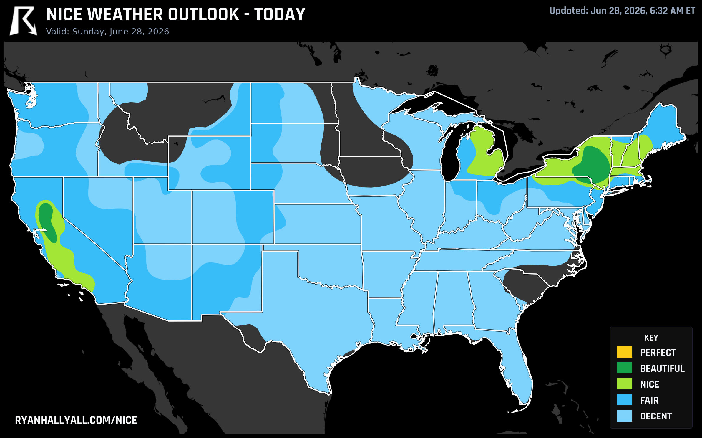
Today's Top Tier: Sacramento and Albany, Both Beautiful
The Sacramento Valley and the Albany area are sitting at Beautiful today — scores of 92/100 — and they got there through completely different atmospheric setups, which is worth appreciating.
In the Sacramento Valley, an upper-level trough parked along the West Coast is keeping temperatures well below late-June norms. Sacramento tops out around 85°F with a dewpoint of just 51°F. Stockton and Modesto are even drier, with dewpoints near 48°F and essentially zero cloud cover. The air quality reads 40 to 45 AQI. This is the kind of afternoon where a patio lunch or a long ride on a bike trail just feels effortless — not because it's cool, but because the air is genuinely dry and the sky is open.
In Albany, the story is high pressure ridging, low dewpoints in the upper 50s to low 60s, and light winds around 6 mph with gusts barely reaching 9. High of around 81°F. Binghamton and Utica are right there with it. The afternoon at a park or a farmers market in the Hudson Valley corridor is about as comfortable as late June gets in the Northeast.
One honest caveat for both zones: UV indices are running 8.0 to 8.2 across these cities. That's the single reason neither zone reaches Perfect today — the scoring system requires UV at or below 7 for that top tier, and there's no getting around midsummer sun at these latitudes. Sunscreen matters if you're spending a few hours outside.
For the Northeast, NWS forecasters noted this as essentially the last day of comfortable humidity before conditions change. Dewpoints stay in the 50s and low 60s today. That window closes.
Monday: Maine Gets Its Moment
The high pressure that's giving Albany a nice Sunday slides northeast overnight, and Monday it's coastal Maine's turn. Portland and Bangor both score Beautiful on Day 2, with Portland reaching a high of around 73°F and dewpoints still in a tolerable range. The Sacramento Valley holds on too — Sacramento, Stockton, and Modesto stay Beautiful on Monday with precipitation scores of 100/100 and winds averaging around 7 to 8 mph.
If you're in Portland, Maine on Monday, that's a legitimately good day for anything outdoors. The heat wave that's about to grip the rest of the eastern seaboard hasn't arrived yet. Enjoy it.
Tuesday: The Best Weather Shifts to Oregon and Northern California
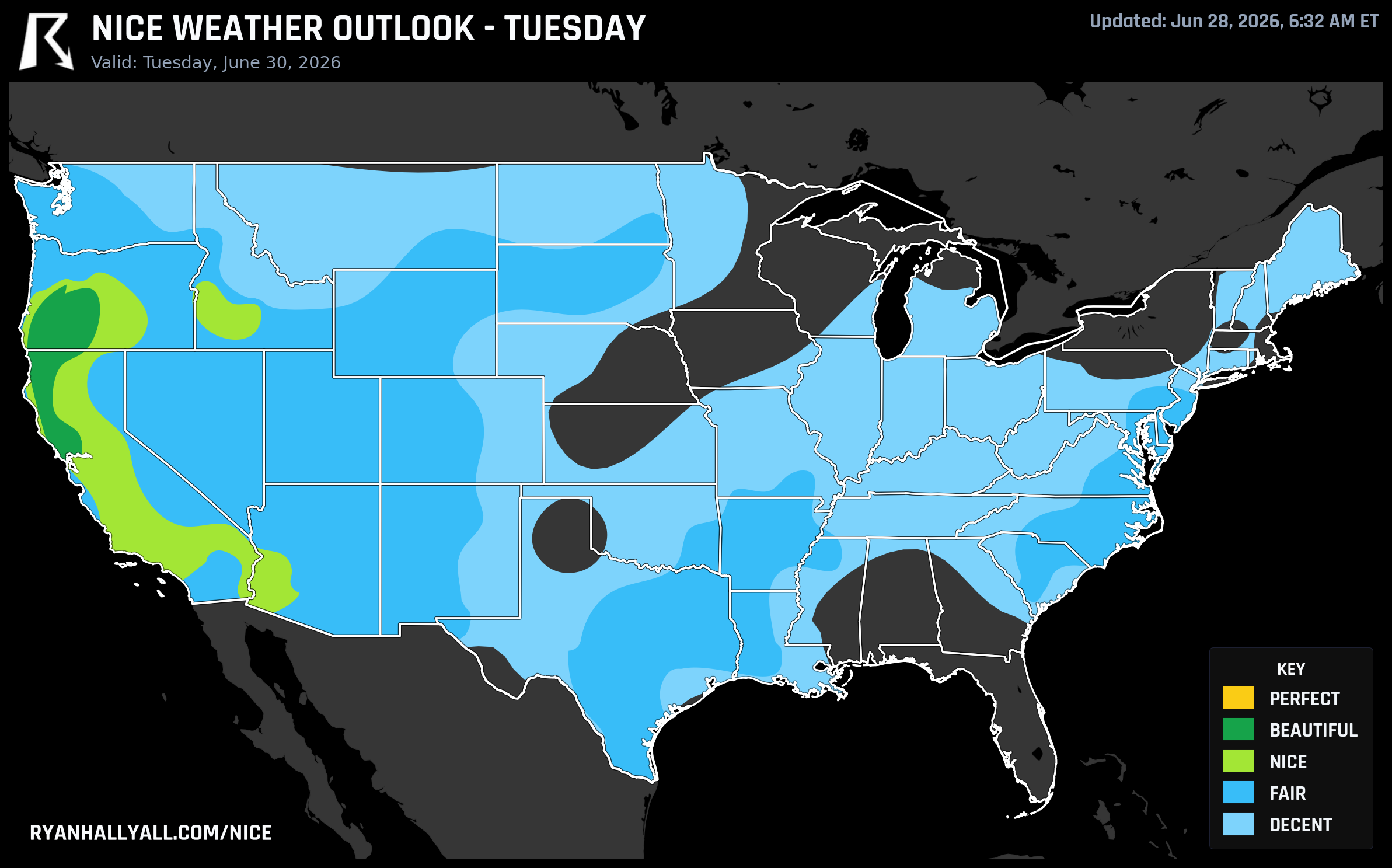
By Tuesday, the Northeast has already started warming and muggying up. The best outdoor comfort in the country moves to a corridor stretching from Santa Rosa and Hayfork in Northern California northward through Medford and Bend, Oregon — all landing in the Beautiful category with an overall zone score of 88/100.
Medford stands out: 73°F high, dewpoint of 45°F, 9 mph winds, and a score of 92/100. Bend is even drier at 40°F dewpoint with only 4% cloud cover. These are genuinely excellent conditions for hiking, outdoor dining, or anything you want to do outside. The precipitation probability across the whole zone is 1% — essentially zero.
This is a useful travel window if you have flexibility. The Pacific Northwest and Northern California are doing their quiet summer thing while most of the country is sweating through a heat wave.
The Bigger Picture: Heat Builds and the Map Shrinks
Starting Wednesday and running through the Fourth of July, a strong upper-level ridge anchors over the eastern half of the country and drives a prolonged, dangerous heat wave. The WPC is calling it significant and record-breaking for parts of the central and eastern U.S. Dewpoints in the low to mid 70s, heat index values potentially exceeding 100 to 105°F across a wide area, and overnight temperatures staying warm enough to limit recovery.
Philadelphia is forecast to hit 100°F on July 1 with a dewpoint of 73°F and an AQI of 120 — that's Unhealthy for Sensitive Groups. San Antonio pushes close to 98°F with similar humidity. The eastern two-thirds of the country drops to Decent or below on the nice weather scale for the rest of the period.
The only geography holding onto Nice conditions through the holiday weekend is the West Coast and Intermountain West — California, Oregon, and parts of the Pacific Northwest. Los Angeles, San Jose, Portland (Oregon), and Seattle all appear in the top-10 city rankings on July 4th. Dewpoints out there stay in the low to mid 40s. It's not Beautiful, but it's comfortable by comparison.
For the National Independence Day Parade in Washington, D.C. on July 4th, the data is not encouraging. D.C. sits in the Fair zone at best, with the broader mid-Atlantic locked in the heat wave. If you're attending, plan for heat, humidity, and afternoon storm potential — that's the pattern.
The Weekly Winner: The Santa Barbara and Ventura Coast
If you zoom out and look at the full seven-day picture, the top weekly rankings belong to the Santa Barbara and Ventura County coast. Ventura and San Buenaventura both post a mean score of 86.3 over the week with 7 out of 7 days scoring Nice or better. Santa Barbara is right there with 6 out of 7 days. This stretch of coastline — buffered by marine air, moderate temperatures, and dry inland flow — is simply the most consistently comfortable geography in the country right now.
For a full look at where the nice weather sits day by day, check the Nice Weather outlook page.
Quick Scoreboard for the Week
- Today (Sunday, June 28): Beautiful in Sacramento Valley and Albany, NY. Use the sunscreen.
- Monday (June 29): Beautiful holds in Sacramento Valley; coastal Maine joins the top tier.
- Tuesday (June 30): Best conditions shift to interior Oregon and Northern California (Medford, Bend, Santa Rosa).
- Wednesday through July 4th: Nice weather confined to the West Coast and Intermountain West. Everywhere else is heat wave territory.
If you're east of the Rockies and have outdoor plans this week, today and tomorrow are your windows. After that, the calendar and the atmosphere are working against you for a while.