Blog Article
Best Weather July 4 Week: California's 22-Day Streak
California and the Pacific Northwest are hitting peak comfort on June 30, leading a 22-day nice weather streak heading into the Fourth of July holiday weekend.
California Just Ran a 22-Day Nice Weather Streak Into the Fourth of July
While most of the country is bracing for a heat wave that forecasters are calling significant and record-breaking, the West Coast is doing something quietly impressive: it has been comfortable for three straight weeks and is showing no real signs of stopping.
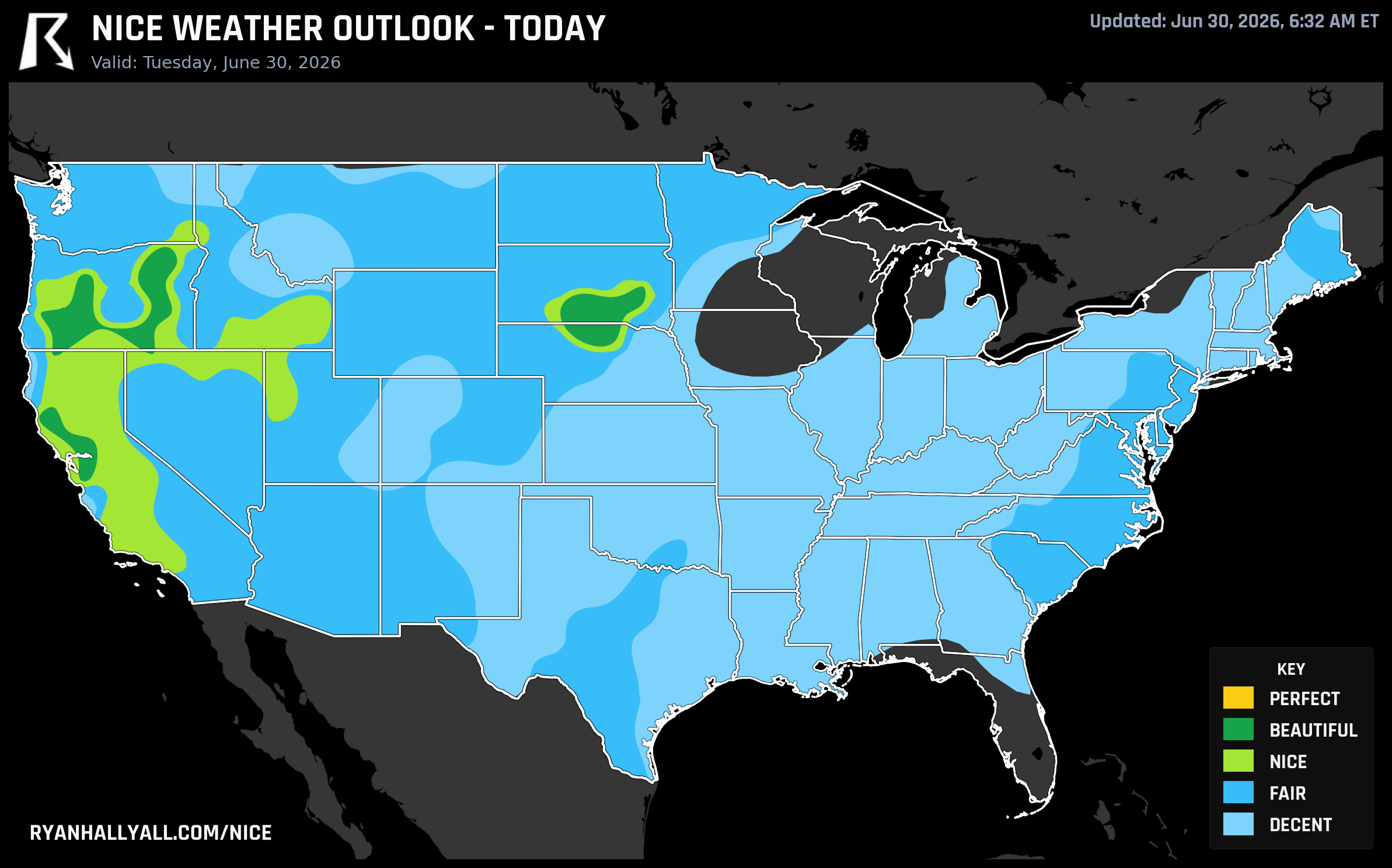
Today, June 30, is the peak of that run. The best scores of the entire seven-day outlook window are sitting right here, right now, across a corridor from the Northern California valleys through Southern Oregon and into the Snake River Plain. After today, scores tick down a notch as the extended pattern shifts, so if you're anywhere in that zone, this is genuinely the day to use.
Today: The Best Day of the Week, and It's Not Close
The top-rated zone today covers the Intermountain West and Pacific Coast corridor, scoring 87.6 out of 100 and landing in the Beautiful category. That's the national high for this entire seven-day period. The numbers behind it are clean: average cloud cover of just 10 percent, a precipitation probability of 2 percent, dewpoints averaging 46°F, and highs around 76°F. That's a patio breakfast kind of morning, a trail run kind of afternoon.
The reason it doesn't reach Perfect comes down to two things. Wind gusts are averaging around 18 mph across the zone, which is pleasant but just enough to keep the wind sub-score at 86.8 out of 100, a hair below the 92-point floor that every sub-score must clear for Perfect. And the UV index is running around 7.8, which technically clears the Perfect gate on its own, but the wind prevents it regardless. Practically speaking, none of that matters much for your afternoon plans. Bring sunscreen regardless.
City-level highlights tell the story well. Medford, Oregon is a standout today: high of 73.5°F, dewpoint of 43°F, 2 percent cloud cover, zero precipitation chance, and an AQI of 41. San Jose, California hits 92 out of 100 with a high of 73°F and dewpoints near 50°F. Sacramento reaches 91°F but stays comfortable thanks to dry air and cloudless skies, also scoring 92. La Grande, Oregon is the coolest entry in the zone at 66°F with a UV index of just 6.1, one of the few spots in the country today where UV wouldn't gate out a Perfect score if the wind cooperated.
And then there's the streak itself. Redding, Shasta Lake, Sacramento, Los Angeles, Stockton, Gilroy, Oakland, Modesto, and dozens of other California cities have now logged 22 consecutive days at or above the Nice threshold. That's the full span of our tracking history, meaning we haven't seen a below-Nice day in that corridor since early June. Discovery Bay and Byron in the Central Valley have been Nice or better every single day of those 22, with both hitting Beautiful on Day 1 today.
The Fourth of July Picture Out West
Here's the honest read on the holiday weekend for the West: conditions stay solidly in the Nice range from Thursday through Sunday, but today is the high-water mark.
On Thursday, July 3, the Pacific Coast and Intermountain West zone scores 79.1 out of 100. Cloud cover is only 16 percent on average, precipitation probability is essentially zero, and dewpoints stay comfortable near 44°F. Los Angeles hits 78°F with a score of 82. San Jose comes in at 79°F. Boise, Idaho joins the list at 82. That's a solid pre-Fourth setup for backyard grilling, trailheads, and outdoor events.
July 4 itself is the second-best day of the holiday run for that corridor, with the zone scoring in the Nice range and Portland, Oregon jumping onto the top-10 list for the first time this week alongside San Diego. Sky cover drops to just 3 percent on average across the best-rated cities, and wind gusts ease to around 14 mph. If you're watching fireworks from the West Coast, the air overhead should be clear.
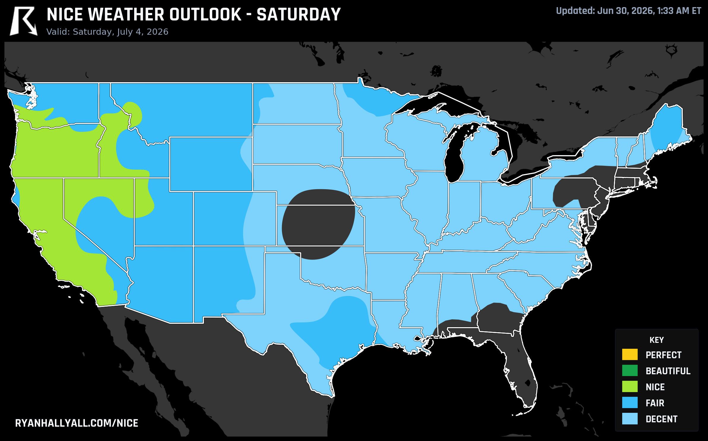
One caveat worth flagging for the Four Corners region: critical fire weather conditions are in effect today and again Wednesday in northeast Arizona, eastern Utah, western Colorado, and northwest New Mexico. The Cottonwood Fire complex in Utah has already burned over 93,000 acres. If you're heading into the backcountry near that zone, check current fire restrictions before you go. That smoke is also nudging AQI readings slightly above 50 in parts of the Intermountain West on Day 2, which is why Wednesday's scores are a notch below today's even though the sky and precipitation numbers are nearly identical.
Where the Rest of the Country Stands
The contrast right now is sharp. East of the Rockies, a major heat wave is building that the WPC is calling significant and record-breaking. Dewpoints are running into the upper 60s and low 70s across the Midwest and Mid-Atlantic, heat indices are pushing into triple digits in places, and severe thunderstorms are in the picture for the northern tier through Wednesday. Chicago is scoring 50.8 today with a dewpoint of 72.8°F and a 43 percent chance of rain. Houston sits at 55.4 with a high near 96°F. Those aren't nice weather numbers.
The one small bright spot east of the Mississippi today is a slice of the southern New Jersey and Delaware coast, where Sicklerville and Salisbury, Maryland are each scoring 82 out of 100 in the Fair category. That's the best the Northeast can do today, and it's worth noting if you're near the shore.
For the full picture of where comfort is concentrated across the country this week, the Nice Weather outlook page has city-by-city scores and regional rankings updated daily.
The Weekly Summary
If you're looking for the single best place in the country to be outdoors this week, the Santa Barbara to Ventura corridor holds the top weekly ranking with a mean score of 86.3 and six out of seven Nice-or-better days. Santa Barbara, Ventura, Carpinteria, and Ojai all cluster at the top of the weekly list. San Jose leads all large cities with a mean score of 83.4 and a Perfect-rated day today.
The pattern that's keeping the West comfortable is the same one that's building heat in the East: an upper-level ridge anchored over the eastern half of the country is keeping that air mass locked in place, while a western trough keeps the Pacific Coast and Intermountain West in a cooler, drier flow. WPC extended forecasts suggest that ridge starts to weaken around Sunday for most of the East, which may bring some relief by early next week. Out West, the CPC's week-two hazards outlook flags a slight risk of episodic high winds for portions of California and the Pacific Northwest from July 7 through 13, so that comfortable pattern won't last forever either.
For now though, if you're in the Sacramento Valley, the Rogue Valley, or the Snake River Plain, today is the day to get outside.