Blog Article
July 4th Nice Weather: Oregon's Willamette Valley Leads the Nation
Portland scores 92/100 on the Fourth of July as the Willamette Valley runs a seven-day streak at the top of the national nice weather rankings. Here's the full outlook.
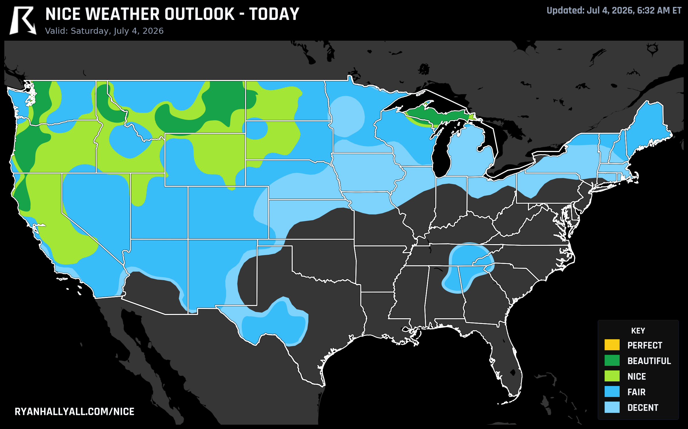
Oregon's Willamette Valley Just Won the Week: Seven Straight Days of Nice Weather
Yesterday, the Mid-Atlantic was under an Enhanced Risk of severe storms. Iowa is still drying out from 12 inches of rain. A major heatwave is building across the South. And the national nice weather map is, frankly, a lot of red and orange.
Then there's a quiet green stripe running down the Willamette Valley, where Lebanon, Oregon just posted a mean score of 86.3 out of 100 across all seven forecast days. Seven days. Every single one of them at or above the Nice threshold. It's the top spot on this week's national leaderboard, and today is the peak.
Today, July 4th: The best day of the run
Portland scores 92/100 today, landing in the Beautiful category. High of 75.2°F, dewpoint of 55.3°F, 1% chance of rain, winds around 11 mph gusting to 16. UV is 7.7, which is worth a sunscreen reminder but clears the Beautiful gate. Salem matches that score at 92/100 with a high of around the same range and similarly dry air. Medford comes in at 92/100 as well, hitting 89.3°F under essentially clear skies with a dewpoint of 51.6°F.
The zone-wide average for the Beautiful tier today is 88.7 out of 100. That's 3.3 points shy of Perfect, and the gap isn't the weather itself. It's the UV index, which averages 7.7 across the zone and needs to be at or below 7 to clear the Perfect gate. The AQI of 43 zone-wide also sits just above the 35-point threshold. The sky is genuinely excellent. The air quality is clean enough that you won't notice it on a trail. But the scoring system is strict, and those two gates are the ceiling.
For fireworks tonight in the Portland-Salem corridor, the forecast is about as clean as July gets west of the Rockies. Light winds, near-zero rain chance, and comfortable temperatures after sunset. If you're planning to watch from a park or a hillside, this is the kind of night you plan around.
Further east, Billings, Montana is also scoring 92/100 today. High of 89.4°F with a dewpoint of just 49.3°F. Dry and warm, not oppressive. The wind is gentle at 8.8 mph. Marquette, Michigan rounds out the Beautiful tier at 92/100 with a high of 69.3°F and a UV of only 7.0, the lowest in the zone.
The week ahead: Oregon holds, the West Coast takes over
The Beautiful scores in the Northwest step down a bit on Sunday, but the Willamette Valley stays in the running. Salem and Eugene both score 92/100 on Day 2, now in the Beautiful category again. The zone-wide Beautiful average on Sunday is 87.0/100, with wind actually the strongest sub-score at 97.6/100. Average gusts across the top Beautiful cities on Sunday are only 14.4 mph. That's a patio-breakfast kind of morning.
By Monday, July 6th, the story shifts south. San Jose jumps to 92/100 and leads the national rankings. San Francisco scores 82/100. Grand Rapids, Michigan and Green Bay both climb into the Beautiful tier as drier air filters into the Great Lakes behind the weekend's frontal passage. The Upper Midwest is going to feel noticeably better by Monday, with dewpoints dropping back into the 50s and low 60s after a rough stretch.
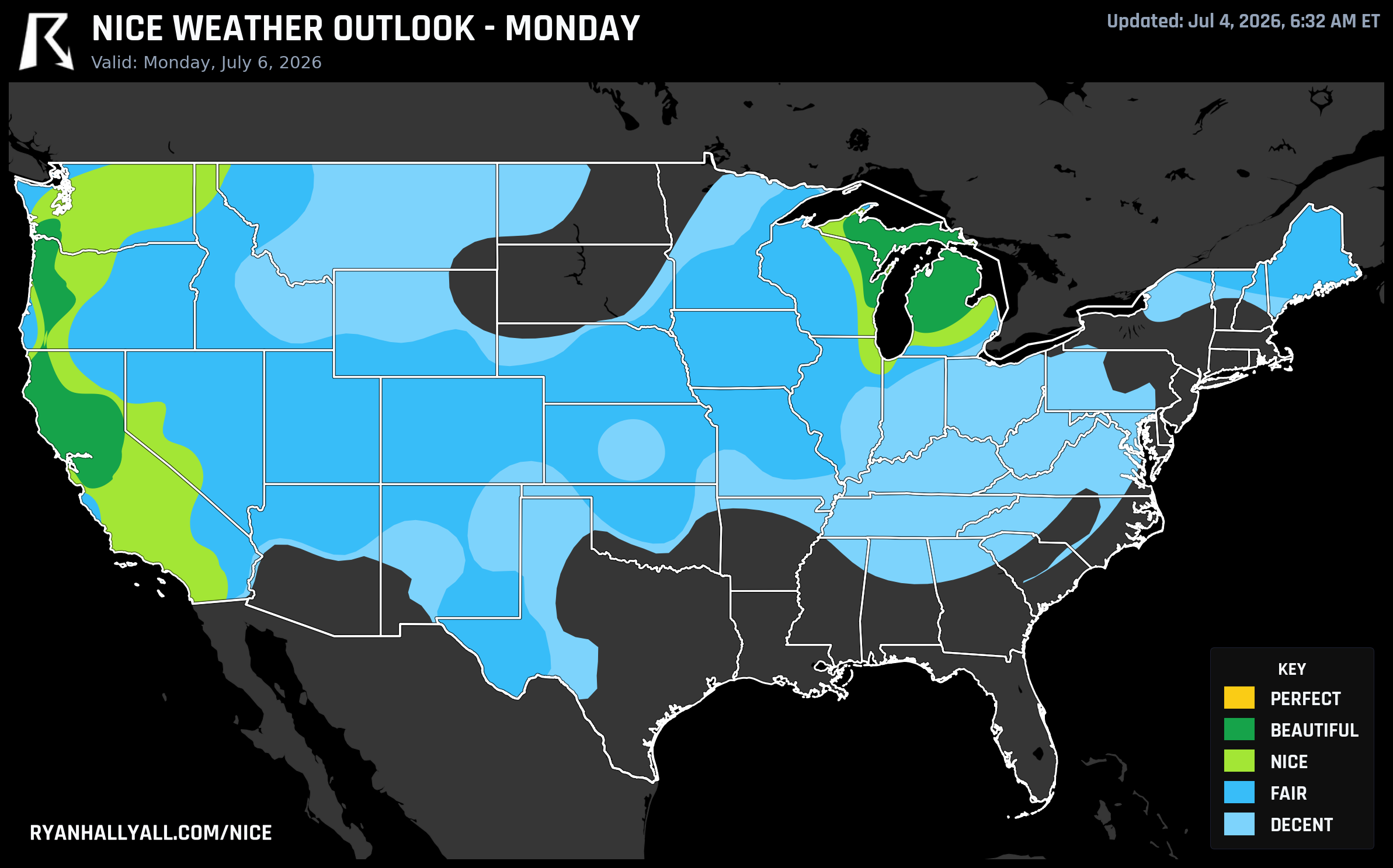
Beyond Day 3, the maps get simpler. A building upper-level ridge anchors the best weather firmly along the West Coast and Intermountain corridor. Los Angeles, San Diego, Portland, and Spokane all show up consistently in the Nice tier through the end of the week. The Great Lakes and Northeast face a different story: recurring storm chances, elevated humidity, and a major heatwave building across the South all keep scores in the Decent to Fair range east of the Rockies for most of the period.
The streak context
The weekly rankings are dominated by small Willamette Valley towns you might not have on your radar. Lebanon, Sweet Home, Veneta, Philomath, Brownsville. All seven days above the Nice threshold. Mean scores of 86.3. These aren't flukes. The valley's geography, sitting between the Coast Range and the Cascades, channels marine air in a way that keeps temperatures moderate and humidity manageable even in early July. Upper-level ridging over the Great Basin has been reinforcing that pattern, keeping storm chances essentially zero across the region for the whole forecast period.
California also has something worth noting: Los Angeles, Sacramento, Redding, and most of the Central Valley have been on a 26-day Nice streak as of today. That's the full extent of the tracking history in the data. They've been nice every single day since at least June 9th.
If you want to dig into how your specific city is scoring through the week, the Nice Weather outlook page has the full breakdown by city and region.
A note on the rest of the country
This isn't the post to fully cover the hazards picture, but it's worth a quick mention for context. The Mid-Atlantic is still in an active pattern through Sunday, with a Slight Risk of excessive rainfall and severe storms. A major heatwave is expected to settle over the South and Southeast next week, with the CPC flagging a moderate risk of extreme heat across the Great Basin, Desert Southwest, and Southern Plains as early as July 12-15. Fire weather concerns remain elevated along the eastern slopes of the Cascades today, where downslope winds could push relative humidity into the 20s.
If you're in the Pacific Northwest or Northern Rockies this holiday weekend, you're in the right place at the right time.