Blog Article
Best Weather Day of the Week: July 5, 2026 Outlook
Sunday July 5 is the peak of a 7-day nice weather outlook, with Seattle, Wausau, and northern Maine scoring Beautiful. Here's what changes starting Monday.
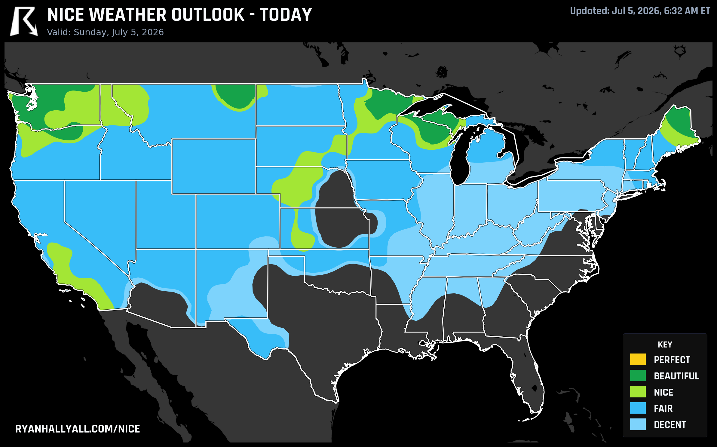
Today Is the Best Day of the Week — The Northwest and Upper Midwest Are at Their Peak
The country had a rough Fourth of July. Iowa was underwater. The Mid-Atlantic was dodging damaging wind gusts. A geomagnetic storm showed up uninvited. And then Sunday arrived, and the northern tier of the country woke up to something genuinely pleasant.
Today, July 5th, is the best single day in the entire 7-day outlook. The data is clear on that. And for folks in the Pacific Northwest, the Upper Great Lakes, and northern New England, this is the window. Starting tomorrow the ceiling starts to drop, and by mid-week the national picture gets complicated fast.
Where it's Beautiful today
The top tier today is Beautiful, with a zone-average score of 88.1 out of 100. That band runs from the Pacific Northwest through the Upper Great Lakes and into northern Maine.
Seattle is the anchor. High of 68.8°F, dewpoint of 53.2°F, UV index 7.3, AQI 37, winds around 11 mph with gusts to 19. Score: 92 out of 100. Tacoma, Bellevue, Kent, Renton, Everett, and Federal Way are all in the same range. This is a proper July day for the Sound — not too warm, not a cloud in sight until late, light breeze off the water. The Blue Jays are in town tonight at T-Mobile Park, and the ballpark weather is as good as it gets in Seattle.
Wausau, Wisconsin reaches 82.3°F with a dewpoint of 61.9°F and still scores 92. That's the warmest entry in the Beautiful zone, and the humidity is still manageable — dewpoints in the low 60s feel comfortable when the sky is mostly clear and winds are light at 7 mph. Marquette, Michigan and Hibbing, Minnesota are also up in the Beautiful tier this morning.
Glasgow, Montana, of all places, scores 92 today: high of 86.7°F, dewpoint 58.3°F, winds 12 mph gusting to 20, AQI 45. That's a textbook northeastern Montana summer afternoon.
In northern Maine, Presque Isle and Houlton are at the Beautiful level too. Dewpoints in the low 50s, highs near 70°F, winds calm enough to barely notice.
What keeps all of this out of Perfect? The UV index is averaging 7.4 across the zone — the Perfect threshold requires UV at 7 or below. Close, but not there. Wear sunscreen if you're spending the afternoon outside.
The Nice zone is bigger than it looks
Below the Beautiful band, a wide Nice zone covers the central Plains, coastal Pacific, and parts of the Upper Midwest — scoring 81.8 out of 100, just two-tenths of a point short of Beautiful. That's not a rounding error worth worrying about. Los Angeles and San Diego are in this tier today, along with Denver, Boston, and Minneapolis.
Southern California is having a genuinely good week overall. The Orange County coast — Oceanside, Carlsbad, Huntington Beach, Newport Beach, Irvine, San Clemente — holds the top spots on the weekly leaderboard with a mean score of 84.9 to 86.3 across all seven forecast days. Every single day this week clears the Nice threshold there. That's a 27-day active streak for much of coastal and inland California, which is the longest running streak in the country right now.
What happens tomorrow and beyond
Monday looks good in a different set of places. The Beautiful zone shifts to the Upper Great Lakes, northern Maine, and parts of California's Central Valley. Milwaukee scores 82 with a 72°F high and barely any clouds. Sacramento and Stockton come in at 82 as well, with highs near 88°F and dewpoints in the low 50s. Eugene, Oregon reaches 92 on Monday — the only city in the Day 2 data to hit that threshold individually, with calm 5-mph winds and 5% cloud cover.
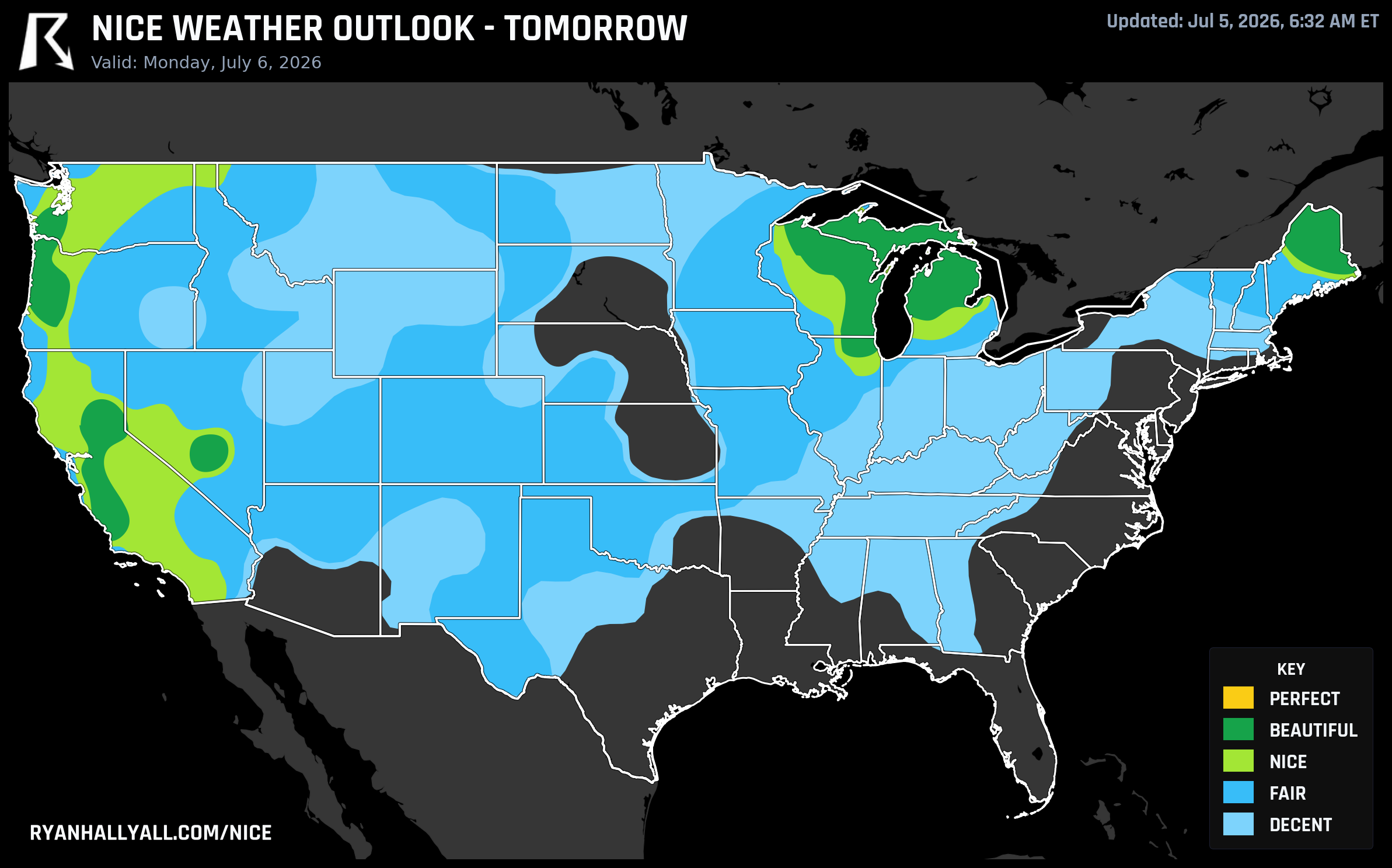
But here's the thing: Monday is still Beautiful territory in the right spots, and Tuesday narrows further to a corridor from coastal Northern California through the Oregon interior valleys. By Wednesday through Saturday, the national ceiling drops to Nice, and a major heatwave is building across the southern tier. The WPC extended discussion is explicit — broad upper-level ridging will support extreme heat from the South into the Southwest and Great Basin through next weekend, while frontal activity keeps the Great Lakes and Northeast unsettled.
For planning purposes, today and tomorrow are your best days east of the Cascades and in the Upper Midwest. Tuesday is your window if you're in the Bay Area or the Oregon interior valleys. After that, the best weather stays concentrated along the Pacific Coast, where the marine layer keeps things from boiling over even as the rest of the country heats up.
The one caveat worth naming
Fire weather. The SPC Day 2 fire weather outlook flags dry thunderstorm concerns across the Pacific Northwest into the Four Corners on Monday, driven by steep mid-level lapse rates and very dry boundary-layer conditions. If you're hiking in northern California, Nevada, Oregon, or Idaho this week, check current fire restrictions before you head out. The nice weather scores reflect outdoor comfort, not fire danger — those are two different things, and they can coexist in the same region.
For the full picture of where the comfortable weather is sitting day by day, the Nice Weather outlook page has the maps and city rankings updated this morning.
Today is the day, y'all. The rest of the week has its moments, but nothing beats what's out there right now across the northern tier. Get outside.