Blog Article
Best Weather July 11: Great Lakes and Upstate NY Shine
Milwaukee, Grand Rapids, Albany, and Rockford score 92 out of 100 today. Here's where the nicest weather is Saturday and what the week ahead looks like.
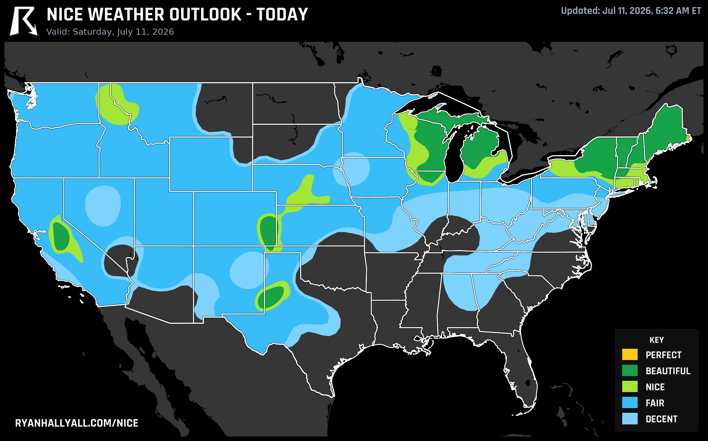
Saturday Delivered: The Great Lakes and Upstate New York Are Having Their Best Day of the Summer
Yesterday's nice weather post called this one. Saturday, July 11, was circled on the map, and the data came through. A Canadian high sitting near 1020 to 1023 mb is running the table across the Upper Midwest and Northeast today, and the numbers it's producing are as clean as mid-July gets in this part of the country.
What Today Actually Looks Like
The Beautiful zone today covers the Great Lakes and stretches into the Northeast, with a zone average score of 87.8 out of 100. Cloud cover is averaging just 9 percent across the top tier. Precipitation probability averages 2 percent. Winds are light, around 9 mph with gusts to 15 mph. Dewpoints in the mid-to-upper 50s keep the air feeling genuinely comfortable rather than sticky.
City-level highlights:
- Milwaukee, WI scores 92.0. High of 77.5°F, dewpoint 62.3°F, 12% clouds, zero rain chance. If you are at American Family Field this afternoon watching the Brewers play in Pittsburgh, the folks back home in Milwaukee are sitting in better weather than the ballpark crowd.
- Grand Rapids, MI also scores 92.0. Highs in the mid-80s, dewpoints in the upper 50s, clear skies.
- Rockford, IL matches that 92.0, though at 84°F it's the warmest of the top scorers. Still very comfortable for an outdoor morning.
- Albany, NY scores 92.0 with a high of around 79°F and dewpoints in the upper 50s. A patio breakfast in the Capital Region today is a good call.
- Syracuse, NY scores 82.0 with a high of 78.8°F and only 8% cloud cover. A gust to 20 mph is the one mild caveat, but nothing that ruins an afternoon.
One honest note: UV index across the Beautiful zone averages 7.3, which sits right at the upper edge of comfortable. That's not alarming, but it's enough to warrant sunscreen for anyone spending a few hours outside. Two variables, dewpoint and UV, are what's keeping this zone from tipping into Perfect, and neither one is a problem in practical terms. It's just a very good day, not a once-in-a-decade day.
There is also a Renaissance Festival running today in Sterling, NY, and a music festival up in Manchester Center, VT. The Sterling area is sitting in Beautiful conditions. Manchester Center is on the southern edge of the nice zone, so conditions are good but worth watching for any afternoon cloud buildup.
Sunday Stays Nice, But the Story Shifts West
Sunday, July 12, the Canadian high slides east and the Pacific Northwest steps up. Portland, OR scores 92.0. Tacoma, WA scores 82.0. Buffalo, NY and Syracuse, NY hold Beautiful ratings on the East Coast, and Rockford, IL stays in the mix. The zone score for Sunday's Beautiful tier is 91.4 out of 100, with dewpoints averaging 53°F and winds barely reaching 7 mph. It's genuinely lovely across the northern tier.
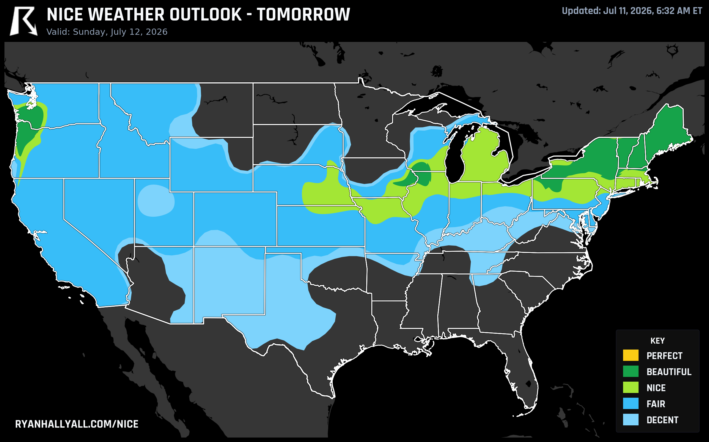
One caveat for Sunday: UV index averages 7.4, just above the threshold that would push this to Perfect. Still very manageable for a full day outside. And for Buffalo specifically, AQI edges to 55, which is just above the Beautiful ceiling of 50. Not a concern for most people, but worth noting for anyone with respiratory sensitivities.
The Week Ahead: Good News Is Mostly in the West
Monday, July 13, the Pacific Northwest takes full ownership of the best-weather crown. Seattle scores 92.0 with a high of 76.5°F, a 46°F dewpoint, and essentially no clouds. Bellingham, Longview, and Olympia all match that. The Northeast still holds Nice ratings on Monday, with Philadelphia, Manhattan, and Baltimore all scoring 72.0 under a Canadian airmass, but clouds are building and the heat dome is beginning to reassert itself east of the Rockies.
From Tuesday onward, a broad upper-level ridge anchored over the northern High Plains takes over the central and eastern CONUS. The WPC is flagging dangerous heat continuing through next week. The best outdoor weather from Days 4 through 7 is capped at Nice by forecast-day confidence rules, and it stays concentrated along the Pacific Coast and Intermountain West. San Jose and Seattle hold Nice ratings all week. The Willamette Valley corridor, including Beaverton, Salem, and Eugene, posts the best weekly averages in the country, averaging 84.9 out of 100 across all seven days with every day rating at least Nice.
For the rest of the country, the picture gets genuinely difficult. Heat stress is flagging 17 to 31 percent of gridpoints in the central zones as too hot to rate at all, and that fraction grows as the week progresses. Brooklyn's AQI hits 122 on Tuesday, which is in the unhealthy for sensitive groups range. If you are planning outdoor events in the Mid-Atlantic or Midwest later next week, keep a close eye on the heat and air quality.
One event worth flagging: the MLB All-Star Game lands in Philadelphia on July 14. The Day 4 outlook for the Philadelphia area puts it in Fair to Nice territory, with highs in the mid-to-upper 80s and dewpoints creeping into the low 60s. Not oppressive, but not the comfortable 77°F of Milwaukee today either. It's a workable outdoor evening, but the heat will be noticeable by first pitch.
The Takeaway
Today is the best single day of the next seven for a very large piece of the country east of the Rockies. If you are in Wisconsin, Michigan, upstate New York, or northern New England and you have been waiting for a genuinely nice summer Saturday, this is it. Get outside.
For the full picture across all seven days, check the Nice Weather outlook page to see which areas hold up best through the week.
The Pacific Northwest is your reliable answer from Monday forward. The rest of the country will be looking at a heat-dominated pattern that makes today's Great Lakes weather feel like a short but very welcome break.