Blog Article
Beautiful Weather Today: Northeast and Pacific Northwest Shine
Today is the last Beautiful-category day for most of the country. Boston, Grand Rapids, Portland, and Eugene score 92 out of 100 before heat takes over mid-week.
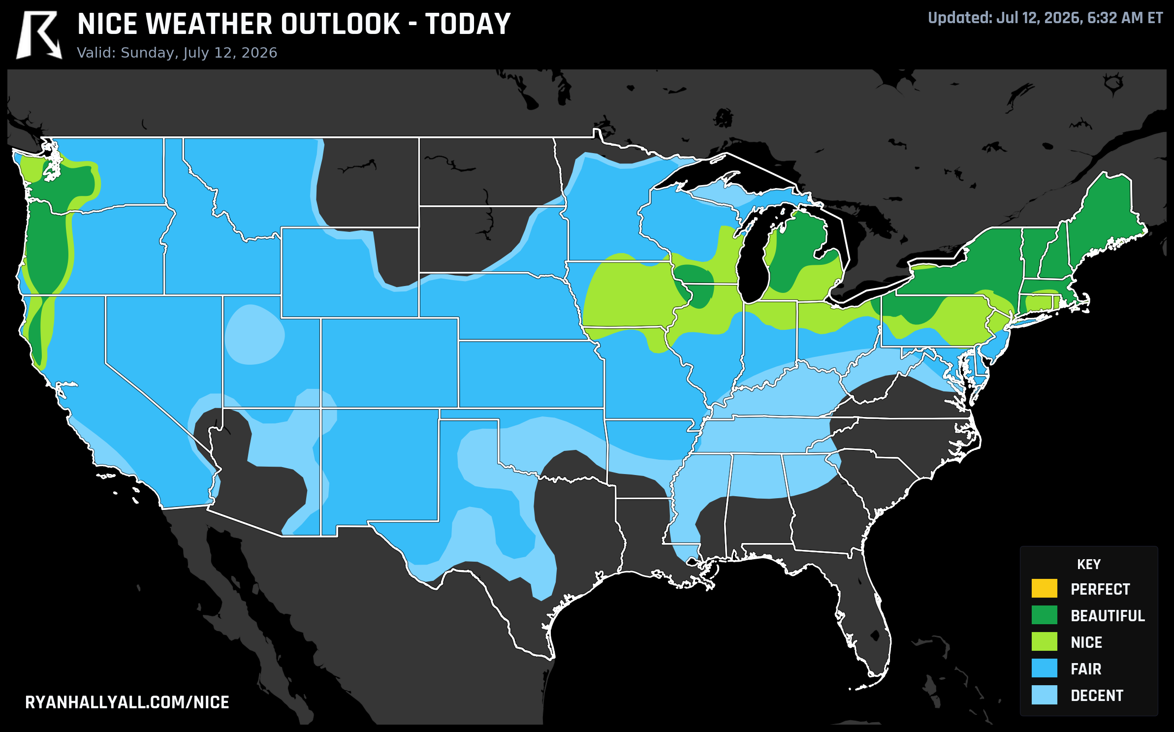
One Last Beautiful Sunday Before the Heat Takes Over
Yesterday's nice weather post nailed it: Sunday was circled on the map. Today is that Sunday, and the data is holding up its end of the deal.
Across the northern tier, from the Great Lakes through New England and out to the Pacific Northwest, today is a Beautiful day by any reasonable measure. The top zone is averaging a score of 90.2 out of 100, with dewpoints sitting around 53°F, winds barely hitting 8 mph, 1 percent precipitation probability, and 14 percent average cloud cover. That's mid-July at its most cooperative.
It's also the last day this looks like this for most of the country east of the Cascades. So let's make use of it.
Today's Best Weather, City by City
Boston comes in at a score of 92, with a high of about 77°F, a dewpoint of 59°F, and only 9 percent cloud cover. If you're going to the Red Sox game at Citi Field today, the weather is not your problem. Grand Rapids scores 92 as well, with that western Michigan lake influence keeping things just a touch more comfortable than the rest of the region. Portland, OR, and Eugene, OR, are both at 92, with dewpoints in the low 50s and nearly clear skies.
Madison, WI, sits at the floor of the Beautiful category at 82, held back by a dewpoint of 64°F, which is the warmest in the zone. Still a fine day for the farmers market or a bike trail, just a little muggier than Boston or Portland.
One caveat worth knowing: Canadian wildfire smoke is filtering into the Northeast today. The zone's average AQI is 41, which clears the Beautiful threshold, but a few spots like New Wilmington, PA, are bumping against 53. You probably won't notice it much at ground level, but it's nudging UV indices up to around 7.5 across the zone, which is enough to warrant sunscreen for extended time outside. It's also the one thing keeping this day from reaching Perfect, which requires UV at or below 7 and AQI at or below 35.
The Ballpark Angle
There are a lot of outdoor games today. The Brewers are in Pittsburgh, the Royals are in Baltimore, the Yankees are in Washington, and the Phillies are in Detroit. Of those, Detroit (Beautiful zone, Grand Rapids just to the west) and Pittsburgh (close enough to the northern tier to benefit) are your best bets for genuinely comfortable late-afternoon baseball. Baltimore is borderline, sitting in the Nice category as dewpoints start climbing toward 60°F. Washington is similar. If you're heading to any of those parks, afternoon temps in the mid-to-upper 80s with manageable humidity are the forecast. Bring sunscreen.
Tomorrow Holds for the Pacific Northwest
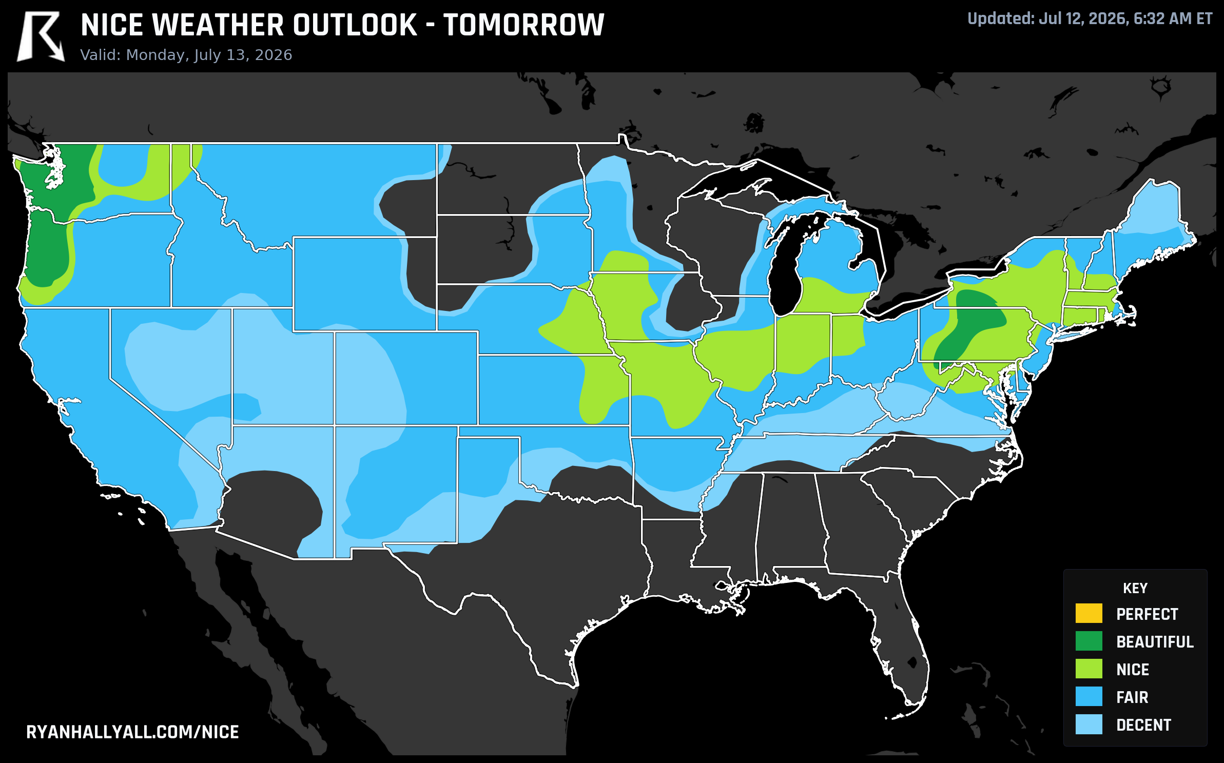
Monday, July 13, the Beautiful zone contracts sharply. The Pacific Northwest takes the lead, with Seattle scoring 92, Portland at 92, and the entire Puget Sound corridor through Bellingham and Olympia looking excellent. Zone averages show a high of 77°F, dewpoints of 54°F, 9 percent cloud cover, and nearly zero precipitation chance. It's a legitimately great day to be in western Washington or Oregon.
Altoona, PA, holds on at 92 as well on Monday, making it the lone eastern anchor of the Beautiful zone. Philadelphia drops to Nice. Indianapolis stays Nice. Most of the Midwest starts its slide into heat and humidity as dewpoints climb into the 60s and the ridge builds.
For the Pacific Northwest, Tuesday, July 14, is actually the cleanest day of the three. Portland, Eugene, and Olympia all score 92, with dewpoints averaging 49°F and cloud cover dropping to just 3 percent. The upper-level ridge rebuilding over the region drives that. Olympia peaks at 79°F with zero precipitation chance, which is about as comfortable as mid-July gets anywhere in the country. Note that Grants Pass reaches nearly 98°F on Tuesday, which is a reminder that the inland valleys of southern Oregon are playing by different rules than the coast and Willamette Valley.
The Rest of the Week Is a Pacific Coast Story
From Wednesday onward, the ceiling drops to Nice across the whole country, and it's achievable only along the California coast and, by Friday and Saturday, a broader corridor stretching into the inland Pacific Northwest and northern Intermountain West. San Jose and San Francisco hold Nice scores through Thursday. Eugene keeps Nice scores all seven days of the outlook, making it the top-ranked city in the weekly standings with a mean score of 86.3 and Beautiful or better on the early days.
For the rest of the country, the WPC extended discussion is not encouraging. A strong upper-level ridge stretches from the Intermountain West through the Midwest toward the Mid-Atlantic, and Major to Extreme HeatRisk is expected to persist across the Dakotas into the Midwest. Dewpoints across the Central and Eastern U.S. will be deep into the 60s and 70s, which means outdoor comfort scores stay suppressed regardless of sunshine or rain chances.
If you're planning anything outdoors east of the Rockies for the coming week, today is genuinely the last good window for a while. Get the Nice Weather outlook page bookmarked for when the pattern finally breaks.
The Oregon Willamette Valley Is Having a Week
One thing worth calling out from the weekly rankings: the Willamette Valley corridor is dominating. Eugene, Springfield, Corvallis, Albany, Roseburg, and about twenty other Oregon cities all score a mean of 86.3 over the full seven-day outlook, each with Beautiful or better on Day 1. That's not a fluke. It reflects a genuine synoptic setup where the Pacific Northwest sits under comfortable high pressure while the rest of the country bakes. If you've been thinking about a trip out that way, the next few days are the sweet spot before inland valley heat starts building late in the week.