Blog Article
Northeast Storms Clear Out, Monday Brings the Week's Best Weather
Severe storms exit the Northeast tonight, then Monday turns into the nicest air of the week. Plus why the Pacific Northwest and California's Central Coast keep winning.
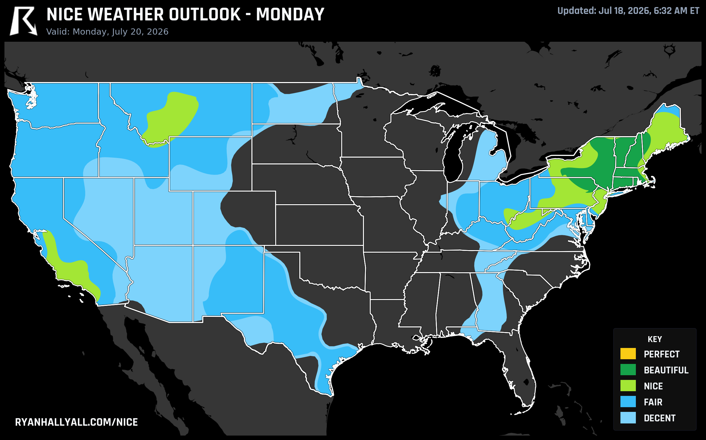
Storms Clear the I-95 Corridor Tonight, Then Monday Turns Into the Nicest Day the Northeast Has Seen in Weeks
If you're in the Northeast or Mid-Atlantic tonight, you already know this isn't a nice weather day. Storm Prediction Center has an Enhanced Risk of severe thunderstorms up for a stretch that covers New York, Philadelphia, Washington, and Baltimore, damaging wind gusts and a couple of tornadoes possible as a strong upper trough rides through. Folks at the Levitate Music & Arts Festival in Marshfield, Massachusetts are dealing with that same system this evening. It's not fun, but it's also not the whole story for the week.
Because once that front clears out, the payoff shows up fast. By Monday, the interior Northeast and Mid-Atlantic become the best weather in the country, and it isn't close.
Tonight and tomorrow, the Pacific Northwest still owns the ceiling
Today's map looks a lot like it has most of this month: Seattle, Salem, Eugene, Bellingham, Olympia, and Longview all sit at 92 out of 100, solidly in the Beautiful tier, with dewpoints in the low-to-mid 50s and skies at 1 to 15 percent cloud cover. That holds through Sunday too, with Portland and Pueblo, Colorado joining the leaderboard as the ridge shifts slightly.
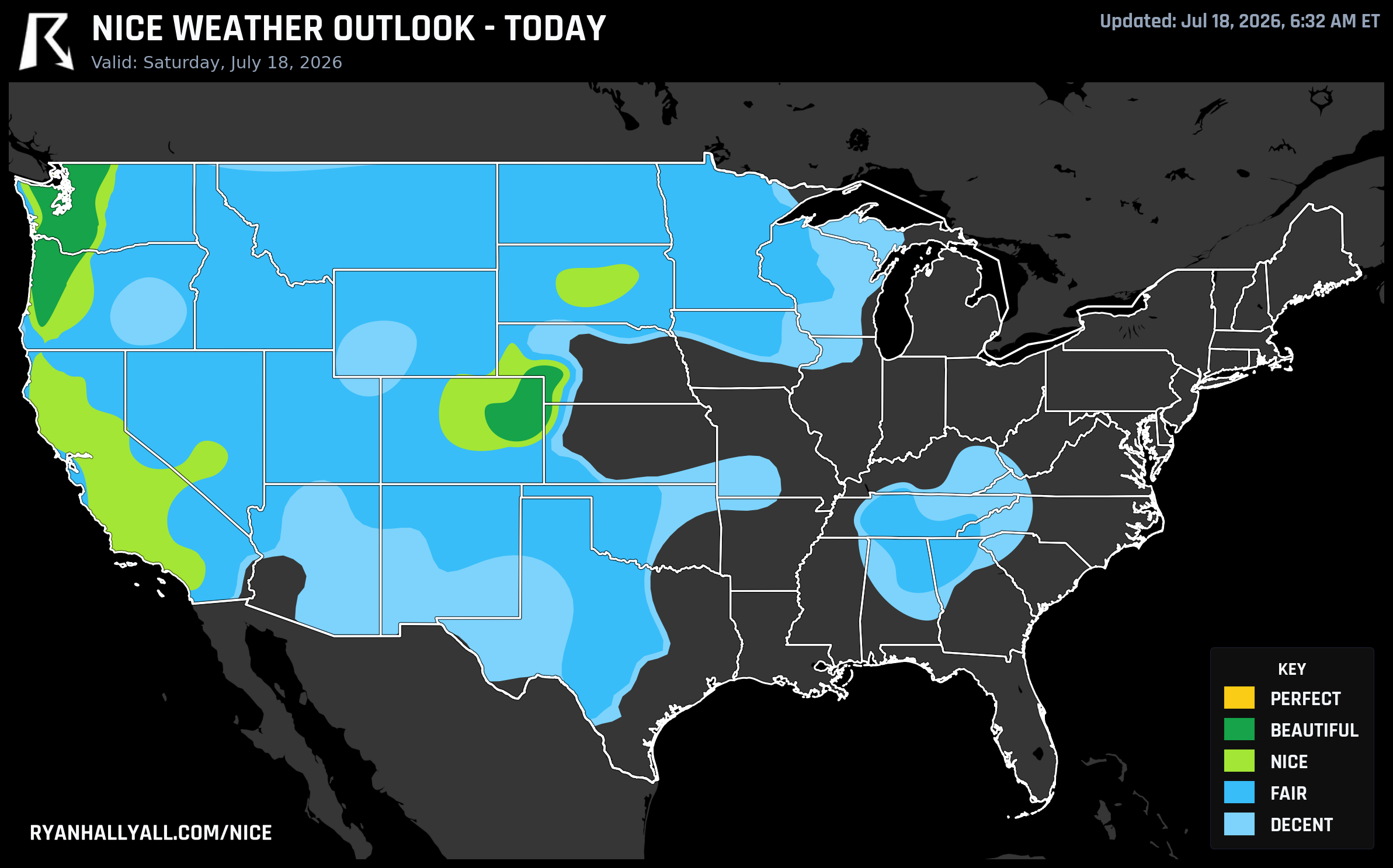
Here's the honest caveat, though: this zone is topping out at Beautiful, not Perfect, and it isn't the raw numbers holding it back. Precipitation and dewpoint scores are basically maxed out. It's UV running 7.7 to 8.4 and background AQI in the 40s and 50s that trip the stricter gates Perfect requires. Sunscreen is still worth packing for that Sunday patio breakfast in Eugene. There's also a fire weather angle worth knowing about if you're headed to a Cascades trailhead: gusty west-southwesterly winds and 10 to 15 percent relative humidity are keeping elevated fire weather concerns in play even under those clear skies.
Monday's the real headline
A large area of high pressure and dry northwest flow settles over the Northeast and Mid-Atlantic behind tonight's front, and the turnaround is dramatic. Worcester, Springfield, Bridgeport, Manchester, Albany, New Bedford, Scranton, Binghamton, Burlington, and Norwich all land in the Beautiful tier Monday, with dewpoints in the mid-50s, essentially rain-free skies, and overnight lows dropping into the 50s. That's the kind of air that makes a Monday morning school pickup feel like a gift, jacket weather at sunrise and a genuinely pleasant afternoon by lunch.
The sub-scores back it up: precipitation and dewpoint are both sitting near 95 to 98 out of 100 in that zone, and heat stress is a non-issue. Sky cover and wind knock a few points off here and there, Philadelphia's still carrying an AQI of 71, high enough to keep it out of the very top tier even though it's well clear of any health concern, but this is as clean a setup as the East Coast has had in a while. Worth noting: this is capped at Beautiful by the forecast-day rules for Day 3, not by the weather itself, which genuinely earns a higher grade on the underlying numbers.
Elsewhere Monday, the pattern is less kind. The central Plains and Midwest stay warm and humid, with dewpoints near 70 and highs pushing 90 to 98, and a severe storm and gusty wind risk keeps one Plains zone capped at Decent no matter how the other numbers look.
The California list nobody's been talking about
While the Pacific Northwest keeps grabbing headlines, a quieter story has been building on the weekly leaderboard. Los Olivos, Nipomo, Vandenberg Village, Orcutt, Solvang, Buellton, Santa Ynez, Paso Robles, Templeton, and San Luis Obispo, all Central Coast wine country towns most people outside California couldn't place on a map, have logged all seven days of this outlook at Nice tier or better, with a mean score above 81 and a best-day score of 92 landing on Monday. It's the same marine-influenced pattern that keeps the coast comfortable while inland California bakes.
And speaking of inland California, Redding, Shasta Lake, Sacramento, and a run of Central Valley cities are all sitting on 40-day live streaks at the Fair tier or better, which is a genuinely impressive stretch given how hot that valley runs in July. The trick is dry air: the heat is real, but low humidity keeps it from crossing into the kind of heat stress that would knock these cities out of the outlook entirely.
What to actually do with this
If you've got flexible travel or outdoor plans in the Northeast, Monday is the day to grab, not this weekend. Farmers markets, trail runs, ballpark weather, all of it should feel noticeably better than it has in weeks. The Pacific Northwest remains the safest bet through Sunday if you're already there, just carry sunscreen and check local fire restrictions before you head into the woods. And if you're chasing consistency over a single great day, the Central Coast of California and the Central Valley's dry-heat streak are both worth a look on the Nice Weather outlook page.
Heat is still the dominant story almost everywhere outside these pockets. CPC's week-two outlook flags a moderate risk of extreme heat building across the Southern and Central Plains and Desert Southwest by next weekend, so enjoy these comfortable stretches while they're on the map. They tend not to sit still for long.