Blog Article
Nice Weather Today: PNW's Beautiful Air vs CA's 41-Day Streak
Portland and Salem own today's Beautiful-tier ceiling while California's Central Valley rides a 41-day Nice-weather streak despite real heat. Full outlook inside.
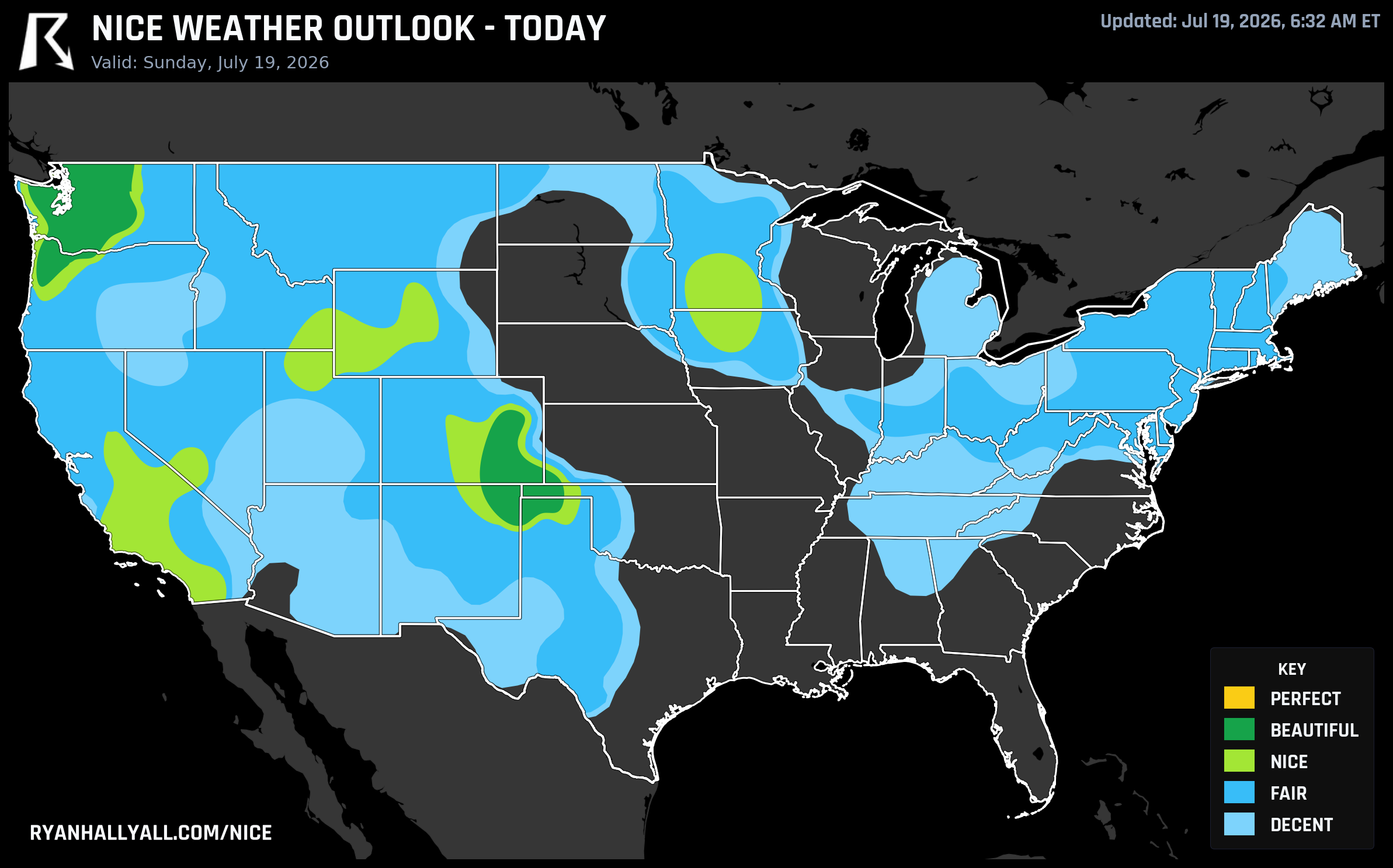
Portland Takes Today's Crown, But California's Interior Has Quietly Strung Together 41 Nice Days in a Row
If you want the best patio breakfast in the country today, get yourself to the Willamette Valley. Portland and Salem are sitting at 92.0 on our 0-100 scale, the top score anywhere in the nation right now, with Vancouver, Yakima, Bellingham, and Olympia riding right alongside them. Dewpoints in the low 50s, only 14 percent cloud cover, and practically no rain chance make this the day's only true Beautiful-tier zone, stretching from the Willamette Valley through the Puget Sound lowlands and into the central Rockies around Pueblo, Colorado.
It's not quite Perfect, and the data explains exactly why. Wind is running about 11.5 mph zone-wide, just over the 92-point threshold Perfect requires, UV is sitting at 7.9 against a cap of 7, and heat-stress scores are still shy of the mark even with highs only in the low 80s. Small gaps, but real ones. Elsewhere, smoke drifting down from Ontario's wildfires and a stiff 10-17 mph wind field are keeping most of the rest of the country stuck in Fair or Decent territory today, even in spots that are otherwise warm and dry.
The story nobody's been telling: California's 41-day run
While Portland grabs today's headline, our streak tracking turned up something that's been building quietly since early June. Redding, Shasta Lake, Sacramento, Stockton, Modesto, Elk Grove, Roseville, Oakland, Hayward, Concord, Visalia, Lancaster, Palmdale, Gilroy, and Sierra foothill towns like Shaver Lake and Sunnyside-Tahoe City have all been sitting at Fair category or better every single day since June 9. That's 41 days in a row, the longest live streaks in the country.
Here's the catch, and it's worth being honest about: this isn't 41 days of cool comfort. It's 41 days of dry heat that the scoring system rewards because rain, cloud cover, and dewpoint stay excellent even as the thermometer climbs into the 90s and low 100s across the Central Valley. Our own Day 4 zone data makes the point directly: Sacramento's surrounding zone reads as Nice on the composite, but Sacramento's own forecast high of 101.8°F blows right past the zone average. A handful of these cities did spike into Beautiful territory back on June 21, but the baseline reality most days is a dry heat that still calls for shade, water, and sunscreen even while the sky-and-rain math says things are pleasant. If you're out in Sacramento, Stockton, or Modesto this week, treat the streak as a compliment to the air quality and sky, not a green light to skip the hydration.
The Central Coast and Sierra foothills are the week's real winners
Zoom out to the full seven-day picture and the top of our weekly leaderboard belongs to a cluster you don't hear about much: Santa Ynez, Solvang, Goleta, Los Olivos, and Templeton up in Santa Barbara wine country, plus San Clemente and San Juan Capistrano down in Orange County, and a run of Sierra foothill towns like Twain Harte, Arnold, Pioneer, and Mi-Wuk Village. Santa Ynez leads the whole country with a 83.4 mean score across the week and six Nice-or-better days out of seven. These towns get the best of both worlds, marine-tempered air along the coast and dry, high-elevation comfort in the foothills, without the valley heat that keeps dragging Sacramento's numbers down.
Looking ahead: a gorgeous Monday, then the front turns rowdy
Tomorrow, the ceiling shifts east. A fresh high pressure system and a drying cold front set up a Beautiful-tier zone from the central Great Lakes into the Ohio Valley and Northeast, scoring 90.5 out of 100, with dewpoints falling into the 50s in Worcester, Providence, Springfield, and Albany. It's a legitimately great outdoor day, held back from Perfect only by a heat index nudging 96°F and UV around 7.7.
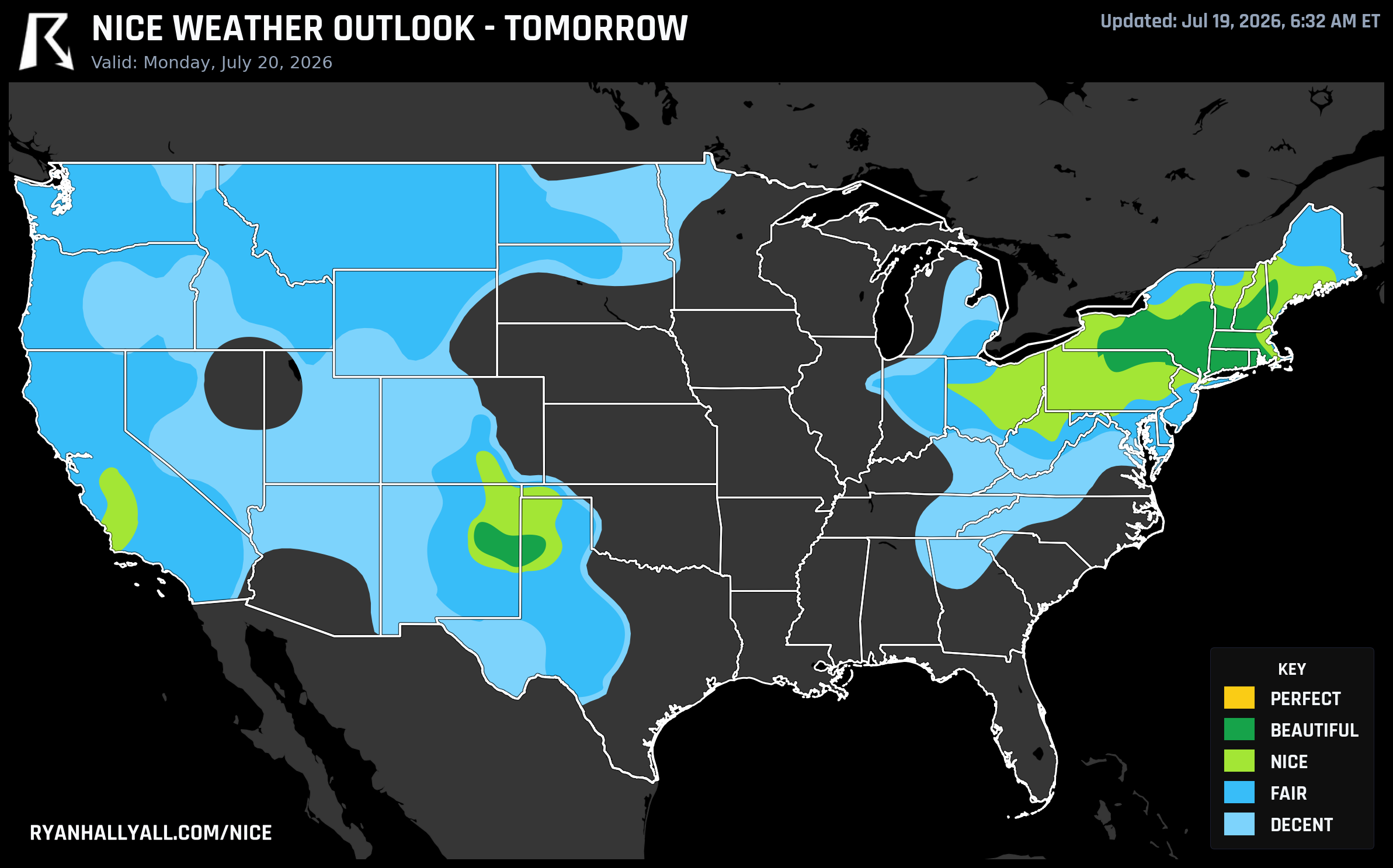
But here's the nuance worth flagging before you make weekend plans: the same frontal system delivering that gorgeous Monday air is also the trigger for an Enhanced Risk of severe storms across Wisconsin, Iowa, and the Upper Midwest that same day, and the risk zone slides into the Ohio Valley itself by Tuesday, with Lexington, Cincinnati, and Pittsburgh under an Enhanced Risk for damaging wind gusts and hail. So enjoy the calm air while it's overhead, because the front responsible for it doesn't stay quiet everywhere it goes.
One more overlap worth mentioning: EAA AirVenture Oshkosh kicks off Monday in Wisconsin, sitting right at the edge of that same Great Lakes air mass. Fliers should get a solid start to the week before any Tuesday storm energy has a chance to build in.
The caveats that matter this week
Air quality is the recurring asterisk on this outlook. Canadian wildfire smoke is still drifting into the Great Lakes and Midwest, with Air Quality Alerts posted from Minneapolis to Cleveland, and interior Pacific Northwest locations are dealing with their own smoke from regional fires. Heat stress is also building nationally as we move into next week, with the Climate Prediction Center flagging an elevated risk of extreme heat returning to the Plains, Desert Southwest, and California Valley by late July. If your outdoor plans stretch beyond this weekend, keep an eye on both AQI and heat advisories, not just the rain forecast.
For the full seven-day picture, city-by-city scores, and where the next Beautiful or Perfect tier is likely to show up, check the Nice Weather outlook page.