Blog Article
Nice Weather Today: Clovis NM Tops US, CA Corridor Wins the Week
Clovis, NM has the best weather score in the US today, while a California corridor near San Jose dominates the week and Philadelphia flips from storms to Beautiful by Thursday.
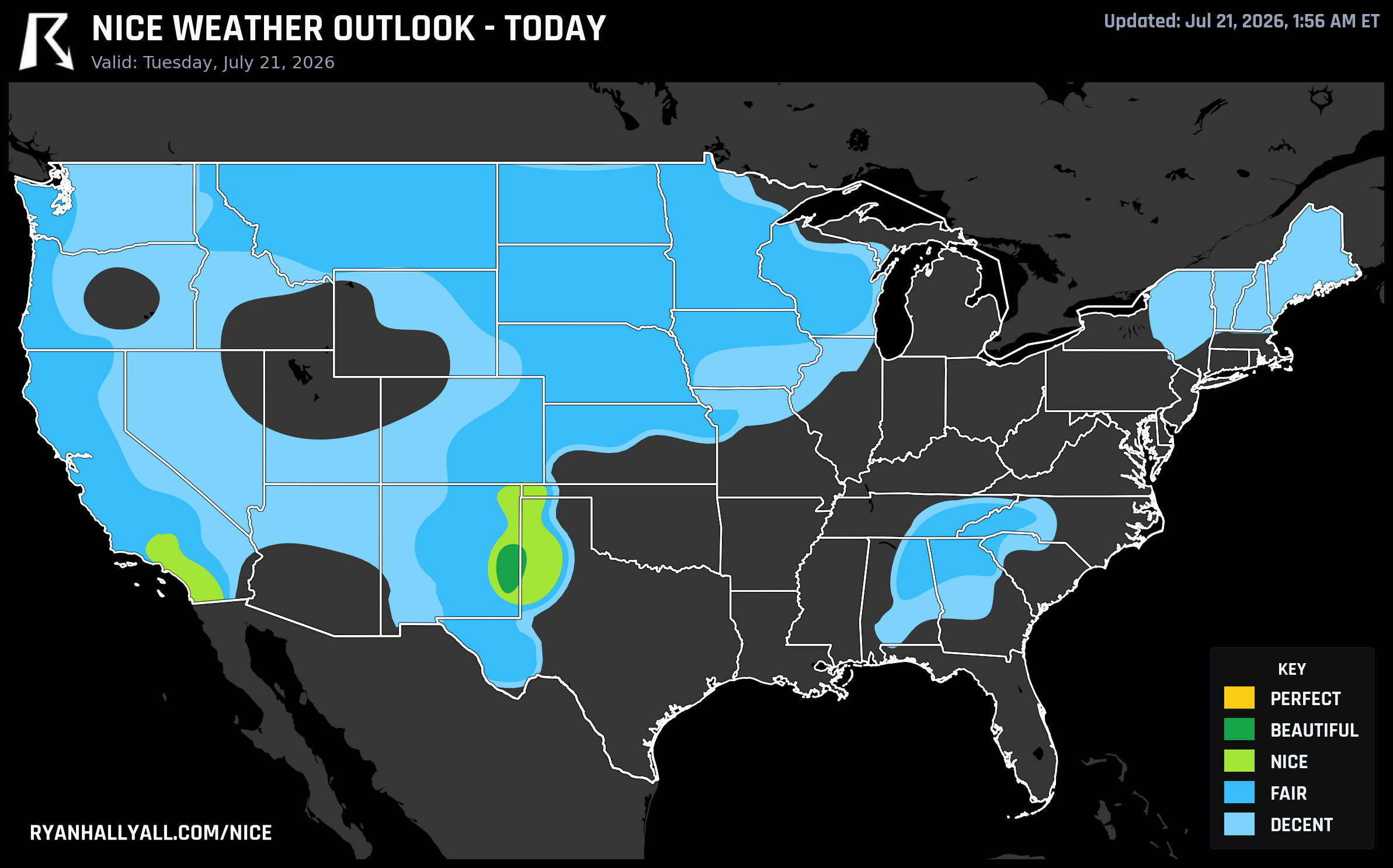
Clovis Takes the Crown Today, But a Quiet California Corridor Is Winning the Whole Week
Some days the nice weather map has one clear headline. Today it's a narrow stripe along the New Mexico/Texas border, but the more interesting story this week might be happening a couple thousand miles west, where a cluster of California towns just will not stop showing up at the top of the leaderboard.
Today's Best Air Sits Near Clovis
If you're anywhere near Clovis, Portales, Tatum, or Bovina today, you drew the day's best card. That zone posted a score of 88.5, the top mark in the country, on essentially cloudless skies, dry air with dewpoints near 61.7°F, and only a light 14 mph breeze. It's warm, highs near 94°F, but it's the kind of dry warmth that doesn't beat you down.
It won't quite reach Perfect, and not because of anything wrong with the air mass itself. UV is running 8.7 and AQI sits at 44, and both just miss Perfect's stricter gates (UV of 7 or less, AQI of 35 or less). So bring sunscreen, but otherwise this is about as good as July gets on the Plains.
El Paso is riding a similar reprieve, running 5 to 10 degrees below average, which lines up nicely with tonight's Plaza Classic Film Festival screenings downtown. Outdoor moviegoers should still watch the midday sun, but evening conditions look comfortable.
One basin over, Los Angeles, San Diego, and Riverside are all sitting in Nice territory today too, carried by clear skies and comfortable dewpoints, though Long Beach's AQI of 65 is a reminder that coastal haze can still take a bite out of an otherwise pleasant beach day.
The Real Story Is a Quiet California Streak
Here's the thing that jumps out when you zoom out to the full week. Twenty of the top 25 cities in the entire country, ranked by average score across all seven days, are packed into a tight radius around San Jose, Santa Rosa, Napa, Watsonville, and the Central Coast. Morgan Hill, Communications Hill, Cambrian Park, Los Gatos, Campbell, Brentwood, and San Jose itself all show up, and every single one of them posted a Fair-or-better score on all seven days we're tracking. That's not a lucky afternoon. That's a whole week of marine layer mornings, dry Pacific air, and afternoon highs that never get ugly.
Zoom out a little farther and it gets even more remarkable. Redding, Shasta Lake, Sacramento, Stockton, Modesto, Oakland, Berkeley, and a long list of other Central Valley and Bay Area cities are now sitting on a 43 day streak at Fair or better, one more day than where that streak stood yesterday. That's more than six weeks of consistently decent to beautiful weather for a huge stretch of California, even while the rest of the country has been dealing with tornadoes in Iowa, flash flooding in the Southeast, and a tropical storm bearing down on Louisiana.
For the Nice Weather outlook page, this is the kind of stretch worth bookmarking if you're planning a Bay Area trip. The marine layer keeps mornings mild and dewpoints in the 50s keep afternoons from turning sticky, which is a rare combination for late July anywhere in the country.
Philadelphia's Whiplash Week
This is also a good week to talk about timing, because Philadelphia is living two completely different forecasts within 48 hours of each other. Tonight, the city sits inside an SPC Enhanced Risk for severe thunderstorms, with widespread damaging wind gusts possible as a cold front works through, right as the Dodgers and Phillies play ball there. Not the night for a rooftop deck.
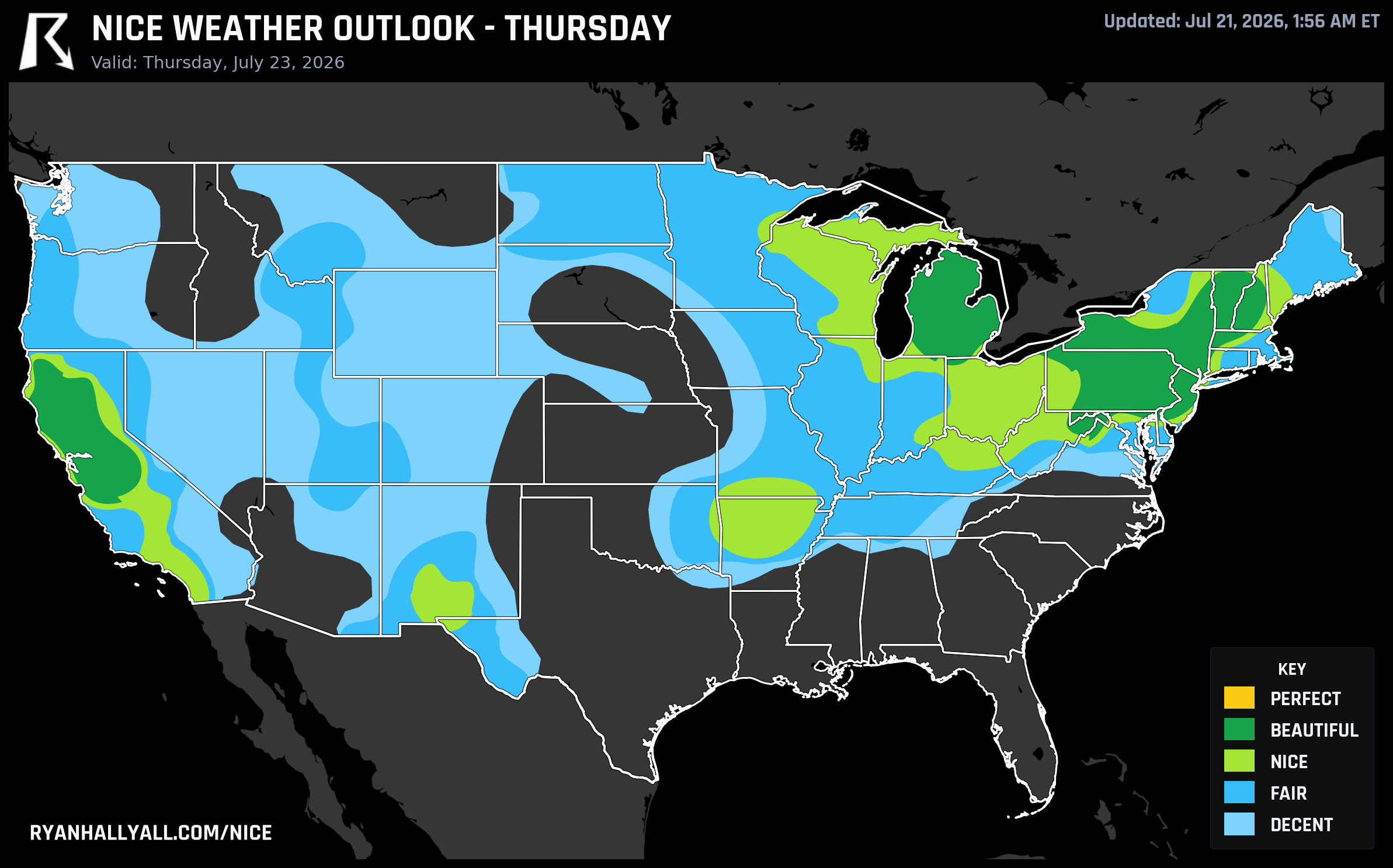
By Thursday, the picture flips entirely. Once that front clears out and drier, cooler air settles in behind it, Philadelphia posts a 92.0, the best score of any major city in the country that day, in the Beautiful tier with dewpoints down near 56°F and skies essentially clear. Buffalo, Grand Rapids, and San Jose all ride the same crisp air mass to similarly strong scores. It's a useful reminder that one rough evening doesn't tell you much about the rest of the week, and that the same storm systems clearing the air can set up some of the nicest days that follow.
Looking a bit farther out, if you've got the Newport Folk Festival on your calendar for July 24, that event sits right on the edge of this same clearing pattern moving into the Northeast. Confidence four days out is lower than for Thursday, but the early signal favors comfortable, drier air holding across New England into the weekend.
Where the Good Weather Heads Next
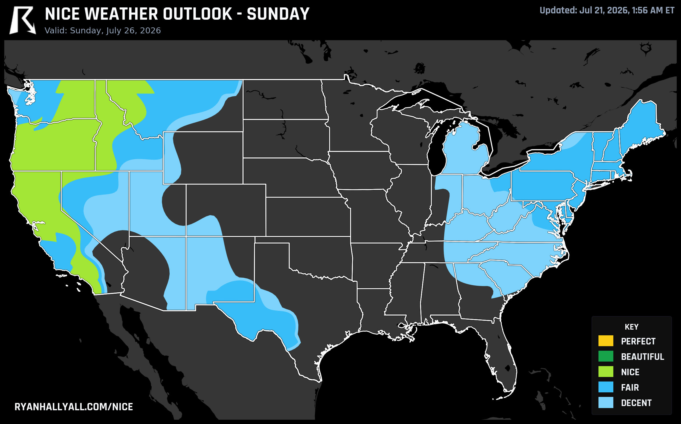
The broader pattern behind all of this, per the latest WPC guidance, is a western and central ridge that keeps building through the week while a weaker eastern trough slowly increases shower coverage from the Ohio Valley into the coastal Southeast. That ridge is also why the nicest weather keeps migrating. By Days 6 and 7, the best conditions in the country shift out toward the Pacific Northwest and Intermountain West, with Portland, Spokane, Boise, and the Tri-Cities all posting Beautiful-tier scores on dry, nearly cloudless air. It's the kind of pattern where California's Central Coast, Cascadia, and the Northeast all get a turn in the spotlight over the course of one week, just not all at the same time.
Caveats Worth Knowing
A few things to keep in mind if you're planning around any of this. UV is running high, generally 7 to 9, across nearly every zone mentioned here, so sun protection matters even on the prettiest days. Wildfire smoke is degrading air quality from the Upper Midwest into parts of the Pacific Northwest and keeping some otherwise-decent zones capped below Nice. And heat stress is a real limiter across the southern Plains and Southwest, where afternoon apparent temperatures are pushing past 100°F even in areas that look fine on a map. None of that erases the good news above, it just means read the fine print before you build a whole weekend around any one forecast.