Blog Article
California's Central Valley Nice Streak Hits 49 Days
Central Valley cities like Stockton and Sacramento have logged 49 straight Nice-or-better days despite the heat, while a Beautiful corridor builds into Ohio Wednesday.
California's Central Valley Just Quietly Ran Off a 49-Day Nice Streak, and Ohio Gets Its Turn Wednesday
Every few weeks the nice weather map finds a new favorite. This time it never left California's Central Valley, and it's been there so long almost nobody noticed.
49 days and counting, and it shouldn't work on paper
Stockton, Modesto, Sacramento, Shasta, Walnut Grove, Tracy, Manteca, Elk Grove, Hayward, Roseville, Concord, Berkeley, Fairfield, Napa, Citrus Heights, Antioch, San Leandro, Visalia, Shaver Lake and Arden-Arcade have all posted a live streak of 49 straight days at Nice or better, running back to early June. That's not a lucky afternoon. That's a season.
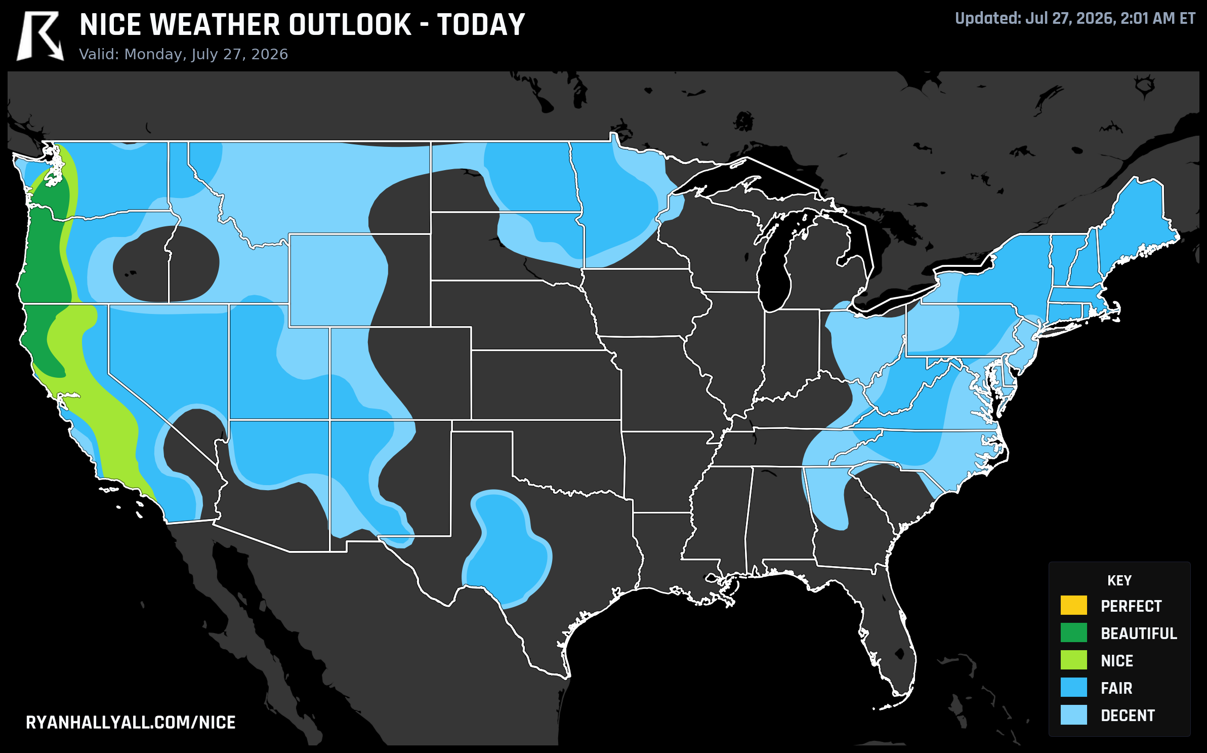
The strange part is that this streak is happening in a place that's currently running afternoon highs in the 90s to low 100s. Today's outlook has Fresno at 92°F and Sacramento region highs pushing similar numbers, which sounds like exactly the kind of heat that should knock a city out of contention. It doesn't, because the Nice Weather score isn't just a temperature check. In today's Nice zone covering the Central Valley, the heat-stress sub-score comes in at 75.4 out of 100, clearly the weakest link, but dewpoint (93.3), sky (98.9), precipitation (99.0) and wind (89.6) are all near-flawless. Bone-dry air, cloudless skies and zero rain chance are doing enough heavy lifting to keep the overall score in Nice territory even with real afternoon heat in the mix.
The honest caveat here is that this is Nice, not Beautiful, for a reason. Thirteen percent of the zone's sampled gridpoints today run hot enough to be excluded from the outlook entirely, meaning some Central Valley communities are too hot for any nice designation at all. If you're out there, this is a shade-and-water kind of nice day, not a linger-outside-till-sunset kind of nice day. UV is running around 8.0 zone-wide too, so sunscreen matters even under that clear Pacific-air sky.
The Pacific Northwest still owns the actual top score
If you want the single best air in the country today, it's still sitting over Portland, Tacoma, Salem, Eugene, Medford and Longview, all scoring Beautiful and sitting right at the edge of Perfect. The Day 1 discussion is blunt about why they don't get the top tier: every core comfort metric out there already clears the Perfect bar, with sub-scores for dewpoint, sky, wind and heat-stress all in the mid-90s. What's blocking it is a UV index of 7.7 and an AQI of 42, both just outside the strict Perfect gates of UV 7 or less and AQI 35 or less. Medford is arguably today's best individual read, 86°F under clear skies with a dewpoint of just 48°F. It just can't clear that last little gate.
Check the full Nice Weather outlook page if you want to see how tight that margin really is, because it's the same story tomorrow in Salem and Bangor, Maine, and again Wednesday across a wider stretch of the country.
Wednesday's twist: the Great Lakes and Ohio Valley get their turn
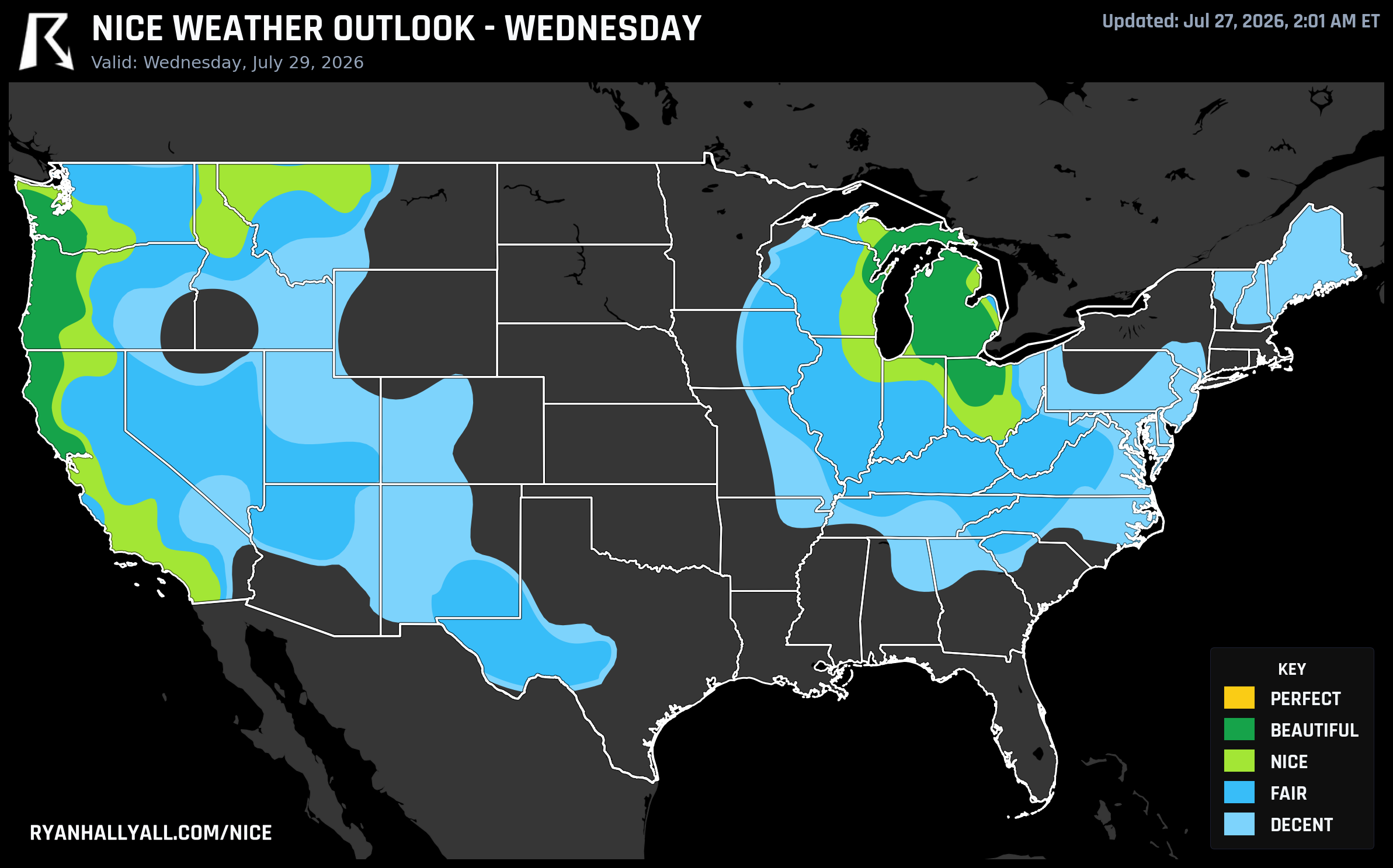
Here's the more interesting wrinkle. Right now the Storm Prediction Center has an Enhanced Risk posted for Chicago, Milwaukee, Indianapolis and Toledo today, with a real threat of damaging wind gusts as storms roll through tonight. That's not a nice-weather day for the Ohio Valley, and it shouldn't be treated like one.
But the same cold front behind that mess is what sets up Wednesday, July 29. Once the front clears, a corridor of Beautiful weather stretches from the Pacific Northwest coast all the way into the western Great Lakes and Ohio Valley, catching Toledo, Grand Rapids, Lansing and Santa Rosa at a score of 92. The Day 3 discussion credits a post-frontal airmass with essentially flawless dewpoint (98.3) and precipitation (100) scores, plus clean air behind the front. Northern Indiana, Ohio and Kentucky forecasters are calling it dry weather with excellent outdoor conditions, right as the Ohio State Fair opens in Columbus that same day. It won't hurt that the muggy, oppressive stretch that's been sitting over the Midwest all month finally breaks for a few days.
What holds it back from going further
Don't expect that Ohio Valley window to last. The extended discussion covering Days 4 through 7 is pretty clear that a persistent western and northern-central ridge keeps heat-stress exclusions cutting anywhere from 8 to 32 percent of the country's gridpoints out of the outlook entirely on any given day, and that Midwest and East Coast precipitation scores start sliding backward as a frontal boundary sharpens through the back half of the week. By Day 5, thirty-two percent of the lowest tier is too hot to even qualify as Decent, and severe gust flags start creeping back in behind another round of storms. The Pacific Northwest, by contrast, keeps grinding out Nice-to-Beautiful scores basically every day through Day 7, which is why it stays the most dependable name on the board even as everything east of it wobbles.
So the practical read for the week: California's Central Valley streak keeps rolling as long as that dry air holds, just build your outdoor plans around the cooler parts of the day. The Ohio Valley gets one genuinely good midweek window, worth using if you've got Ohio State Fair plans. And the Pacific Northwest remains the safest bet on the calendar, Perfect-adjacent but never quite tipping over that UV and air quality line.