Blog Article
Ohio Valley and Great Lakes Set for Beautiful Stretch Wed-Thu
A dry Canadian high brings back-to-back Beautiful-tier weather to the Ohio Valley and Great Lakes this week, right as the Ohio State Fair opens in Columbus.
The Storm-Battered Midwest Is About to Get the Best Two Days of Its Summer
Funny how this works sometimes. The same stretch of country that took a beating from a bowing MCS two nights ago, tornado warnings in Illinois, 90 mph radar-indicated gusts near Orland Park, a home collapse in Lansing, is about to get handed some of the nicest weather anywhere in the country. The front that caused all that trouble is the same front clearing the air behind it.
Today is a placeholder day, not the story
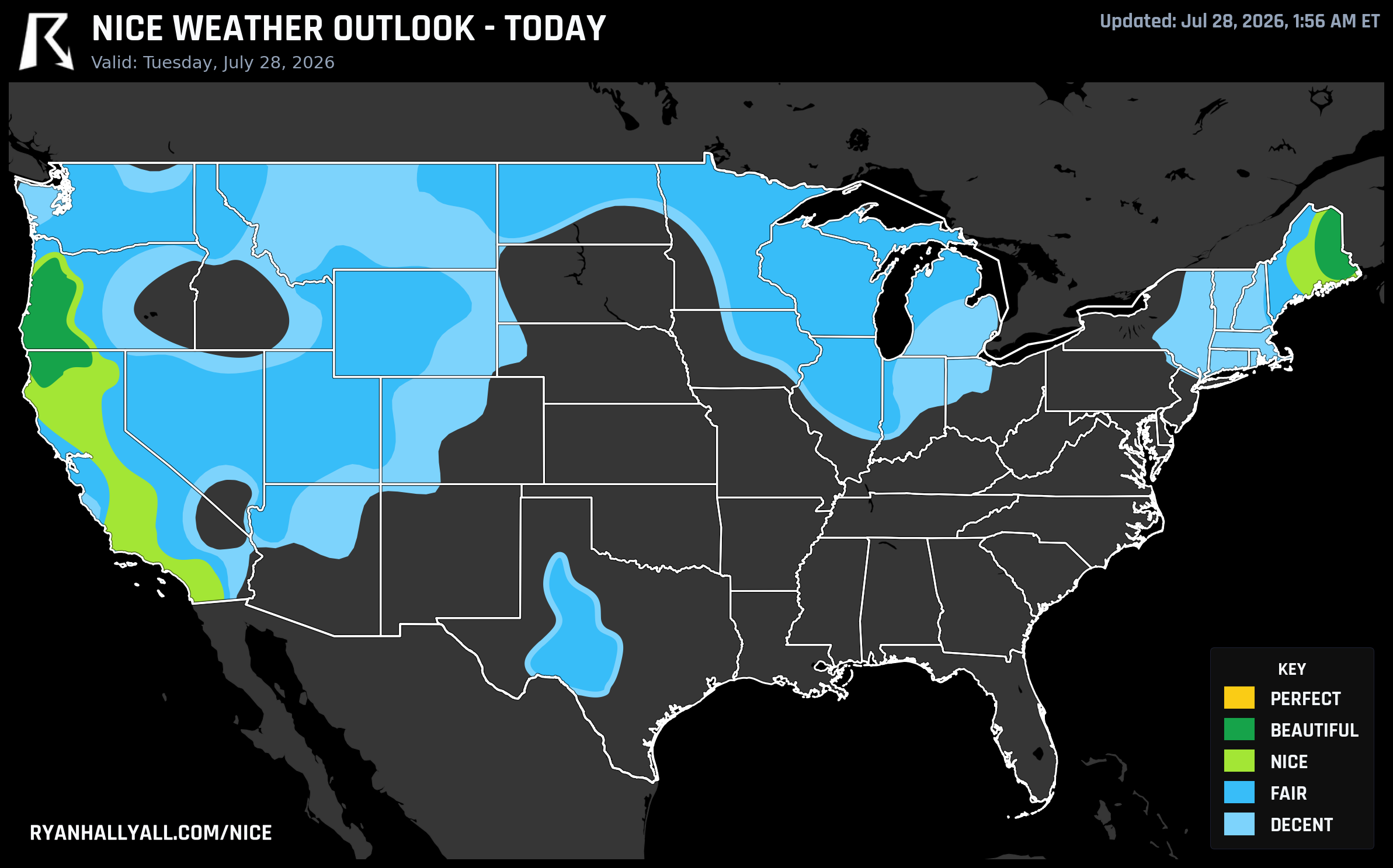
July 28 itself is a transition. The only true Beautiful pocket sits over the Willamette Valley in Oregon and far northern Maine, where Salem and Medford post scores of 92 with crisp low-50s dewpoints and barely any cloud cover. Everywhere else is settling for Fair to Nice, with California's coast and interior valleys running warm but dry, and a chunk of the Plains and Midwest still working through hot pockets and drifting wildfire smoke. If you're at a ballgame tonight in Detroit or Cincinnati, expect a mixed bag rather than a clean night. Today is worth knowing about, but it's not the headline.
Wednesday: the Ohio Valley and Great Lakes cash in
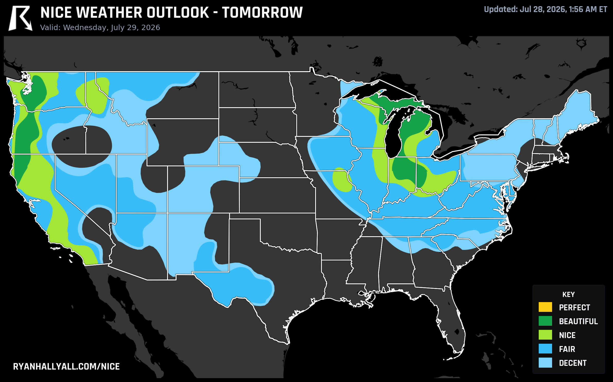
Here's where it gets good. Wednesday, July 29, a cold front sweeps the humidity out from under the Great Lakes and Ohio Valley, and a broad Beautiful zone settles in with a score of 87.2, the best of the whole outlook stretch. Fort Wayne, Dayton, South Bend, Carmel, and Lafayette all post clean 91-92 scores. Highs run a comfortable 79°F with dewpoints in the mid-50s and just 16 percent cloud cover. The Pacific Northwest tags along in the same zone, with Seattle joining Medford and Tacoma.
What's wild is how close this gets to Perfect without actually touching it. Every single sub-score, temperature, dewpoint, wind, sky, precipitation, heat stress, clears the 92-point bar that Perfect requires. The thing holding it at Beautiful is entirely gate-based: UV sits at 7.3 (Perfect needs 7 or under) and background AQI is 37 (Perfect needs 35 or under), both just barely over the line from lingering wildfire smoke aloft. It's about as good as a day gets without the ceiling actually opening up.
And if you want to see genuinely elite numbers, look north. A run of towns across Michigan's northern Lower Peninsula and Upper Peninsula, Gaylord, Indian River, Cheboygan, Mackinaw City, Petoskey, Sault Ste. Marie, are all individually posting scores in the high 90s on Wednesday, several topping 99. That's the single best pocket of comfort anywhere in this week's data.
Thursday holds, and the Ohio State Fair walks right into it
The pattern doesn't fade Thursday, it basically holds steady. A dry Canadian high settles fully overhead, and the Ohio Valley into the Great Lakes and Pacific Northwest scores 88.7, the day's ceiling. Columbus, Louisville, Cleveland, Lexington, Cincinnati, and Toledo all post 92s, with highs near 82°F, dewpoints in the mid-50s, and winds calming to around 9 mph as the ridge takes over. Sky cover averages just 14 percent. Same story as Wednesday: UV around 7.3 and AQI in the low 40s keep the door to Perfect just out of reach, but this is genuinely dry, sunny, comfortable air.
The timing lines up nicely for the Ohio State Fair in Columbus, which opens July 29 and runs right through this window. Anyone with fairground plans this week caught the good half of the calendar.
The caveats worth knowing
A couple of things to flag before you plan around this. UV runs in the 7 to 8 range across both days, so sunscreen still matters even with the cooler, drier air. Lake Michigan and Lake Superior are dealing with dangerous swimming conditions this week, 3 to 8 foot waves and strong rip currents from the passing front, so admire the lake from the shore rather than in it. And this comfortable window is regional, not national. The same days that feel this good in the Midwest come with a Moderate Risk of excessive rainfall today across the Tri-State area of New Jersey, New York, and Connecticut, plus a Slight severe thunderstorm risk stretching from the Mid-Atlantic into the Carolinas. Meanwhile WPC's extended outlook is already flagging a long-duration Western heat wave building for the weekend into next week, so if you're out in California or the Great Basin, this is not your stretch.
The Pacific Northwest keeps doing its quiet thing
While the Midwest gets its two-day moment, Medford, Roseburg, and a long list of small towns across southern Oregon and northern California have simply never left the good side of the ledger. Medford leads the entire week's rankings with a 7-day mean score of 86.3 and a best-day score of 92, and it's not alone, more than twenty towns in that Oregon-to-Ukiah, California corridor share the exact same profile. If you want the full current picture of who's riding high and who isn't, the Nice Weather outlook page has the live rundown.
Bottom line: if you've got flexibility this week, Wednesday and Thursday in the Ohio Valley and Great Lakes are the days to grab a patio table, get to the fairgrounds early, or just leave the windows open. It won't touch Perfect on paper, but it's about as close as this pattern gets.