Blog Article
Upper Midwest Nears Perfect Weather, But Smoke Keeps Blocking It
Fargo, the Twin Cities, and the Great Lakes each hit Beautiful-tier weather this weekend, but wildfire smoke keeps pushing AQI and UV just past the Perfect threshold three days running.
Three Straight Days of Nearly Perfect, and Wildfire Smoke Keeps Slamming the Ceiling Shut
Y'all, we flagged a shot at Perfect for the Minnesota border towns in yesterday's post, and the latest numbers came in just a hair short. Baudette is sitting at a 99.3 today, which is about as good as a score gets without crossing the line, but its effective AQI landed at exactly 35 and UV came in at 7.2 — both just on the wrong side of the gates that Perfect requires. That's today's whole story in miniature, and it turns out it's also tomorrow's story, and Monday's too. Three days in a row, the sub-scores for temperature, dewpoint, wind, sky, and precipitation are basically maxed out across a shifting stretch of the Upper Midwest and Great Lakes. The only thing keeping the top tier out of reach is a persistent smudge of wildfire smoke aloft, tied to the Pacific Northwest and Canadian fires that keep AQI and UV pinned just above the Perfect thresholds.
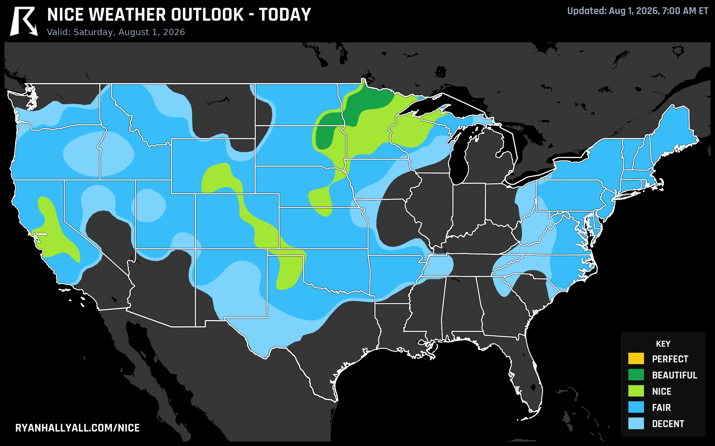
Today: Fargo and the Northern Minnesota Border
Saturday's best air sits in a pocket running from Fargo into Aberdeen, Bemidji, Baudette, and Nashwauk, where clear skies, light wind, and dry Canadian air have built a genuinely Beautiful day. The zone as a whole scores 88.1, and every sub-score is elite: precipitation and sky both essentially maxed, wind averaging just 6.9 mph, dewpoints in the low 60s. Fargo itself checks in at 81.1, still comfortably in Beautiful territory with a high near 82°F. This is patio-breakfast, screen-door-open weather if you're anywhere in that stretch today.
Elsewhere, San Jose, San Francisco, Denver, Minneapolis, Amarillo, and Sioux Falls are all sitting in the Nice tier today, in the high 70s to low 80s on the 0-100 scale. Denver's ceiling is capped mainly by AQI in the high 70s, which is worth knowing if you're headed to Coors Field tonight for Royals-Rockies — skies should be dry and winds manageable, just don't expect the cleanest air in the ballpark.
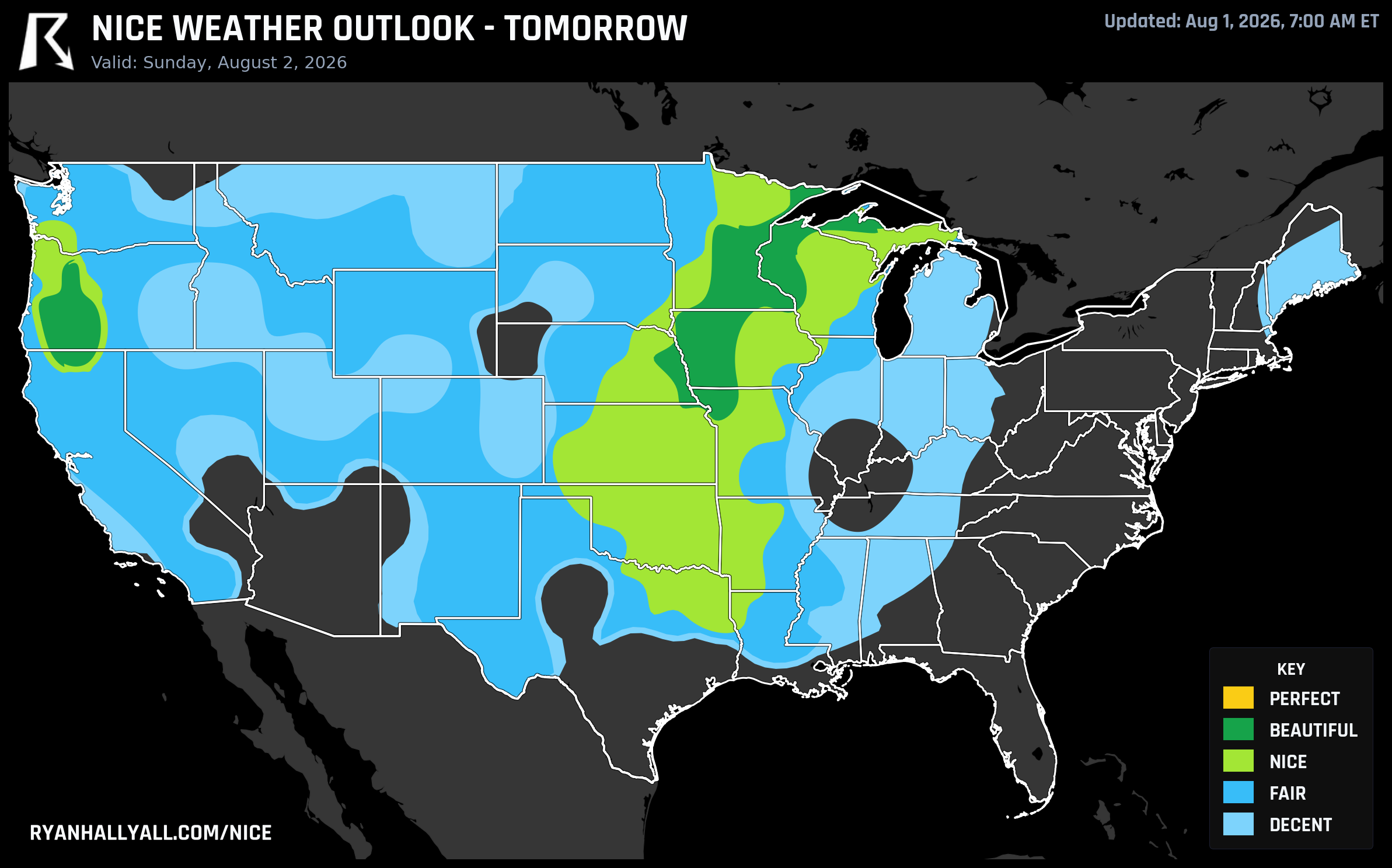
Tomorrow: Even Better Numbers, Same Ceiling
Sunday actually improves on today, at least on paper. Omaha, Minneapolis, Rochester, Eau Claire, St. Cloud, and La Crosse are all posting scores between 91.6 and 92.0, comfortably in Beautiful territory, with highs in the low-to-mid 80s and dewpoints near 60°F. Every single sub-score in that zone clears the 92-point bar that Perfect would require — precipitation, sky, temperature, dewpoint, wind, and heat stress are all north of 94. The zone's overall score of 87.7 undersells just how good the raw weather is.
So what's blocking the jump to Perfect? The same two culprits as today: UV index averaging 7.4 (the gate is 7 or under) and AQI averaging 43 (the gate is 35 or under). Both are close enough that a slightly cleaner air mass would have tipped this into the top tier, but close doesn't count. If you're catching the Royals and Rockies again Sunday night in Denver, or just planning a Twin Cities weekend, this is as good as August gets around here without technically being the best it can be.
Monday Makes It Three
The pattern holds one more day before it starts to break down. Monday's best weather shifts to the central Great Lakes and Ohio Valley — Milwaukee, Grand Rapids, Green Bay, Saginaw, and Marquette — where a building ridge produces a 90.3 zone score, the best raw number of the stretch. Green Bay and Saginaw post individual scores of 92.0 with highs around 80°F, dewpoints in the upper 50s, and cloud cover down to 4%. But Monday's forecast-day rules only allow a Beautiful ceiling regardless of how clean the numbers get, and the zone's peak AQI of 45 would have blocked Perfect anyway. Same story, different city names.
A caveat worth sitting with: Monday also comes with a Slight Risk of severe thunderstorms in the Ohio Valley and Tennessee Valley, and WPC has a parallel excessive rainfall risk running from the Upper Midwest to the Gulf Coast. None of that touches the Great Lakes Beautiful pocket directly, but it's a reminder that the map right next door can look very different.
The Week Ahead Loses Some Altitude
Starting Tuesday, the pattern shifts. An entrenched ridge near the Four Corners, confirmed in CPC's extended outlook, caps every zone at Nice through Day 7 and pushes the best conditions progressively west, from the northern High Plains on Day 4 into the interior Pacific Northwest and northern Rockies by Day 6 and 7. Heat-stress exclusions climb from 14% of sampled area on Day 4 to 29% by Day 7 as the ridge holds and afternoon heat index values push into the 100s across the Plains and South. Seattle, Portland, Eugene, and Santa Rosa become the recurring names on the leaderboard, though Seattle and Portland's scores hover in the 77-82 range rather than anything historic. Pair that with an Extremely Critical fire weather day today across the Columbia Basin of central/southeastern Washington and northern Oregon, and it's a reminder that the same ridge delivering pleasant afternoons out west is also drying out the landscape underneath it.
A Quieter Kind of Nice: California's Long Streaks
While the Upper Midwest and Great Lakes are having their moment in the spotlight, a cluster of Northern California towns has been putting together the most durable stretch of the summer without much fanfare. Shasta, Walnut Grove, Sacramento, Oakland, Stockton, Modesto, Napa, and about a dozen other Central Valley and Bay Area communities are all sitting on 54-day live streaks of Nice-or-better conditions, the longest active streaks anywhere in the country. It's not the flashiest weather — marine influence and inland heat trade off day to day rather than delivering standout Perfect scores — but it's remarkably consistent. Laytonville and Hopland, up in Mendocino County, are this week's top-ranked cities nationally with a full seven Nice days out of seven, peaking at 92.0 apiece.
For the full day-by-day picture, including which zones are gated by AQI versus which ones are gated by the calendar itself, the Nice Weather outlook page has the current maps and city rankings updated as the smoke and heat shift around. Between now and Monday, though, the move is simple: Upper Midwest and Great Lakes for the best air on the map, with the caveat that "best" this week still means Beautiful, not Perfect, and smoke aloft is the reason why.