Blog Article
Beautiful Air Sweeps East Before Heat Dome Takes Over This Week
A near-Perfect air mass moves from the Great Lakes into the Northeast this week before a building heat dome pushes the best weather out to the Pacific Northwest by the weekend.
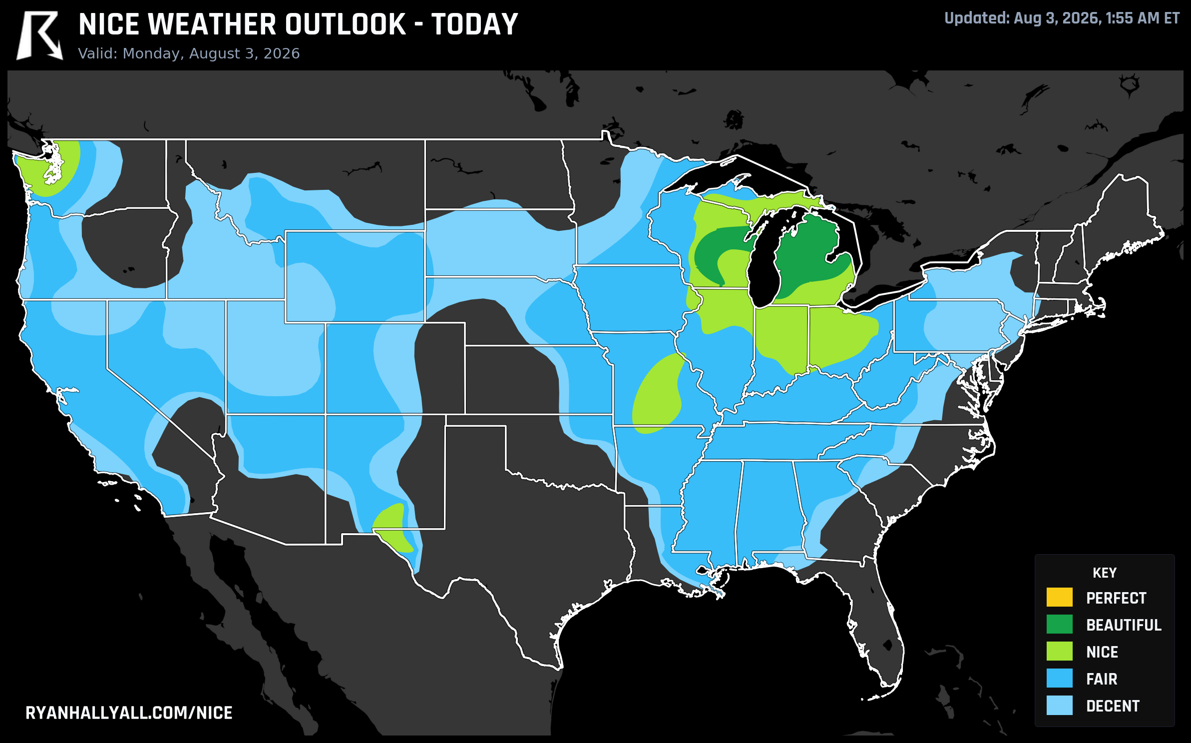
A Two-Day Beautiful Sweep Rolls From the Midwest to the Northeast, Then the Heat Dome Takes the Wheel
If you're eating breakfast on a patio in Madison, Grand Rapids, or Green Bay this morning, you picked a good week to do it outside. A dry Canadian high has scrubbed the humidity almost completely out of the central Great Lakes and Ohio Valley, and what's left is about as close to textbook early August as the sky gets: highs near 80, dewpoints in the 60s, 6 percent cloud cover, and a 1 percent chance of rain. Grand Rapids and Green Bay are both sitting at 92 out of 100 today, with the zone averaging 90.1. That number isn't an accident of the scoring, either. Every single sub-score in this zone, from temperature to wind to heat stress, actually clears the threshold required for our top tier, Perfect. What's holding it at Beautiful instead is air quality sitting right around 42 AQI and UV at 7.0, both just outside the gates that Perfect requires. The weather itself is there. The air just isn't quite clean enough, and the sun is just strong enough, to let it through.
Here's the fun part: this exact air mass doesn't stop in Michigan and Wisconsin. Tomorrow it slides east and does almost the same thing to the Ohio Valley, Great Lakes, and Northeast. Columbus, Fort Wayne, Rochester, Springfield in Massachusetts, Syracuse, Allentown, and Erie all land in the Beautiful tier, and the zone-wide score of 90.5 tells the identical story as today: every sub-score clears the Perfect gate on paper, but AQI around 42 and UV around 7.3 keep the label at Beautiful. Winds stay light everywhere, 5 to 11 mph, skies run better than 90 percent clear, and rain chances sit near zero. If you're catching the Nationals at the Phillies in Philadelphia tonight, you're technically a notch below this air mass in the Fair tier, but if you're at Wrigley for Dodgers-Cubs, Chicago's sitting comfortably in Nice territory with manageable dewpoints. Either way, this is a genuinely good 48 hours to be outside almost anywhere east of the Mississippi.
Wednesday the story shifts geography without losing quality. The best air moves into the northern Plains and upper Midwest, where Fargo and St. Cloud post 92s of their own, with highs in the low-to-mid 80s and dewpoints down in the mid-40s. Because Day 3 forecasts carry a lower-confidence cap in our system, Beautiful is the ceiling regardless of how the raw score reads, but that's a technicality, not a knock on the weather. Southern California's coast quietly joins the party too, with San Diego, Long Beach, and Santa Rosa all landing in the Nice tier as monsoon moisture stays mostly offshore for now.
Then the Ridge Takes Over
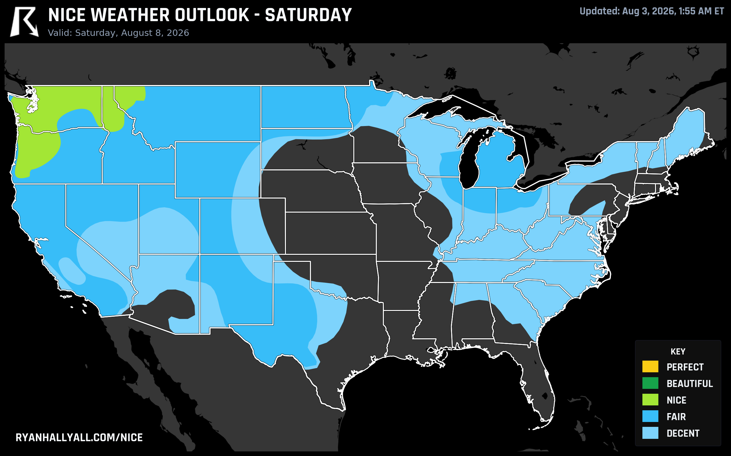
Starting Thursday, the pattern flips. A stubborn upper ridge builds over the central CONUS and, per the WPC extended discussion, expands northeast through the week, dragging serious heat into the Plains, Midwest, and eventually the South. The practical effect on our outlook: the best available tier drops to Nice for the entire Day 4 through 7 stretch, and the geography of that Nice tier retreats northwest day by day, from the northern Plains on Thursday and Friday to the Pacific Northwest and northern Rockies by the weekend. Heat stress becomes the dominant limiter, with as much as a third of the lower-tier zone running too hot to even qualify as Decent by Saturday.
That matters if you've got plans. The Wisconsin State Fair opens in West Allis on Thursday, right as Milwaukee slides toward the rough edge of this pattern, with our data showing the metro dipping into the 50s on our scale thanks to cloud cover, rain chances, and a muggier dewpoint. Eau Claire, La Crosse, and Wausau up to the north fare noticeably better and stay in Nice territory the same day. The Sturgis Motorcycle Rally kicks off Friday in South Dakota, sitting inside that same broad northern Plains zone earning Nice marks through Day 5, though we don't have rally-specific numbers to hang a promise on.
By Saturday and Sunday, the best weather in the country has effectively moved to the coast. Seattle, Portland, Spokane, Salem, Eugene, and Bend all reach Beautiful on Day 6, with highs settling into the 80s, dewpoints in the low 40s, and essentially no rain. Sunday extends that further south, with Los Angeles, San Diego, and Riverside joining Seattle and Portland at 82 apiece. If you're headed to Outside Lands in San Francisco that weekend, the broader Bay Area and Sonoma County zone (Santa Rosa, Petaluma, Novato) has been running some of the best average scores in the country all week, a nice bonus for anyone road-tripping wine country before or after the festival.
A Few Things to Watch
A couple of caveats worth keeping in your back pocket. Wildfire smoke is a live concern in parts of the Inland Northwest after this week's destructive Spokane-area fires, and it's already knocking otherwise-dry, comfortable air out of the Nice tier in spots like Coeur d'Alene. UV sits in the 7-to-8 range for most of the country's best zones, so the usual midday sun protection still applies even on a gorgeous day. And CPC's week-two outlook flags a moderate risk of extreme heat expanding across the Central and Southern Plains into the middle of August, so this ridge isn't packing up quickly.
Meanwhile, out in California's Central Valley, cities like Sacramento, Stockton, Modesto, and Oakland are riding a 56-day streak at or above the Nice threshold, one of the longest active streaks we're tracking. Consistency has its own kind of charm, even without a headline Perfect day attached to it.
For the full breakdown by city and day, the Nice Weather outlook page has the complete rankings, and it's worth checking again midweek once the heat dome fully sets its feet.