Blog Article
Nice Weather Outlook: Ohio Valley Today, PNW All Week
Columbus and Syracuse peak near-Perfect today, Minneapolis takes over tomorrow, then the Pacific Northwest becomes the week's most reliable nice weather zone.
Ohio Valley and the Northeast Get Today's Best Air, Then the Nice Weather Baton Heads West
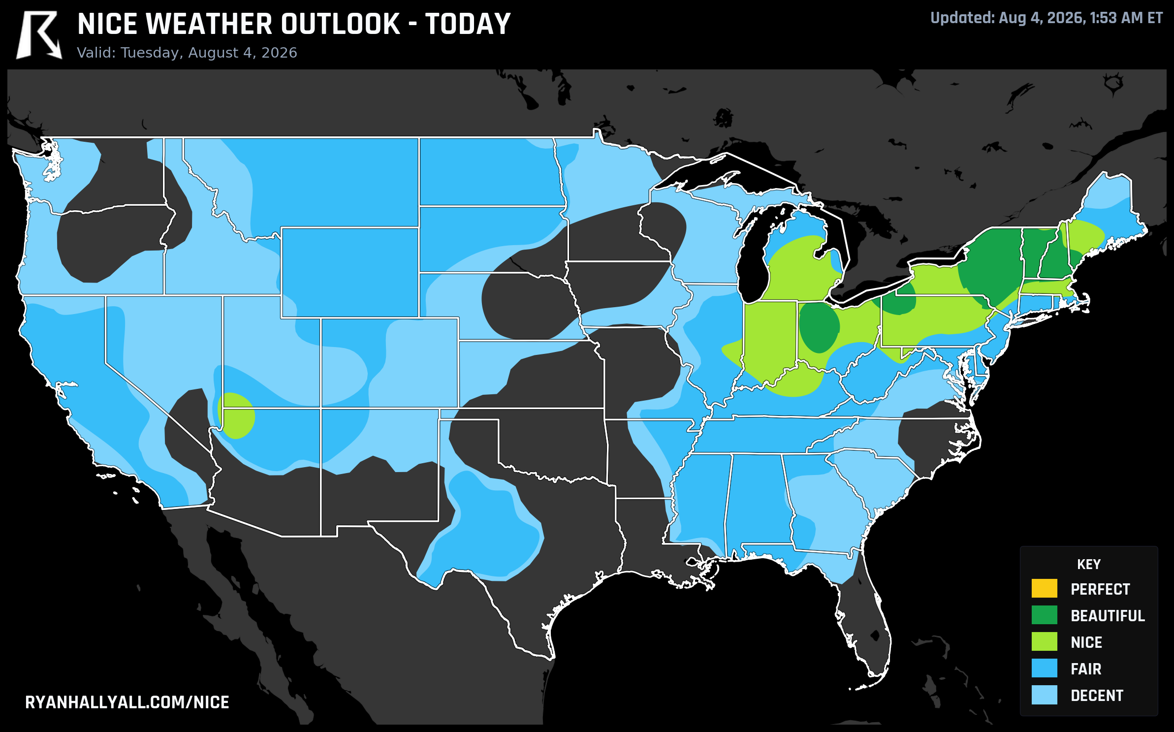
If you're eating breakfast on a patio anywhere from Columbus to Albany this morning, you picked a good day for it. A cold front that dumped nearly five inches of rain on parts of New Jersey yesterday has cleared out, and what it left behind is about as clean as early August gets: dewpoints in the 50s, cloud cover you can count on one hand, and highs that feel like a preview of September.
Today: So Close to Perfect You Can Taste It
Columbus (81.7), Toledo (81.3), and Dayton (81.9) are all sitting in the Beautiful tier today, but the real story is a cluster of cities pegged right at 92, Syracuse, Manchester, Erie, Albany, Utica, and Binghamton among them. Every comfort category in this zone is nearly maxed out. Sky cover averages 2 percent. Precipitation chance is zero. Heat stress barely registers. What's keeping the whole swath from crossing into Perfect isn't a weak number anywhere, it's two hard gates: UV sits at 7.3, just above the Perfect ceiling of 7, and the zone's air quality reading of 40 to 52 clips the tighter Perfect cap of 35. So it's Beautiful, not Perfect, by a matter of inches. If you're at Progressive Field in Cleveland tonight for Guardians and Mets, you're sitting in that same dry Ohio air mass that's carrying Columbus and Toledo, expect a comfortable evening with low humidity and clear skies.
Tomorrow: The Reins Pass to Minneapolis and the Dakotas
A fresh shot of Canadian air follows right behind today's front, and it sets up Wednesday's best zone over the northern Plains and Upper Midwest. Minneapolis leads at 92, with Sioux Falls (91.6), Eau Claire (91.4), and Mankato (91.3) close behind. Highs only reach the high 70s to mid 80s, dewpoints run 48 to 54 degrees, and cloud cover stays under a quarter of the sky. Same story as today though, wind averaging 11 mph with gusts near 18 and an AQI of 42 keep this zone one tier under Perfect even though it's technically eligible for it on the calendar.
Midweek: The Window Narrows as the Ridge Builds
After Wednesday, the pattern tightens. A persistent ridge that CPC and WPC both flag in their extended guidance starts locking heat and humidity over the Plains, Midwest, and South, capping big chunks of the country at Fair or Decent even as temperatures stay near normal. By Thursday, the best conditions shrink to a scattered band running from the Upper Midwest into the northern Rockies and Pacific Northwest, Rochester, Eau Claire, La Crosse, and Wausau are the standouts, all in the Nice tier. Milwaukee's forecast office was one of the ones feeding that day's outlook, so if you're headed to the Wisconsin State Fair in West Allis on Thursday, you're on the edge of that same cooldown, expect comfortable temperatures even if the ballpark score doesn't quite reach the western Wisconsin numbers.
Down in San Francisco, Outside Lands kicks off Friday under a Fair-tier day (score 69.3), with the marine layer keeping things mild rather than the AQI or heat problems dogging much of the rest of the country. Not the week's best weather, but far from bad for a festival crowd.
The Real Winner This Week: The Pacific Northwest
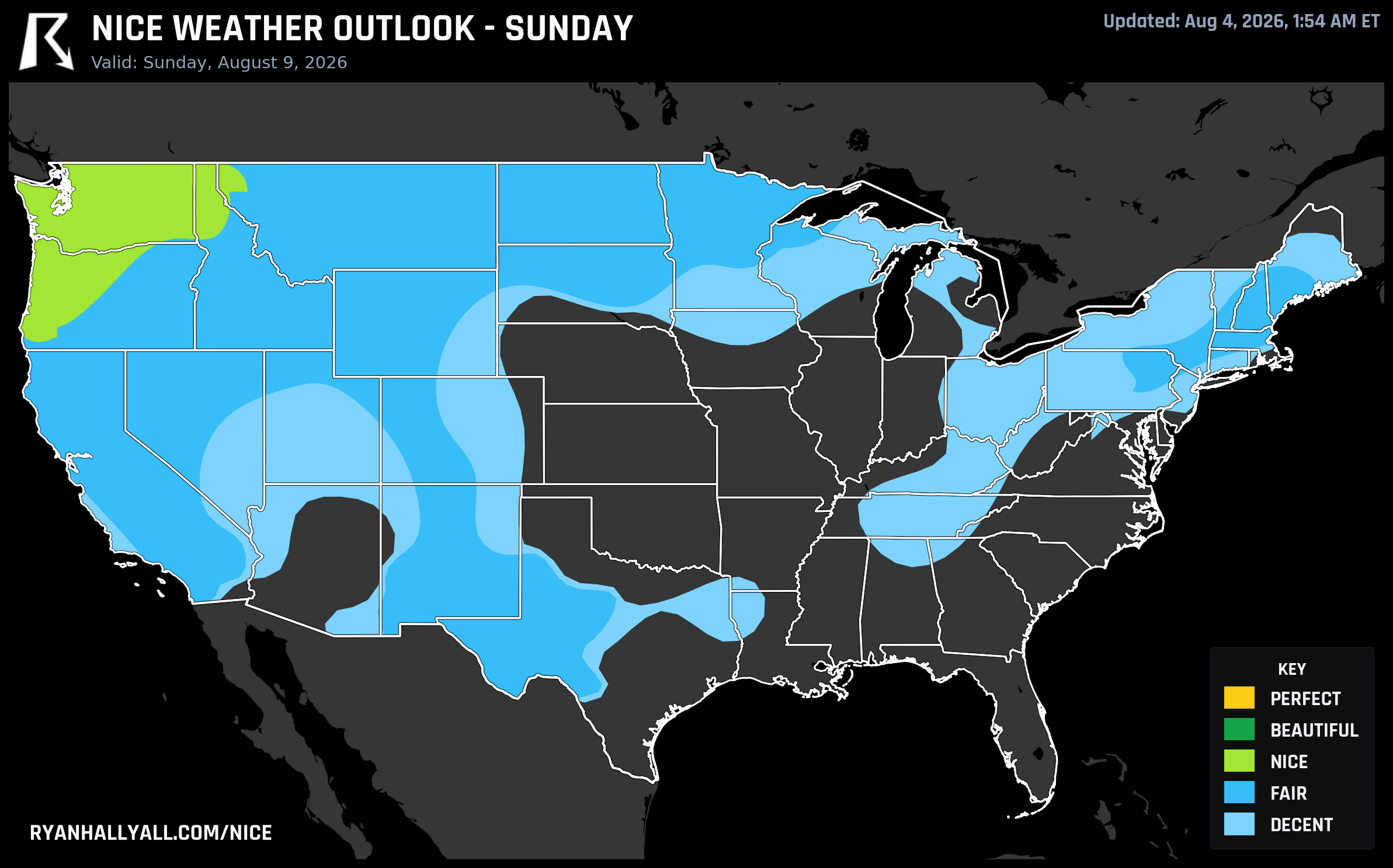
This is where the pattern gets interesting. As the ridge strengthens over the Southwest and expands into the Intermountain West through the weekend, per WPC's extended discussion, a trough digs into the Northwest and keeps that corner of the country comfortable straight through the period. Seattle and Portland post a clean Beautiful score of 79.0 on Day 5, then climb to 82.0 by Day 6 alongside Spokane, Salem, Eugene, Bend, and the Tri-Cities. By Day 7 the Nice tier stretches all the way down into California, with Los Angeles, San Jose, and Riverside joining Seattle and Portland at 82.0. It's the most stable stretch of good weather anywhere on the map this week, precipitation and sky scores near 100 across the board, wind mostly light, and none of the heat stress problems piling up elsewhere.
The Longer Game: California's North Coast
Zoom out to the full week and the weekly rankings tell a similar story from a different angle. Hopland, Cloverdale, Santa Rosa, Petaluma, and a string of Sonoma County towns are averaging around 81 out of 100 across all seven days, with several logging a Nice grade on every single one. Farther south in the Central Valley, Sacramento, Stockton, Modesto, and a dozen other cities are riding 57-day streaks at or above the Nice threshold, which is a genuinely long run. Worth a caveat here though: broader guidance is flagging some of these same areas, Sacramento and the Central Valley included, for triple-digit heat and elevated fire weather risk in the afternoons. Read that streak as a mornings-and-evenings kind of comfort, not an invitation to spend 2 p.m. in full sun without water and a hat.
For the interactive maps behind all of this, city by city, day by day, the Nice Weather outlook page has the full breakdown.
Bottom line for planning purposes: if you're in the Ohio Valley or Northeast, today's your day. Upper Midwest, that's tomorrow. And if you've got flexible travel plans later this week, the Pacific Northwest is shaping up to be the one region that just keeps delivering, day after day, while the rest of the country works around a stubborn ridge of heat.