Blog Article
Nice Weather Today: Minnesota's Near-Perfect Pocket, PNW Rises
Today's best air sits over south-central Minnesota, one AQI point from Perfect, while Bangor's State Fair and WE Fest catch a comfortable day too. See where the week's nice weather heads next.
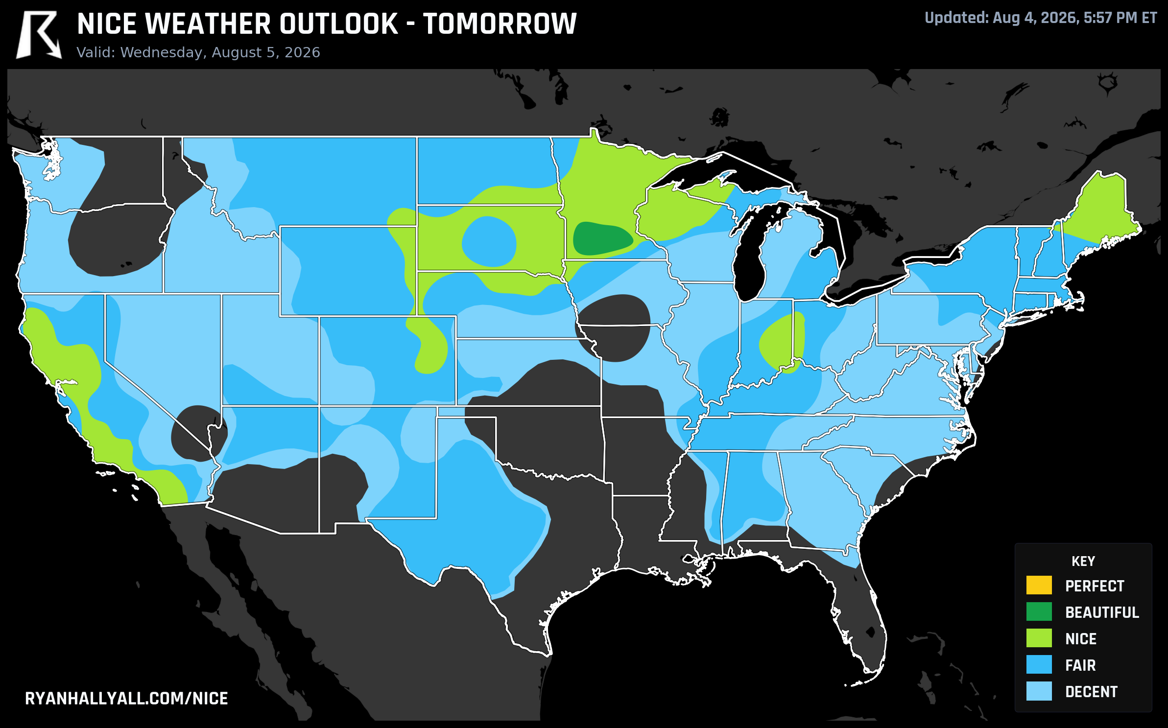
A Sliver of Almost-Perfect Sits Over Minnesota While the Nice Weather Baton Heads West
If you're anywhere near Eden Prairie, Mankato, Willmar, or Hutchinson, Minnesota today, you landed on the best patch of weather in the country almost by accident. That little cluster is scoring 91.9 out of 100, and here's the part that'll make a meteorologist wince: it's sitting just 0.1 points from Perfect. Dewpoint, precipitation, wind, and heat stress are all already maxed out at 100. The only thing holding it back is air quality. The zone's effective AQI reads 48, and Perfect demands 35 or cleaner. It's smoke aloft, not anything you'd notice walking outside, but the data doesn't care about vibes. Eden Prairie and Willmar both post 92.0, Mankato sits at 91.3, and Hutchinson dips to 82.0. Faribault, in the same pocket, only manages 71.3 once you account for a slightly higher rain chance and more cloud cover, a good reminder that even inside a great zone the margins are thin.
Fair-Goers Catch a Break in Two Different States
Today also happens to be the day Bangor, Maine kicks off its State Fair, and the timing worked out. Bangor is riding the broader Upper Midwest/Northeast Nice-tier swath at a score of 81.5, with a high near 87 and a dewpoint around 59, comfortable by August standards even if it's not the headline pocket out in Minnesota. A few hundred miles west, Detroit Lakes, Minnesota is opening WE Fest today too, and while there's no city-specific score for it in the data, it sits inside that same broad Nice zone (77.2 zone average) that's benefiting from a dry high pressure setup pushing across the Upper Midwest.
That broader zone is a good example of a near-miss that isn't really about comfort at all. Every individual sub-score inside it, temperature, dewpoint, sky, wind, actually clears the bar for Beautiful. What keeps it at Nice is the same air quality story as Minnesota's Beautiful pocket, just worse: a zone effective AQI of 63, driven by Pacific Northwest wildfire smoke drifting overhead. It's visible haze more than a health concern at ground level, but it's enough to cap the ceiling.
Tomorrow: Wisconsin Gets Split Right Down the Middle
Thursday's outlook pushes the best air across the northern half of Wisconsin, Green Bay (81.5), Oshkosh (81.7), Eau Claire (81.2), La Crosse (81.3), and Wausau (81.1) all land in the Nice tier, alongside Rochester, Minnesota (81.8) and Santa Rosa, California (80.8). But the Wisconsin State Fair opens that same day in West Allis, right in the Milwaukee metro, and Milwaukee itself isn't part of that good-air club. The discussion behind Thursday's outlook singles it out as the laggard in a lower-scoring zone, dragged down to around 56.7 by a 39 percent shower chance and a muggy 67-degree dewpoint. So if you're heading to the fair, plan on soupier, stickier air than what the rest of the state is enjoying an hour or two north.
Why the Rest of the Map Is Stuck
None of this is really about clouds or wind. The WPC's short-term discussion flags a Slight Risk of excessive rainfall today from the Central Plains into the Middle Mississippi Valley and along the South Carolina coast, and a Marginal severe risk stretches from the Mid Mississippi Valley into the southern High Plains. Meanwhile, the CPC's extended outlook is blunt about what's coming: a heat wave holds over the Southwest through the weekend, then expands into the Central US and Southeast next week. That ridge is the reason so many Nice-tier zones this week are getting capped not by rain or wind, but by heat stress and haze. Denver, El Paso, and Chicago keep showing up as the softer edges of otherwise decent zones, and out west, Oregon's wildfire season is already forcing ranchers to evacuate cattle, a reminder that the same smoke thinning out AQI scores in Minnesota and the Northeast has real consequences closer to its source.
The Longer Play: The Pacific Northwest Takes Over
Zoom out to the extended period and the pattern gets simpler to read. WPC's four-day discussion for Days 4 through 7 describes Nice weather staying pinned to the Pacific Northwest and northern Rockies through Saturday, then expanding south into California and the Intermountain West by Sunday. Seattle, Portland, Salem, and Eugene post scores in the 77 to 82 range from Friday through Sunday, with precipitation and wind sub-scores essentially maxed out and no heat stress cap in play at all, a rarity this week. By Sunday, August 10, the confidence is lower since we're five days out, but the current data has Los Angeles, San Jose, Seattle, and Portland all reaching 82.0 in the Nice tier together, which would be the first day this week California and the Northwest share the same tier at the same time.
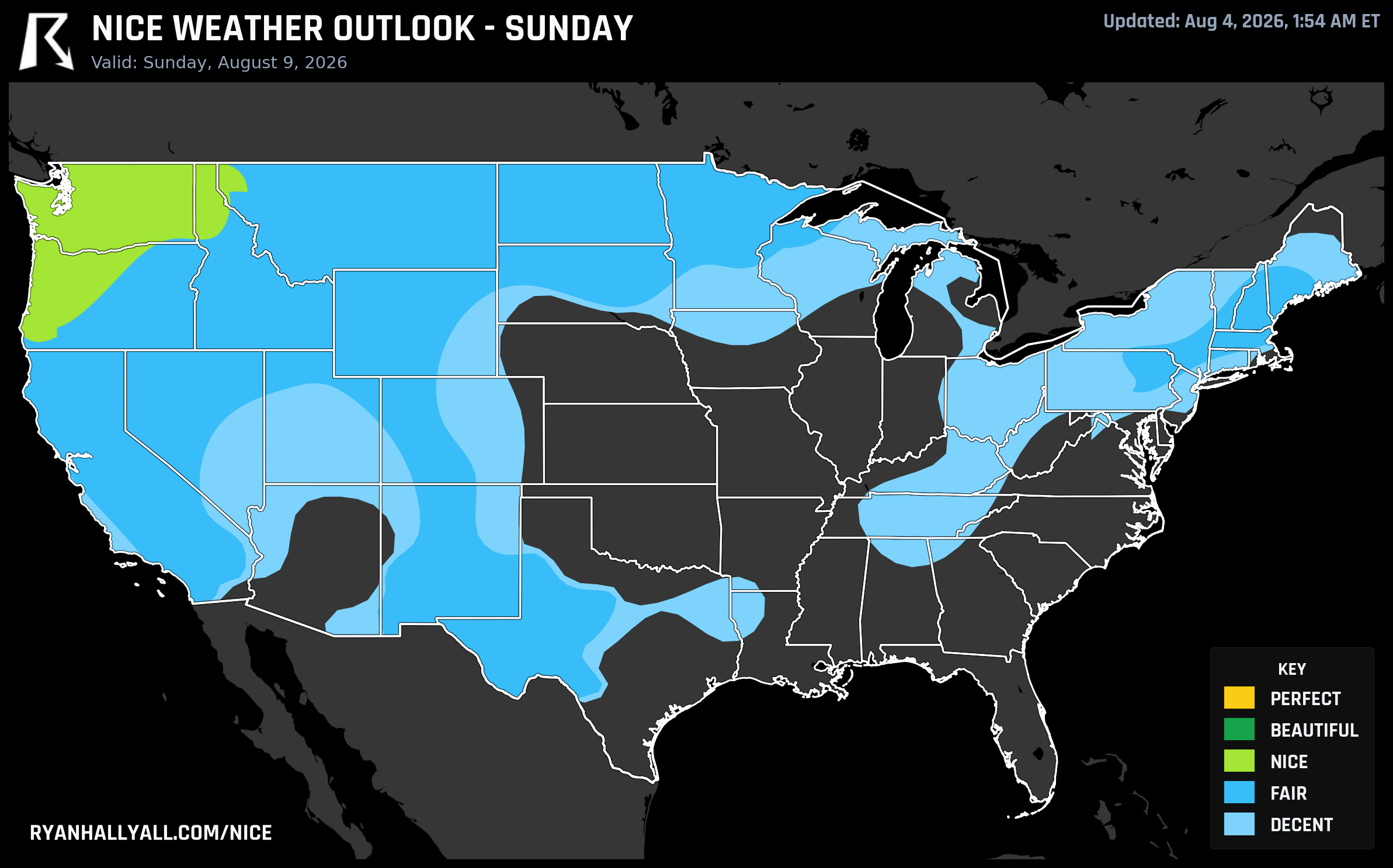
If you're the type who plans travel around comfort rather than just temperature, the Nice Weather outlook page is worth bookmarking through the weekend. This week's story isn't one big beautiful stretch, it's a series of small, smoke-thinned near-misses chasing a bigger, more reliable payoff out west.