Blog Article
Nice Weather Today: NorCal Coast Peaks, Sturgis Gets Lucky Tomorrow
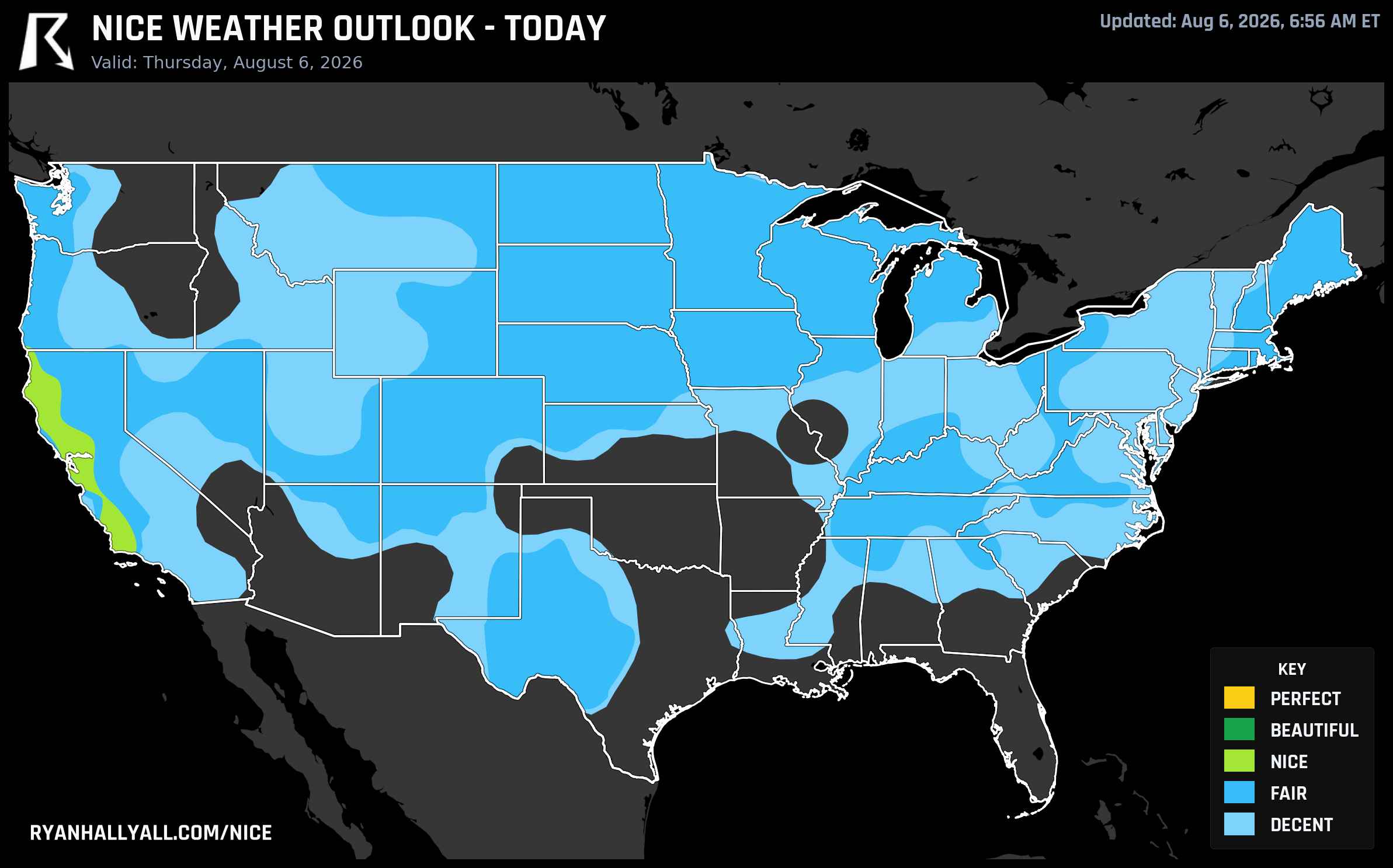
Today's best weather sits along the Northern California coast and Wine Country. Tomorrow the Montana Hi-Line goes Beautiful right as riders roll into Sturgis.
Wine Country Peaks Today, Then the Nice Weather Baton Rides North to Sturgis Country
If you're anywhere from San Jose up through Santa Rosa and Ukiah today, you're sitting on the best patch of comfort in the country. It's not flashy. Nobody's calling it Perfect. But it's real, honest Nice weather, and on a day when most of the map is either baking or breathing smoke, that counts for something.
Today: the coast and Wine Country carry the day
San Jose leads the pack at a score of 77.8, with Santa Barbara (81.4), Santa Rosa (80.8), and Santa Maria (80.0) all right there with it. Individually, Ukiah is the sleeper pick at 81.2, backed by a crisp 54.4°F dewpoint, wind barely above a whisper at 8.6 mph, and only 13 percent cloud cover. The formula behind all of it is simple: clean air, light wind, and a sky with almost nothing in it. Precipitation and sky scores are essentially maxed out at 100 across this zone.
What keeps this from tipping into Beautiful is air quality, not the weather itself. The zone's effective AQI runs around 73, above the 50 ceiling the next tier up would require. San Francisco and Eureka also lag a bit behind their neighbors, thanks to onshore cloud cover holding steady near 65 to 70 percent through the morning.
One quiet detail worth flagging: Sacramento's streak of at least Fair conditions has now run 59 straight days, tying it with Stockton, Modesto, Oakland, and a long list of Central Valley cities on the same streak. Today Sacramento actually crossed the line into Nice itself, scoring 77.1, which is a nice cap on a run that's held up through a genuinely hot summer.
Elsewhere today, don't expect much company. Medford, Oregon is flirting with a record high near 106°F, Boise is past 100, and the Mojave Desert is pushing 110. The East is muggy and stormy, with a Slight Risk of severe thunderstorms today over southeast Kansas into northwest Arkansas, and a broad Marginal risk stretching from Tulsa to Baltimore. If you're heading to Outside Lands in San Francisco this weekend, today's the more comfortable day to be outside before the festival even opens.
Tomorrow: the Montana Hi-Line goes Beautiful, and Sturgis riders get lucky
Friday flips the map. The nation's best weather shifts almost 1,500 miles north to a narrow stretch of the Montana Hi-Line: Havre, Glasgow, Malta, Chinook, and Fort Belknap Agency. This zone posts a score of 88.1, landing in Beautiful, and the underlying numbers are almost embarrassingly good. Precipitation, sky, wind, temperature, dewpoint, and heat stress are all already strong enough to qualify for Perfect on their own. Highs run 80 to 81°F, dewpoints sit in the low-to-mid 40s, and wind is a gentle 10 mph.
What holds it at Beautiful instead of Perfect isn't the weather. It's the gates. UV sits at 7.2, just above the 7.0 ceiling Perfect requires, and effective AQI reads 49, just above the 35 threshold. This is a day that's weather-Perfect but gate-capped, mostly by wildfire smoke drifting in from the region's ongoing fires.
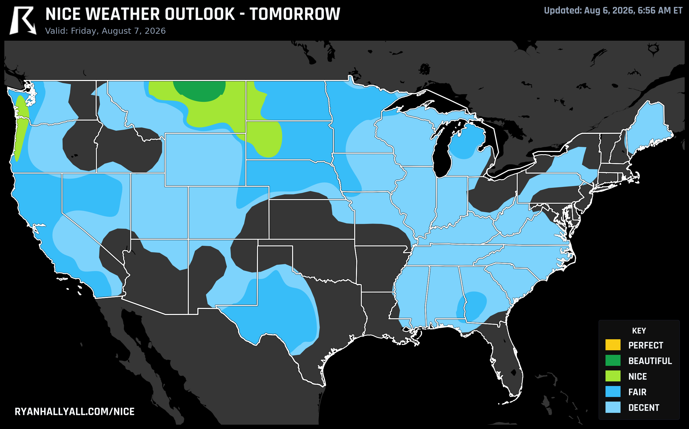
A little further south and west, Rapid City posts a score of 74.8 and lands in Nice, part of a broader Northern Rockies/Intermountain West zone that's carried by near-maxed dewpoint and heat stress scores. Rapid City sits close enough to Sturgis that a lot of riders rolling into the rally Friday will be doing it under genuinely pleasant skies. Just don't skip the sunscreen or the smoke check. UV is high and there's enough haze in the air that a clear-looking sky can still carry some particulate load.
Meanwhile, back in the Bay Area, Friday cools off just a touch in the rankings. San Francisco and San Jose both slide from Nice down to Fair as onshore cloud cover picks up, still a perfectly pleasant Outside Lands day, just not the state's top spot anymore.
The longer view: the Pacific Northwest is the week's safest bet
Zoom out past tomorrow and a clear pattern emerges. Saturday through the middle of next week, the country's most dependable Nice-tier air sits in the inland Pacific Northwest and northern High Plains, a dry slot that holds up day after day while the central Plains and Midwest wrestle with a slow-moving frontal complex and rising thunderstorm coverage. Portland, Salem, Eugene, and Seattle all cycle through scores in the high 70s to low 80s through Wednesday. Coastal Oregon and Washington towns like Tillamook, Garibaldi, and Montesano show up across the entire seven-day window in our weekly rankings, a sign of just how steady that corridor is right now.
Santa Barbara's stretch of the California coast, including Carpinteria, Montecito, and Goleta, is the other name that keeps popping up on the week's best-city list, benefiting from the same dry, clean airmass that's carrying today's Wine Country comfort.
If you want to track where the country's best air moves next, the Nice Weather outlook page updates daily with the zones, scores, and the specific gates keeping any given spot from climbing another tier. For now, enjoy the coast today, and if you're headed toward the Hi-Line or Sturgis tomorrow, you picked a good week for it.