Blog Article
Monday Peaks at Beautiful for Oregon and Washington's Valleys
Willamette Valley and lower Columbia towns hit Beautiful on Monday, the week's high point, while heat, smoke, and storms squeeze the rest of the country.
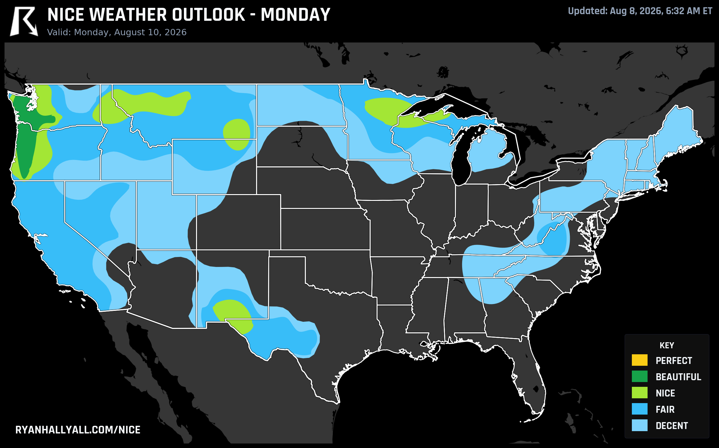
Monday Is This Week's Ceiling: Oregon and Washington's Interior Valleys Peak at Beautiful
There's a lot of uncomfortable weather in the forecast this week. Triple-digit heat is baking the San Joaquin Valley and the Rio Grande Valley, dewpoints are sitting in the sticky 70s from the Plains into the Mid-Atlantic, and wildfire smoke keeps nudging air quality readings higher across the northern Intermountain West. Against all of that, one corner of the country keeps quietly winning, and one specific day this week is the best it gets.
Today and Sunday: a familiar, dependable stretch
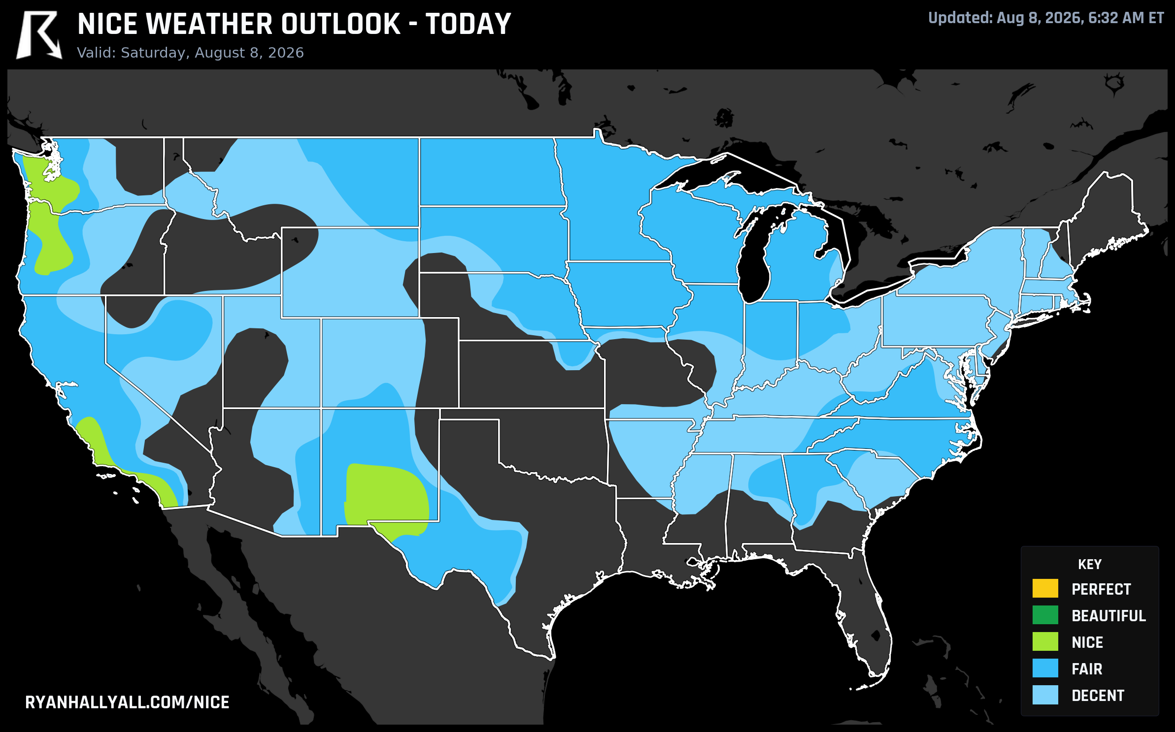
Saturday's best real estate runs from coastal Southern California up through the Cascades and Great Basin. San Diego (81.0), Eugene (80.7), Santa Maria (81.2), Portland (79.6), and Long Beach (78.3) all land in Nice territory today, riding dry air and mostly clear skies. The catch is air quality. The broader Intermountain West zone is capped below Beautiful not because of temperature or sky, but because a max regional AQI reading of 91 and lingering wildfire smoke trip the tighter gate the next tier up requires. It's a good reminder that a nice-looking forecast can still carry a haze asterisk, especially if you have asthma or are planning a long outdoor day.
Sunday brings a similar map, with El Paso (81.5), Portland (81.6), Salem (82.0), and Eugene (92.0) leading the country, plus a genuinely nice bonus for the East Coast: a cold front clears out the muggy air behind it, dropping Northeast dewpoints into the 50s and 60s for a few hours of relief. If you're headed out for any of Sunday's ballgames or catching the Grand Prix of Portland that afternoon, both areas are working with comfortable, low-humidity air, though Portland's race fans should still expect a stiff dose of afternoon sun (UV running 6.7 to 8.8 across the zone).
Monday is the outlier, and it's a good one
Here's the actual headline. On Monday, August 10, the interior valleys of western Oregon and western Washington post the kind of numbers this outlook rarely sees: 100 out of 100 on precipitation, upper-90s on temperature and dewpoint sub-scores, just 7 percent cloud cover, and an AQI of 39. Portland, Tacoma, Salem, Eugene, Grants Pass, and Longview all land at Beautiful, the highest category touched by any city, on any day, this entire week.
What makes this genuinely interesting is how close it comes to going even higher. The underlying zone score sits at 90.9, only about a point off the next threshold up, and every single sub-score already clears the bar required for that top tier. The only thing standing in the way is a forecast-day rule: the outlook only allows its highest rating on Days 1 and 2 of the cycle, so Monday's air mass, which is arguably good enough to earn it, gets held at Beautiful on a technicality rather than a weather one. Highs run 79 to 91 degrees depending on elevation and distance from the coast, dewpoints hover around 49, and winds stay light, 7 to 13 mph. Grants Pass runs the warmest of the group at 91 degrees and still scores a 92.0, while breeze-cooled Lincoln City, sitting in the low 70s, matches that same score. UV still reads High (around 7 to 7.6), so sunscreen stays on the list even on the best day of the week.
The rest of the week doesn't fall apart, it just gets capped
Days 4 through 7 keep the same basic shape: a stubborn ridge over the interior West and Southeast, troughing near the coasts, and the Pacific Northwest corridor holding its Nice rating day after day, just under a forecast-day ceiling that keeps it from climbing back to Beautiful this cycle. Portland, Seattle, Salem, Eugene, and Bend all stay in the high 70s to low 80s on the nice weather score straight through Friday, August 14. Zoom out to the full seven-day picture and Eugene tops the entire country's weekly leaderboard with a 84.7 average and seven out of seven Nice-or-better days, with the small Willamette Valley wine towns of McMinnville, Dundee, Lafayette, and Carlton right behind it. If you've got a wine country weekend on the calendar, this is the week to take it.
Worth a mention while we're on longevity: Sacramento, Oakland, Stockton, and a long list of Central Valley and Bay Area cities are currently riding a 61-day live streak of Nice-or-better weather, dating back to early June. That's an unusually durable run for inland Northern California in the middle of summer, and it's still going as of today.
The other side of the map
None of this is happening in a vacuum. WPC has a Slight Risk of excessive rainfall up today for the Low Country of South Carolina and Georgia, tropical moisture is pushing heavy rain into Charleston and Savannah, and a more organized severe weather setup builds across the Midwest and Great Lakes Sunday into Monday, with damaging wind gusts the main concern from Chicago into western Pennsylvania. Meanwhile, hot, dry conditions across the northern Intermountain West are keeping fire weather elevated, with relative humidity dropping into the teens and gusty winds mixing down each afternoon. If your travel plans run through any of those zones this week, it's worth checking the Nice Weather outlook page before you lock in outdoor plans, since the gap between the best and worst weather in the country right now is about as wide as it gets.
Bottom line: if you can be in the Willamette Valley or the lower Columbia corridor on Monday, you're getting the best air the whole country produces this week. Everyone else gets a solid, familiar version of Pacific Northwest comfort through the weekend and into next week, with the usual smoke and heat caveats attached everywhere else.