Blog Article
Nice Weather Outlook: New England's Near-Perfect Saturday
Manchester, Portland, and Bangor hit a Beautiful-tier Saturday, just shy of Perfect. See where the best air goes next, from the Dakotas to a 67-day SoCal streak.
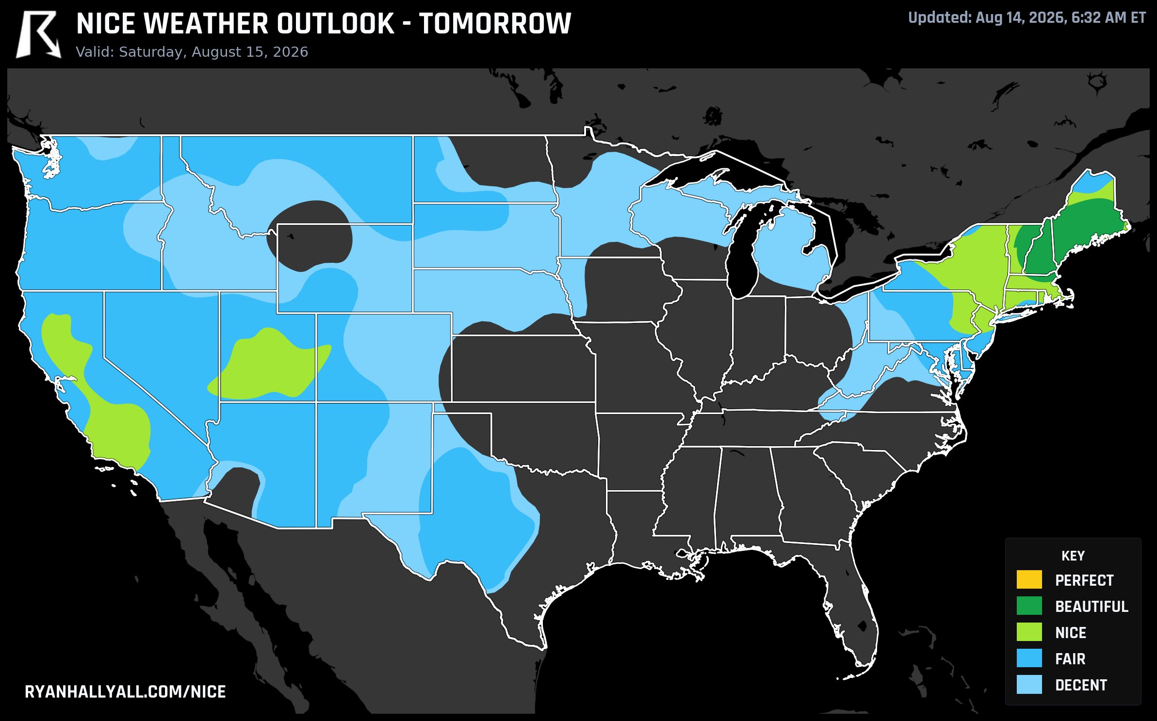
Northern New England Gets the Closest Thing to Perfect This Week, and the Dakotas Are Next
Most weeks, the best air in the country parks itself in one spot and doesn't move much. This week it's doing something more interesting: it's building toward an actual peak, hitting it Saturday in northern New England, then handing the baton to the northern Plains on Sunday before the whole pattern settles back down. If you like tracking the map, this is the week to do it. Check the Nice Weather outlook page day by day and you can watch it happen in real time.
Today: a scattered start
Today's best conditions are patchy rather than one clean blob. A building ridge has scoured out humidity over eastern Washington, northern New England, and pockets of the interior desert Southwest. Tucson tops the list at a score of 82 with clean air (AQI just 37), while Sacramento, Stockton, and Oxnard are all riding the same dry, high-pressure air mass out west. Spokane makes the list too, though it's carrying some drifting smoke that keeps its score in check. The nationwide ceiling today is Nice, not because anything is wrong, but because wind and temperature are running just a touch outside the sweet spot even in the best zones. UV is sitting at 7.4 in that top tier, so sunscreen still matters even on a good-air day.
Saturday: New England's near-perfect day
Here's the day worth circling. High pressure and dry Canadian air settle over the central Northeast and northern New England Saturday, and Manchester, Portland, Bangor, Berlin, and Barre all climb to Beautiful, the second-highest tier on our scale. The numbers back it up: highs near 71°F, lows near 53°F, dewpoints around 52°F, rain chances at just 1%, and winds light enough that a picnic blanket stays put.
What's genuinely fun about Saturday is how close it comes to the top tier, Perfect, without quite getting there. Every comfort factor except two is basically maxed out. Cloud cover sits at 30%, just shy of the threshold that tier requires, and air quality averages an AQI of 39, four points over the cutoff. Trim a little haze and clear a bit more sky, and this would be the rare Perfect day. As is, Beautiful is still the best score of the week so far, and it's a genuinely lovely one for a patio breakfast in Portland or a walk around Manchester before the Bills host the Panthers up in Orchard Park, which sits well inside the broader Nice-to-Beautiful footprint stretching across upstate New York that same afternoon.
A broader Nice zone spreads from the Northeast through the Great Lakes fringe and into the interior West on Saturday too, covering Buffalo, Albany, Boston, and Burlington. If you're at the Chicago Air and Water Show that day, know that Chicago sits closer to the Fair zone, with more cloud cover and a slight severe thunderstorm risk from SPC hanging over the Ohio Valley and central High Plains. Worth a radar check before you head to the lakefront.
Sunday: the baton passes to the Dakotas
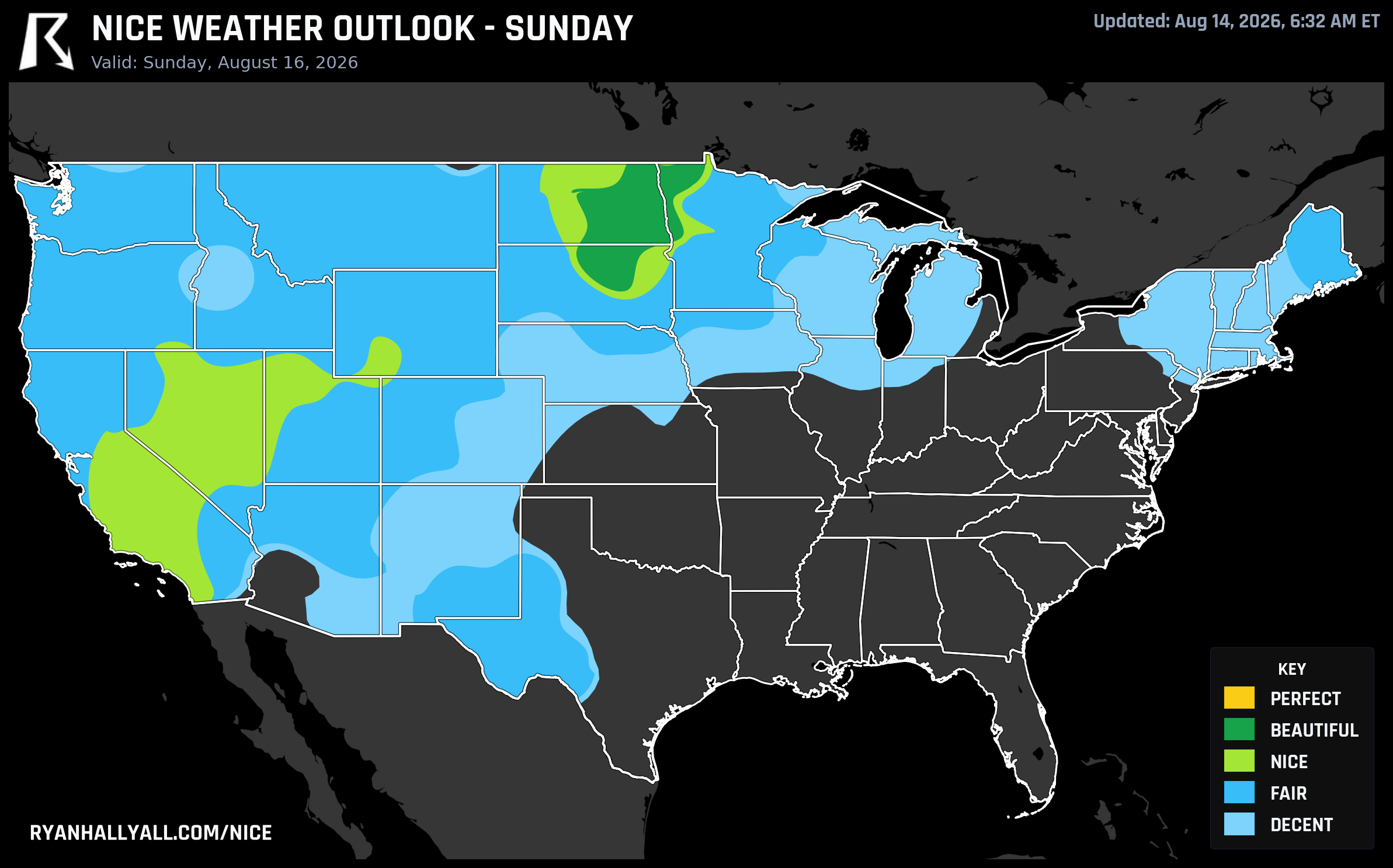
By Sunday, the same near-miss pattern shows up a thousand miles west. Fargo, Grand Forks, Aberdeen, Jamestown, and Devils Lake climb to Beautiful, with Fargo posting the day's top city score at 92. Highs run near 85°F with dewpoints near 54°F and only a 4% chance of rain, dry Canadian-influenced air doing the heavy lifting again. A broader Nice zone spans the central High Plains and interior West that day too, though it's held back specifically by air quality rather than temperature or moisture, with some CAMS readings spiking well above the clean-air threshold in isolated spots.
Days 4 through 7: back to a Nice ceiling
After the weekend's brief run at the top tier, the pattern eases. A broad ridge holds hot weather over the south-central and southeastern U.S. through the extended period, while a lingering boundary over the Midwest and Great Lakes keeps cloud cover and shower chances high enough that most of the country tops out at Fair or Decent. The best available air drifts from the Upper Midwest and interior West on Monday, to a genuinely clean Ohio Valley/Mid-Atlantic corridor Tuesday (Philadelphia, Columbus, Cincinnati all scoring 82), and back to the Southern California coast and interior West by Wednesday and Thursday. Every one of those days is capped at Nice by the forecast-day math itself, so don't expect a repeat of the weekend's near-Perfect showing until the ridge relaxes.
The quiet streak nobody's talking about
While the headline tier is bouncing around the map, one region just keeps doing the same reliable thing: the Southern California coast and Central Valley. Shasta, Sacramento, Stockton, Oakland, and a long list of Bay Area and Central Valley cities are sitting on 67-day streaks of Nice-or-better weather, dating back to mid-June. Meanwhile, our weekly rankings have Camp Pendleton North, Mission Viejo, Laguna Hills, and a run of Orange County and Ventura County communities logging Nice-or-better conditions on all seven days of this outlook, with Oxnard, Ventura, and Santa Barbara all touching a score of 92 on Friday alone. It's not flashy, but it's the most dependable nice-weather machine in the country right now.
The caveats worth knowing
None of this is happening in a vacuum. WPC still has dangerous, long-duration heat locked in across the Southern Plains and Southeast, with heat indices running 105 to 115 degrees and little overnight relief, and a Moderate risk of excessive rainfall continues today from Iowa toward the Appalachians on ground that's already soaked from this week's flooding. The nice pockets above are real, but they're pockets, not the national story. If you're traveling into any of the zones we've flagged, keep an eye on UV (routinely in the 6.5 to 8 range even on the best days) and on localized haze, since a few interior West spots are carrying enough smoke to notice even when the official score stays comfortable.