Blog Article
Nice Weather Outlook: Dakotas Near-Perfect Sunday, Map Shifts All Week
Sioux Falls and Fargo flirt with Perfect today while the nation's best weather corridor moves through the Upper Midwest, West Texas, and the Rio Grande valley this week.
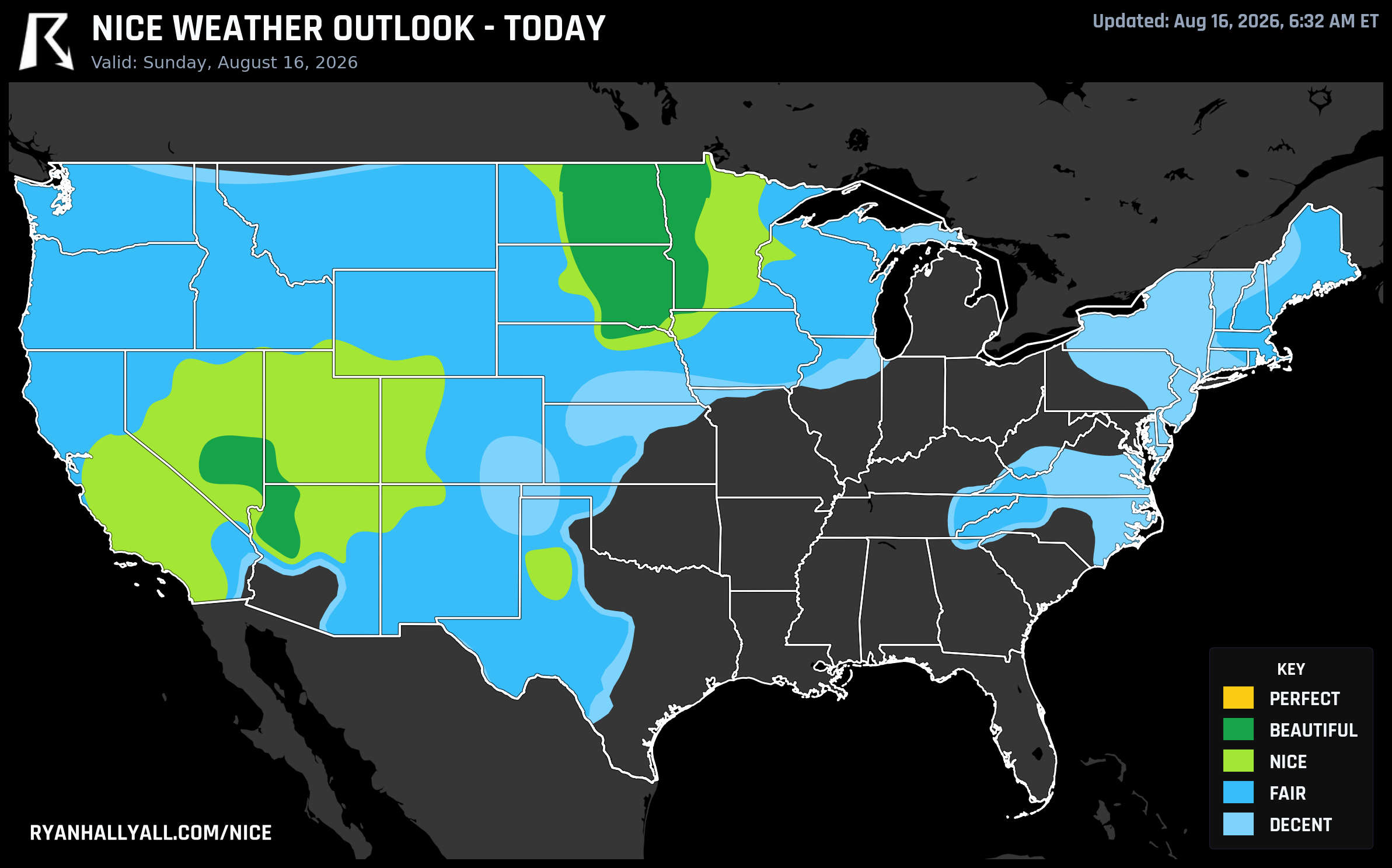
The Dakotas Come Within a Few Gates of Perfect Today, Then the Nice-Weather Map Splits Into Two Camps
Someone in Sioux Falls is having a really good Sunday. Highs near 80, a dewpoint sitting comfortably at 55, barely any wind you'd call bothersome, and a sky scrubbed down to about 15 percent cloud cover. It's the kind of day that makes you cancel indoor plans without a second thought.
Across the Dakotas and into Minnesota, today's outlook tops out at Beautiful, and it's close to something even better. Sioux Falls, Fargo, Grand Forks, and Minot are all posting scores around 92, and the zone-wide composite comes in at 89.1 out of 100. Precipitation, dewpoint, sky, and temperature sub-scores are all in the mid-to-high 90s. What keeps this stretch out of Perfect is a trio of hard limits: wind sub-score at 88.5 against a 92 floor, UV running 7.1 against a cap of 7, and AQI at 42 against a 35 ceiling. None of those is a real problem on the ground, they just happen to trip the fine-print gates our top tier requires. St. George, Utah rides in the same Beautiful tier but with a rougher edge, gustier terrain wind and a UV of 8.1 pulling its individual score down to 72.
One tier down, Minneapolis is having its own quietly great day, drier post-frontal air pushing dewpoints into the upper 50s ahead of this afternoon's Phillies-Twins game at Target Field. Lubbock and Salt Lake City are in the same Nice bracket, both comfortable but both nudged out of Beautiful by air quality just north of the safety cap rather than anything to do with temperature.
Here's the honest caveat for today: this good air is an island. A moderate risk of excessive rainfall is centered on West Virginia, with slight risk stretching into Pennsylvania, Maryland, and Virginia and marginal risk reaching the Ohio Valley, the same corridor that's already absorbed repeated flash flooding this month. A slight severe risk covers the central High Plains too, with hail and damaging gusts possible into this evening. The heat problem is separate but just as real, a long-duration warm ridge is keeping the South and Southeast in dangerous heat, which is why places like El Paso and Denver land in the Fair or lower tiers today despite dry air, gusty wind and rain chances doing the damage instead.
Monday: The Baton Moves to the Upper Midwest and West Texas
Tomorrow the Beautiful tier drifts into a corridor running from Lubbock northeast through Green Bay, Appleton, Waterloo, Oshkosh, Dubuque, and La Crosse, with St. George and Prescott holding on out west. The zone score is 87.3, again just short of Perfect, this time because wind and sky cover are a touch too generous rather than truly bad. Waterloo, Oshkosh, Dubuque, and La Crosse are all posting 92s. If you're planning a Monday outdoors in Wisconsin or eastern Iowa, this is close to as good as August gets: dewpoints near 53, rain chances around 3 percent, and AQI a clean 42.
The catch elsewhere on Monday is cloud cover, not heat. Sky sub-scores fall from the low 90s in that Beautiful corridor down into the 50s across the broader Plains and Midwest, which is why Chicago and Denver stay stuck in lower tiers even with reasonable temperatures.
Tuesday: Mid-Atlantic Highlands and the Rio Grande Valley Take Over
By Tuesday the map reshuffles again. The best air settles over higher-elevation Pennsylvania, Altoona and State College, alongside the dry Rio Grande valley around Las Cruces and El Paso. That's an odd pairing on paper, mountain towns and desert valley, but both share the same recipe: light wind around 9 mph, near-zero rain chances, and cloud cover under 25 percent. Altoona and Las Cruces both score 92. El Paso and Socorro run a touch warmer with UV near 8.7, still under the safety threshold but worth a hat and sunscreen if you're outside midday.
Meanwhile Seattle, Portland, and Cleveland slide into the Nice tier the same day, held back from Beautiful by cloud cover rather than temperature, a theme that keeps repeating through this stretch: the sky, not the thermometer, decides who makes the top tier.
The Quiet Consistency Play: Southern California
If you want fewer surprises rather than a single peak day, look at San Diego County. Places like Goleta, Escondido, El Cajon, and a dozen other communities around San Diego are running live streaks of Nice-or-better weather stretching back 69 days, one of the longest active runs anywhere in the country. None of these towns are chasing Perfect this week, but they don't need to. That kind of marine-layer-tempered consistency is its own reward if you're planning a trip around guaranteed comfort rather than a specific ceiling day.
For the full seven-day picture and the city-by-city breakdown, the Nice Weather outlook page has the daily maps and rankings as they update.
Bottom line for the week: chase the Dakotas and Upper Midwest through Monday, then look toward the Pennsylvania highlands or the Rio Grande valley Tuesday. Just keep an eye on the Ohio Valley flood corridor and the Southern heat dome, because they're not going anywhere while the nice-weather baton keeps moving.